Good Sunday, everyone. Our ugly weekend is wrapping up with more cold air pushing into the region from the northwest. This is a continuation of our MUCH colder than normal February and we have more shots of bitterly cold temps in the week ahead.
Let’s start with today and roll forward.
Watch for slick roads out there today as things begin to freeze up. That will especially be true for the first part of the day and again later tonight as temps crash. A few snow showers or flurries may be sandwiched in between with low clouds and fog around.
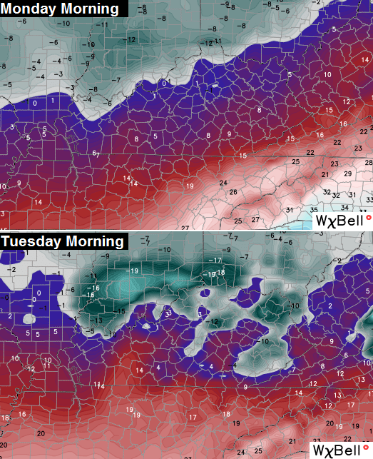
Overnight lows over the next couple of mornings will drop into the single digits, at least. The models are suggesting those areas that still have a lot of snow on the ground may drop below zero…
Another arctic front dives in late Wednesday and may bring a period of light snow our way. The Canadian Model is trying to develop a wave of low pressure along this boundary as it swings through here…
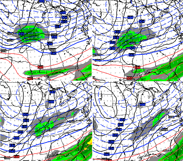
Let’s keep an eye on that to see if it can blow up into something a little more robust in the coming days.
The air behind this looks even colder than the one we have over the next few days…

At this point… why not? If it’s going to be this frigid, we might as well go all out with it!
Think of this… the week ahead of us will likely bring, at least, 3 or 4 more days of single digits or lower temperatures. Amazing doesn’t begin to describe the pattern we are in at the moment.
It doesn’t end there… keep watch on the southern branch of the jet stream next weekend. It may try to spit out another storm system.
I will have updates later today. Take care.

It seems that once winter got our attention, it wanted to keep our attention. Thanks for all that you do!
I just don’t understand mother nature sometimes. No meteorologist, computer model, blogger, person, dog, cat, sofa, snowfake, or goat got this forecast right with this extremely complex system. Record low temps in the negative teens and 20’s followed by powerful warm air advection has never happened before. There is literally nothing to compare this to. Richmond went from -32°F to +39°F in a matter of 36 hours!!! Folks, that’s a 71 degree temperature rise. That is nearly unheard of in any place, and extremely rare. Let alone heavy rain which amounted to an inch and a quarter. That is what caught us off guard, we underestimated the warm air advection that nearly always kills totals in Kentucky. But who knew? No comparisons to a previous event can be drawn? NEVER underestimate the southerly flow! (AKA, WAA)
To make matters more complicated, this event was a hella of an overachiever to the east of us. Parts of borderline Eastern KY to the north and south overachieved in snow amounts. In Washington D.C., They had an overachiever as the models didn’t pick up the arctic air in place over there, as it was too strong.
So nobody can be blamed here except mother nature, she does as she pleases. We at least escaped what could’ve been a ten times worse storm if temps actually stayed below freezing as they were forecast to go. In fact, it seems like the models nailed this one past 3 days or so, when they were bringing in rain and 40’s. They trended colder and became less accurate as we got closer to the event, which is very odd. this has been a historic week for sure, and is one that we will be talking about for years to come. So just be happy and put a smile on! 🙂 “Enjoy the weather, because it’s the only weather you got!” ― Joe Bastardi
―Israel
Did not even think of that situation. 71 degree temp jump. I thought it was crazy for Louisville to go from -6 to 38. Very true on your post.
The all powerful southwest wind, nothing can stop it not even negative 20 degree temps.
Great post — thanks for putting things in perspective!
Richmond was not -32. The mesonet site in Waco was.
It was -18 when I left for work. That is cold enough!
And -18 in Danville, which helped kickistart a nasty chest cold. Bad enough is right! 🙂
Thanks so much, Chris. You gotta be one worn out weather dude!
This has been a truly remarkable and historic week of winter. One we’ll remember for years to come.
Looks like it might have a little left in the tank too.
Take care everyone.
Thanks CB for the update. Looking forward to a quiet couple of days. Hope the Wed system blows up into something bigger, but I hope the weekend system does not. Heading to Wisconsin Thursday night and don’t want to have to cancel the trip.
It’s a beautiful morning in Kentucky
Think spring!
Looks like a decent amount of snow with that system in the Plains. Where is it going? To the southeast of us? I guess if it heads our way, more rain.
the Cumberland is already full and there are still plenty of snow on the ground. The last thing we NEED is rain or any precip for that matter but do I want snow yeah I could go with more
Thanks Chris. This has been one wowza of a weather week for sure! Yesterday was just unbelievable, with the way the storm went. I think you did an excellent job with it. You have to be dragging. Even after all the rain we still have about 6-7 inches of snow on the ground at our house. From the sound of the temps it’s not going to go away in the next two says either. Was glad to finally get a big snow. If we get more that’s ok but if not that’s ok too. I’ve had the big one I wanted. Have a great Subday everyone and please stay safe and warm. Thanks again Chris for all you do.
Just looking at the storm in the plains also …..I’m also wondering if it might head this way? Whatever. We will deal with it. Chris will let us know, I’m certain of that. Chris you do a great job of keeping us informed. Thanks!
Thank you, Chris, and thank you fellow bloggers for all the great information during yesterday’s storm. Enjoy the sunshine this morning!
Posted earlier about a “post audit” of this epic system but my post is not showing then when I try posting I’m told its a duplicate post. What gives?
That happens to me from time to time. Maybe the blog software automatically filters if it sees some combination of words?
The blog blocks words that contain inappropriate words within. Words like “Bluegra-ss” “Uncert-aint” or “a-ssume” are blocked by the autobot. You should always add a – in the middle of the word. Get in the habit of copying your comment before posting just in case it disappears and if it does, double check.
Never doubt Mother Nature’s power and/or unpredictability. One more decent snow this week would make Rodger ready for spring.
I’ve been watching the extended forecasts for a while now and the warmer (average) temps are always getting pushed back a week. I don’t know when we ever go back to average. Three years running now that the cold just doesn’t want to leave.
We have so far dodged heavy ice, so that is at least good. Getting missed by the heavy snow this time is a win for a lot of folks too, since would have kicked a lot while down. That would have been bad for another week at least.
I am getting more concerned though for the potential of a rough start to spring due to potential cold and warm air battles.
I like snow in the winter. Never ready for winter to end until spring and I am usually not one who calls for early season starts. But I am glad we did not get a huge wet snow. I do wish the rain would have melted more of the snow. Still just about as thick but real heavy. Road is a solid sheet of thick ice. 4 wheel drive will not go on this so we are stuck. Cold temps mean we might be stuck for a few days.
With wkyt showing below freezing highs and snow chances I wonder about this week. Not sure if the kids get any school in.
As for the spring I was thinking the same thing. Could be very active if the cold continues to try and push in with the warm making its play.
Just watch the national radar there’s a band of snow just to our west and looks like its headed right at us in western, ky
Thankfully the temps here didn’t go below 34 and there was no freezing.
Last night?
Yes
Hearing talk about the midweek system trending northwest. Hmm.
Very minor
Could be more than minor for SE KY if it continues to come north and strengthen. It has exploded on the 12z NAM run.
Exploded as in it looks like it will hit KY?
No, but showing 8+ inches for a large part of Alabama and Georgia and 4+ inches between Chattanooga and Knoxville. Wouldn’t take much more northern shift for that to cause problems for SE KY. Of course that is only one model that is also notorious for overdoing accumulations. Still bears watching over the next day or two though.
The storm system out west of us looks as though it’s going to go south of KY. Looks like it has lots of nasty to go around for everyone from Texas on south and east of us. Dodging that one. Whew!
The storm system west of us looks like it is aiming for Southern Kentucky to my very untrained eye ! What’s going to happen with that Chris Bailey or anyone ???
I noticed that also. My guess is it will go south or if it heads toward us, it will turn on the southwest wind again…..rain anyone?
No thanks the 3 inches of rain we had yesterday was plenty for a while.
I’m going to keep an eye on it . Don’t need any surprises !lol
Looks like the GFS is trending warmer than it was in the long range. Wouldn’t hurt my feelings.
yeah some real signs of spring showing up in about two weeks. There is some serious warm building in Central America. That will break north fairly soon.