Good Saturday afternoon, everyone. The past 7 days in the bluegrass state have been nothing short of amazing and historic. Let’s review:
– We started the week with the biggest snowstorm in nearly 2 decades.
– That was followed up by a 2″-5″ snowstorm that helped give us one of the deepest snow packs on record.
– Every single day featured single digit temps or colder.
– History making cold moved in for Thursday and Friday with records absolutely smashed.
– Friday morning gave us some of the coldest temperatures ever recorded in the state of Kentucky.
– Last night and today… another winter storm slammed the region with sleet, freezing rain and snow.
This is a week that is now legendary and one that will be the standard bearer for years to come.
Yet, some people are complaining it hasn’t been bad enough. If that’s you… you should probably take a step back and reexamine your life. 🙂
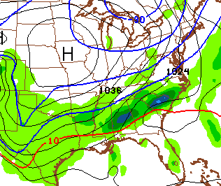
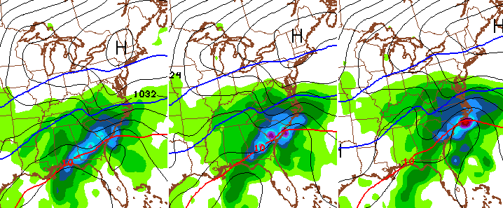
Let’s see where we go from here and start with what’s left from our current winter storm. This thing is an absolute beast with the amount of precipitation it’s producing and the temperature profiles. Not a whole lot of consistency with the profiles and that’s why you are seeing random places in different corners of the state getting heavy snow.
Heavy rain, snow melt and ice clogged waterways will lead to high water issues for some in western and southern Kentucky.
Temps will drop below freezing tonight and that will make everything ice up… use caution if you’re out driving.
From there… it’s more harsh winter weather. Another shot of arctic air moves in late Sunday into Sunday night and could produce some light snowflakes…
That brings in another round of single digits and possible below zero numbers…

Another arctic front sweeps in on Wednesday with some snow showers. Guess what follows that up?
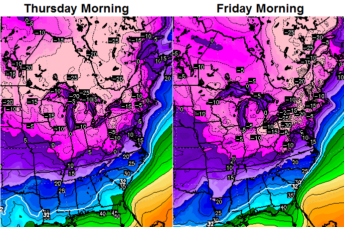
We’re already on pace for one of the coldest Februarys on record… the week ahead of us will only push us closer to the top.
A few days ago, I started talking about another signal for a winter weather even showing up for the end of next week into the weekend. That signal is still there and is a littler stronger. A storm system shows up on all the models…
If you are tired of the harsh winter weather… I wish I had some better news. This looks to continue deep into March!
At this rate, many schools will be in session through June, again. That leads me into this song that teachers should love. It even gives your friendly weatherdude a shout out…
I leave you with your tracking tools for the rest of the afternoon…


Take care.

Thanks Chris for keeping us informed!
The guy in the video should try out on “The Voice!” As a teacher, he is sooooo right! Jefferson Co. is already going into June. How many more days remains to be seen.
Spring please
thx for the update ….this storm last night/today will be the standard bearer for a nowcast storm…amazing storm
I heard a lot of roofs are collapsing in Harlan County.
Yes, businesses and homes are having roof collapse. Many of the metal car ports too.
my daughter’s porch roof collapsed in Madison county.
Thanks Chris. We’ve run the gamut here but have had rain with a little sleet for the past several hours. Out streets are a mess! Lots of pending and slush will make it fun after while. Thank you for everything you do to keep us informed and safe. Appreciate all your hard work to keep everyone updated. Have a safe evening everyone. Stay warm and GO CATS!!
Chris thanks for keeping everyone updated!!
Enjoyed the song! Awesome! Everyone stay warm!!❄️❄️⛄️⛄️
Very little ice before dawn been all rain since day break in Carrie of knott co. Ditches are flowing over and creeks getting high should have some sort of flood alert instead of continuing a wsw for rain
This. I have no idea what the NWS is thinking. We have had over 2 inches of rain and no flood warning but a WSW.
Finally got one in knott co. Can’t believe how slow it was getting it
3+ inches of rain/precip in Murray since midnight? Man that’s a lot of water.
We are sure making up for the lack of storminess in Dec and Jan……That’s for sure! I think it’s so cool to have lived through this record week……This entire week has felt like it’s lasted a month. There’s still a LOT of snow on the ground.
OK, it’s time to warm up…
I love snow. However, this is now delaying my new home being finished.
Need the snow gone and above freezing temps to pour the concrete and set the stone.
Otherwise, the March 10th closing won’t be happening.
We can have snow AFTER that date, lol
What could have been. Nam had the precip correct not the temps. Oh well I guess a cold rain is better than shoveling 10 inches of wet snow. Still find myself looking outside for a change over to snow here in the Ville. Not today! Ha ha
100% this! And losing power, removing snow from roofs, getting stuck at home, kids out another week from school and losing power. Yes I put that twice 🙂
The Torch has helped keep this from dragging on another week with the problems noted above. It helped provide a little relief for a lot of people as far as not piling on on top of the big stuff.
keeps on going back and forth (snow, sleet, rain) on the NE side of Lousville.
All day long…a slushy mess.
I am guessing the kids might just miss another week at least. From asking around the 35 degrees i have is what some others are seeing. Weather.com is in agreement. The mesonet does say 38 so some places in the country may be warmer. But the snow is holding on. Still deep here. Slush in the road is deep. Is supposed to freeze tonight and then only slightly warm tomorrow before dropping off. Chance of snow for tomorrow night if weather.com is right
Look at the positive side of thing, at least nearly the whole state is above freezing with rain to wash away most of the ice and snow from roads. Also a widespread 2-3″ of rain has almost, or has wiped out the drought we were getting into. And all this water will help moisten your yard so your spring plants will have plenty of water and nutrients to thrive in the precious KY soil.
Also, as CB said, we have SURVIVED one of the most snowy and cold snaps to ever hit the state of Kentucky! We will now enjoy our spring even MORE than ever before since the 90s!
If we all got slammed with this one, a lot of us would have been in, “Help I have fallen and can not get up!” mode.
I am 100% fine with not having to remove double digit heavy snow from my driveway 🙂
And not having to “imagine” the Cats game in my mind tonight, since about 100% we would have lost power and been stuck at the house tonight.
Wow! What an exciting week of winter weather we have had! Memorable for sure. I have a feeling we will be referencing this week for many years to come. Thank you for the dedication to this site and keeping us informed Chris. I hope there is a break in the action so you can catch up on some much needed sleep!
We had an awesome afternoon in the snow here in Lexington! Finally got the chance to get out and enjoy it! Thanks for your dedication CB!
Harlan county has been absolutely pounded. Several business roofs have collapsed, and countless car ports. Many without water and/or electricity. Just heard a man was trapped under his carport, and the ambulance was stuck trying to get to him. (The last one is from FB, so take that as you will.)
Please tell me your prediction is that FAYETTE COUNY schools will be back in session all week next week. 🙂
Got up around 3:30 AM here in Letcher County to see a thin layer of ice/freezing rain on the vehicles outside. Started raining here this morning around 9:00 and that is all that’s happened since outside. Pouring the rain here now. Between London and Harlan who apparently got a bunch of snow throughout the morning. Only thing we have to worry about here is flooding. Weather Channel/ NWS in Jackson is giving us 34 degrees last night so I doubt this will freeze back. Chris Bailey is giving below freezing but that’s for central KY.
Chris we are so lucky to have this blog it is so needed you never rest you are always giving us updates I love the winter and cold but its ok I think I have had enough I don’t know Chris i think I could handle another big snow
Sure you could don’t sell yourself short.
Rain Rain go Away 😉
Come back on a warm spring day!
yeah when there isn’t 6 inches of snow to melt LoL. I’m ok with one or the other but not both at the same time.
Drizzling rain and 37 degrees in the Millville area. We’ve had either all rain or nothing for the last couple of hours. Fog is beginning to rise up from ground in the holler. Thanks, Chris, for helping us get through this historic week of weather. You the man!! 🙂
Good song!!! I know that dude! Good man, good singer.
Think spring
Think spring
Think spring
Think spring
Think spring
Think spring….
Mr. Mc Broing-broing!
Think snow
Think snow
Think snow
Think snow
Think snow
Think snow
Ha ha
Think ice
Think ice
Think ice
Think ice
Think ice
Think ice
Die Winter, Die.
Ok, I am loving the snow days (not so much the extreme cold) but I completely agree that the pressure put on us for rest scores is crazy. And yes, the kids will check out about mid to late May. Teachers will give it a really good try, and eventually lose the battle and be too tired to fight it. So, why is there some politicians who can not see this? Must not have kids.
Flood warnings just announced for counties in the Floyd, Martin & Pike area until 9:30 this p.m. issued from Charleston, WV.
Jackson NWS has finally jumped aboard ship as well, all of SE KY under flood warning until 9:30 PM.
Lot water under the snow and on roadways, lot snow left from monday storm northern clay co
when this refreezes it’s gonna be a mess
That’s my issue. Road was cleared fairly well when they came out couple days ago but left a little bit since they cannot get it all. Sides of the road had a lot of snow, well over 2 feet since we had over 15 inches. With the rain last night and cold the road was solid ice. Then we has snow and sleet on top of that. Has been pouring a mix that is mostly rain for a while and the water is standing on this. As this freezes up we could be looking at a few inches of ice on most of the road.
And the yard is a mostly snow slushy mess. Walking in it just packs it down and leaves a packed layer of 4 or so inches. When this freezes tonight/tomorrow it is going to make for a long stay in here.
The big plow just went down or street in Lexington and it’s now a bigger disaster than it was this morning… oy. Standing water on the roadway and 3 ft snow drifts in front of everyone’s driveways that you have to plow standing in 5 inches of water. Not that I’m not grateful… but eesh.
Shorty shorts weather on the horizon.
Now think about this – there will be no more references to 1998. Now it will be 2015……Not to minimize what happened in 1998, but still.
I would like one more but mainly because it’s fun coming on here & tracking it all. 🙂 That & I’m not ready to get on that dreaded treadmill. UK hoodies cover up more. 😉
Well that just might happen next weekend with a southern system.
Thanks for all your hard work, Chris. I am grateful for you keeping us informed. I truly enjoy your blog, too. (I am kind of wanting just one more snow event…ok, I’m ducking and running.). 🙂
An addendum to the WSW til 7pm from the Jackson NWS…..
“UP TO A HALF INCH OF TOTAL ICE ACCUMULATION IS EXPECTED…WITH
AN INCH OR LESS OF SNOW AND SLEET ACCUMULATION. THE EXCEPTION
WILL BE PORTIONS OF BELL COUNTY…WHERE TOTAL SNOW
ACCUMULATION WILL EXCEED 6 INCHES IN PLACES.”
Will someone please tell these idiots that many locations in Bell have already exceeded 12 inches from this storm. NWS comedy at its best! lol
This
CB I just don’t think it can be said too many times, thank you so much for all you do! My dad is a retired Air Force Met (30 years). I always share updates with him whether it’s winter, or severe weather. Col. Hood RET thinks you are one of the greatest a Mets out there! I remember the weathers days with weather charts and the grease pencils lying around out in his weather center. Good times! You are appreciated and well thought of, now get some rest! :o)
We are under a flood warning here in Pike and surrounding. Neighbors carport roof collapsed on car. They are reporting flash flooding.Rain continues.
i dont wanna disagree with you chris, but i dont think this is biggest snowpack ever at my place in 1993, 1994, and 1996 there was 2 feet of snowfall in clay county. this snowstorm this week was 10 half inches at my place, then a 2 inch on top of that. you are correct tho on it being a historic week of winter weather.
im ready for spring mode but dont think spring will be here any time soon.
thank you chris for all that you do for us weather weenies
I just want to thank you Chris Bailey for awesome job you do. You go way beyond. One thing for sure that I have promise myself is no matter how hot this summer gets I will never complain. I pray how soon Spring weather comes. Thank you once again for all the hard work you do for the people of Kentucky.
needs a like button for this comment.
Loved the song, most of us don’t show movies after testing. Thanks, Chris, for your forecasts and knowledge. It helps us to plan and not get caught off guard. You are the only one I go to for weather info. Like the old saying,” Why listen to the rest, when Bailey’s the best! Thanks and hope you can get some rest!
Oh yes…me too…LOVE the blog and winter! Thanks Chris!
I guess I’m one of those people who need to reexamine my life. I LOVE snow and wanted it to look like Boston at my house. Hoping that we get lucky again later this week…or maybe I need to look into moving some place colder. I hear Sweden is nice.
I totally agree Chris. I can not imagine anyone thinking that we need more of what we got. That’s enough for me thanks. I tap out. Bring on winter. We can’t afford to miss anymore work. With that and the high utility bills we will have,next month will be really tight. I wish I was hearing better news about spring starting soon. I’m gonna find that ole groundhog,wrap him in bacon and bbq him. Marinate him with ceonti(100% certain I spelled it incorrectly) and fava beans…..ffffffff
Apologies to the Charleston NWS and local forecasters. They stuck with the rain train from the beginning and they were right (where I live). Rain from the start and a lot of it. Except for a little ice early on. I didn’t necessarily want to be buried in snow but I could have done without 2 inches of rain. I guess we had dynamic warming in Putnam Co. WV. One more time, never disrespect a southwest wind no matter how cold it is.
Here in Greenup County we had a coat of ice on everything at 6am then snow off and on all day with occasional spurts of rain and freezing rain.
Despite what the “warmer” temperatures say there are huge piles of snow everywhere and we had to use a pry bar to chip through the bottom layer of ice to clear a walkway to the mailbox.
The roads are 100% sloppy slush and when this crap freezes back up it is going to be nasty. It would take three higher temperature days to thaw this mess out. Lord knows what is going on in the gutters and drainpipes.
One of the all time nastiest days in recent memory. Thanks southwest wind/rain
what a storm here today …20″+ of snow since 5am…just started mixing at 630pm….we now have had almost 48″ of snow since last Saturday…and have around 36″ on the ground now…im 6’2″ and its up to my waist….a wild week for sure
You can have it 🙂
Thankfully for north Richmond at least, this has been one of the wimpiest winter storms I can recall and has helped get rid of about one third of the snow with rain and warmer temps.
This event has been a best case result IMO, considering what it looked like last night. CBs forecast made sense, so not like he messed up. The event was too dynamic to peg.
the local mets called for 2-4″ ,changed to 4-8″ early this morning , calling for a changeover around noon….now u see y I followed chris here from his days at wsaz
Where are you located upslope? I too continue to follow Chris after he left WSAZ.
Beckley WV
I am also in WV, but I am in the warm zone, Putnam Co. We had a little ice very early otherwise heavy rain all day. This has been one ugly, ugly day.
ive never seen it snow that hard for that much of an extended period of time
Must be a sight to see. I lived in Beckley in either 97-98 or 98-99 when it snowed about 48 inches in one night. The local met called for 33 degrees and all rain starting at 4:30. It started snowing at 4 30 and didn’t stop until sometime the next day or night. I felt so sorry for the met. It was just one of those freak things. Roofs collapsed all over town.
I remember that storm lived and worked in Charleston. Not a single flake in Charleston, typical, temp in 40’s and even more odd, not a rain drop either. Huge weather differences for a 45 mile distance. Sounds like it played again today except we got about 2 inches of rain just west of Charleston.
Above freezing temps at my house in Fern Creek, but the slush on my driveway and sidewalk has frozen into a nice layer of ice. Has started freezing on my road too.
We’re seeing an avalanche threat across parts of SWVA and southern WV…yep. Flooding and freaking avalanches now.
Prayers for all of you…
So, what happens for Monday? Will we get back to school or will the side roads be icy? Temps are going to be below freezing for next 2-3 days, right?
And a couple days with morning temps possibly in the negatives here in Lex. Not liking incredibly promising with ask the slush and water (and I’m sure some completely unplowed) still on the side roads.
*looking
Ended up with about 7 inches here in Jackson Ohio with a little layer of ice under it
Had almost 6 inches in Boone County. Mostly snow throughout the storm. Interesting end to the week, that’s for sure!
A lot of high water issues in eastern ky.
5 year reader to this blog, 1st time post!
The National Weather Service called this a low impact event in a news conference Thursday. They issued a Winter Storm Watch but yet called for 2-3 inches of rain. A Winter Storm Warning was issued for Nelson Co. Friday evening and lasted until this evening, and yet, we never witnessed a flake of snow. There is certain criteria to be met in order to issue such a warning, so this made no sense.
One thing they did do was correctly was nail the precip type and temps in the Nelson Co. area. I went back and read the conference call for the Louisville area, and was amazed how well they predicted precip amounts across the entire state. As I stated, its frustrating when they ignore the fact that no WSW was necessary for our area, but yet, 3 weeks ago we got 5 inches of snow and they never acknowledged it.
Because no one knew exactly how this was going to play out with snow cover and with temps being as bitterly cold as they were. WAA vs snowpack vs recent arctic air, so I guess it could have gone either way and they were playing it safe. But yea, back when we had 5 inches of snow in Lexington and points west, nothing was issued at all…….
Looking ahead, does anyone know of the future track of the winter storm affecting Colorado to the Arklatex area?
If it does come our way it will be rain.
Hi, we are moving to Franklin Ky. beginning of march, whats the average temps for the seasons here?, we are moving up from Tx, although iam british so used to snow and cold weather my husband is not!!
I would have taken any amount of snow here in Lex today instead of the sleet, slush and ice. Takes much longer to clear driveway and walks of ice and slush and it’s very heavy.
Snow is so much prettier to boot.
Can’t believe how many regular posters who have whined all winter about the dome or the fence are raising the white flag after one week of winter. Come back in July. ; )
Not here. I woke up and was PO’d that it was not snowing. I take care of 13 properties and it was easier to move the 8 inches of snow Monday than it did to move 1.5
Inches of sleet and ice. It is winter so let it snow. Would have been nice to get another 10 inches here in the metro. Oh well, we got next week.
Couldn’t agree more, hate this rain.
Agreed! Had plows go through yesterday that removed a bit and it was so easy to clear away the snow they pushed aside. They went through again today to clear the rest and it took an entire group of us in the neighborhood over an hour to clear the several feet of icy slush out of our driveway entries. All while standing in nearly 5 inches of icy water. I tweeted a pic that Chris retweeted… my car is still stuck from being plowed in. I’ll take the snow any day!
I really hope the long term models are wrong for March. I’m not liking these late transitions to spring. Winter keeps showing up late and refuses to leave the last few years.
Treacherous drive to the Lexington airport this morning. But made it to San Francisco. 60 plus degrees here tonight!
Water company shut everybody in north manchester water off. Said people leaving water dripping during the fridged temps put their tanks low. Shutting water off to refill the tanks. North Manchester water customers be sure kick breaker to water heater.
Wkyt needs look into this for a story.
Think spring
I just don’t understand mother nature sometimes. No meteorologist, computer model, blogger, person, dog, cat, sofa, snowfake, or goat got this forecast right with this extremely complex system. Record low temps in the negative teens and 20’s followed by powerful warm air advection has never happened before. There is literally nothing to compare this to. Richmond went from -32°F to +39°F in a matter of 36 hours!!! Folks, that’s a 71 degree temperature rise. That is nearly unheard of in any place, and extremely rare. Let alone heavy rain which amounted to an inch and a quarter. That is what caught us off guard, we underestimated the warm air advection that nearly always kills totals in Kentucky. But who knew? No comparisons to a previous event can be drawn? NEVER underestimate the southerly flow! (AKA, WAA)
To make matters more complicated, this event was a hella of an overachiever to the east of us. Parts of borderline Eastern KY to the north and south overachieved in snow amounts. In Washington D.C., They had an overachiever as the models didn’t pick up the arctic air in place over there, as it was too strong.
So nobody can be blamed here except mother nature, she does as she pleases. We at least escaped what could’ve been a ten times worse storm if temps actually stayed below freezing as they were forecast to go. In fact, it seems like the models nailed this one past 3 days or so, when they were bringing in rain and 40’s. They trended colder and became less accurate as we got closer to the event, which is very odd. this has been a historic week for sure, and is one that we will be talking about for years to come. So just be happy and put a smile on! 🙂 “Enjoy the weather, because it’s the only weather you got!” ― Joe Bastardi
―Israel
Very well said. Never ever under estimate the power of a southwest on the west side of the Appalachian.
You deserve a much needed vacation after this week. Hopefully you can get one soon, I just hope you can wait till the threat of winter weather is gone.
Chris, thanks for all your hard work this week. I am glad we finally go the big snow here in Ky. My kids and I enjoyed it so much. Only bad thing right now is most of Clay County is out of water. We haven’t had water since yesterday at 1:00 and it may be out for several days. Good thing is we have plenty of snow to melt and boil and use as water.