I hope this post finds you well and dry on this Saturday. It has certainly been a very wet period across the Commonwealth of Kentucky. An end of the rain will be coming very soon. We will track showers through most of Saturday, but I do not think that radar will ever look quite as impressive as it did at some points on Friday. It will have more of a ragged appearance with several holes in the radar. Some of the pockets of rain could be moderate or heavy. So don’t completely underestimate these Saturday showers. We are already waterlogged in many cases… any extra just makes it that much worse.

This map will update as the watch begins to expire of if there are any cancellations. Most likely, it will just be the expiration zones coming down. The watch still looks pretty good to me. At least until the rain begins to wrap-up of course.
Now, it’s time for the next great weather debate. What will happen with temperatures as we head into next week? I have been asked a few times about 70-75 for Monday. Many of the weather apps are jumping all over that and I have seen mild hints for that day. Those numbers have been included in 7-Day Forecasts for the past several days. I absolutely see mid and upper 60s breaking out across parts of the region. You folks in Western Kentucky might have a better chance of cashing in on that, as you often do. One thing to keep in mind though and it comes back to all of the recent water… there will be plenty of evaporative cooling so pushing 70+ will be very hard to pull off.
Still you will see some forecasts that will just court the surface temperatures only. Here’s what those look like. They don’t know what we know and that is the ground is overly saturated.
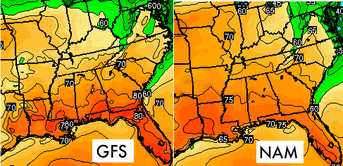
I am not saying that we won’t have a quick jump into the 60s again. I am just saying I don’t believe the very high end of the forecast.
A frontal boundary will likely sweep in for Tuesday and it has potential to bring a few showers into our area. This front is part of the reason that we see highs trend down toward the end of next week too. A big area of high pressure will follow this system into the region. It’ll tap some much cooler air during the process. This is that time period where I think we see highs trend below average for several days.
Another good push of moisture looks to arrive by late in the week. If this system had developed a couple of weeks ago it’d be one that we’d watch for potential snow output. However, this is a very different time in the world of weather.
A couple of looks from the European for rain next week. This actually tried to take a wintry look for next Saturday. It’s still picking up on signs that the cold air isn’t finished yet. We’ll just have to wait and see if it comes back around. You can notice in these snapshots that the old 540 line isn’t that far away at all. Not that I go straight by its position, it just tells me that colder air really isn’t that far away from this system.
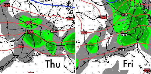
A little anxious to see if it will latch back on to a stronger low heading into the weekend. If that does happen it would certainly have enough go-go juice to wrap in some colder air on the back side. Just something for you to think about 😉
I’ll have another update for you later today!
Take care

It’s amazing how fast the weather can change. 70-80 degree temp swings in a matter of a couple weeks just blow me away.
What I find more interesting is Chris’s new writing style. 😀
I catch everything. You cannot hide! 😀
Chris,
In regards to your discussion of the 540 line, in my amateur opinion, it looks like it’s not only retreating back into Michigan, but it’s also getting much, much smaller. It looks like warm air advection is playing out on that model run, and honestly, from this perspective, it appears that this system would not be a snow producer.
“go-go juice”….is that legal? 😉
In most states…yes.
How old are you?
Spring is in the air
Valley Station – 1.84″
Louisville international – 1.83″
A little light rain falling. Main accumulation shutting down. Readings across Jefferson county were generally within my forecast range of 1
7 – 2.1″. However, eastern Jefferson county had reports approaching 2.50″.
The sound of warmer weather was nice to hear last night. All the sounds from the frogs and just being out after dark and it still feeling nice (outside of the rain).
Thanks for the update, Chris.
The confidence of “we haven’t seen our last flakes”, “winter isn’t over yet”, etc. certainly seems to have waned. GOOD.
The times of year where you really don’t need to do much to heat or cool your home is ideal after so many people struggling with high utility bills this winter (mid-Oct. to March).
This.
There are many signs of spring already out there. I defer to nature.