Good Friday, the fun in the sun is over as we are now tracking rounds of heavy rain moving across the commonwealth. This is why a Flood Watch was posted for a big chunk of Kentucky. There are a few counties missing from the watch in southern and eastern Kentucky. Here’s a look at that.

The zone that isn’t included will still see some rainfall and I even think that those locations will have a round of heavier rain or two to deal with. In my last long post I went on-and-on about the rainfall trajectory. That’s partially why those counties are not included in this watch. Our heaviest bands will most likely set-up along I-64. Stretching from Louisville to Ashland. That line could sway a little north or a little south. But I fully expect that to be the location of the heavier rainfall. Again… give a little wiggle room north or south.
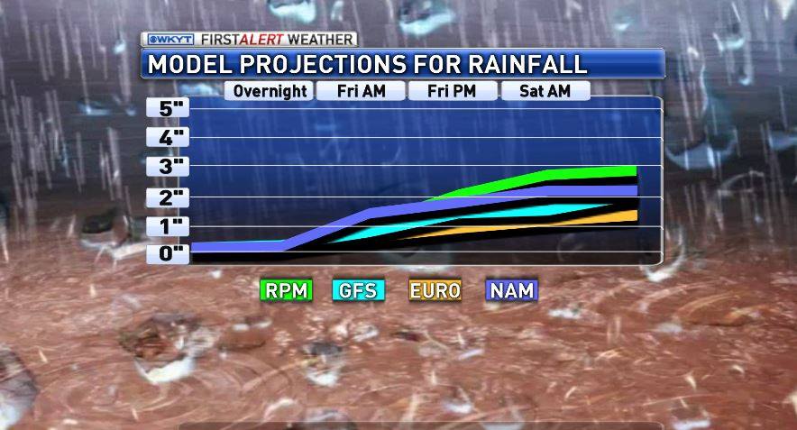
For days I have been showing what some of the model output was suggesting for our area. I had almost given up on some of the resolutions that they were coming up with. It was a battle back and forth on where the heavy rain would most likely occur. I was about to draw one out by hand when finally one run read my mind. Saved me a bunch of time drawing those layers on to a map. While it could still change some… I don’t think we’ll see significant changes to the forecast.
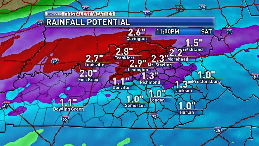
The only thing I would change is I might slide the 2″ plus line down slightly south of I-64. It’s rare that a run just reads my mind, but this one truly did. Maybe I am beginning to will these models to look how I want them? That’s a lot of water gang. Creeks will swell up quite a bit with this one.
I also threw this together to consolidate several of the models that I use daily. Some are under-playing the overall rainfall totals, but all are seeing these round of rain really coming together.
There will be an end to this system by Saturday night and into Sunday. Some cooler air will also try to filter in on Sunday as well. A quick drop into the mid and upper 40s will be a good possibility. That cooler shot of air will not be alone. Even more cool air will return into the middle and end of the week. If the timing can work out just right we will have some moisture passing through around the same time that our temperatures drop below freezing. We all know what that means… a few flakes. It’s a long-shot at this point, but I keep seeing those hints showing up.
As Always… here are all of your tracking tools.


Stay dry and Take Care

Starting today, I will be collecting rainfall for my upcoming garden. Looks like I will be off to a good start. I actually have a forecast of 1.7-2.1″ for my place in Valley Station through Saturday.
Looks like the heavy stuff might go north of the River. Northwest shift with rain. Usually don’t see that.
I am glad to see Knox County not in another flood watch or warning. We have had enough moisture for the time being. Hoping the rest of you all stay safe and maybe it won’t rain as much as is forecasted.
What a perfect pre-sunrise morning. Only birds being heard. Not too cool, but neither is it too warm nor humid. No dew.
Here’s hoping the sunrise can beat the green goblins that are almost upon us according to the radar.
Surprised I haven’t heard anyone talking about this yet. Somebody usually mentions this by the end of February. I guess I’ll open up the subject for the rest of spring.
Here in Lexington, I am already seeing buds sprout from the ground. Gras-s has already started becoming greener and buds are on some trees now! Everything here is starting to change waiting for the cold weather to leave. (Technically, they’re waiting for the sun to be higher in the sky and longer daylight.)
Great news, the latest drought monito has wiped out growing drought that was forming in our area. 51.46% of Kentucky was in moderate drought when it peaked on February 17, now 0% of KY is in drought, and 0% is abnormally dry!
http://droughtmonitor.unl.edu/Home/StateDroughtMonitor.aspx?KY
Forecast for Monday giving sunny and 75 …. wonder if we could hit 80 …. I love temps like that.
To me the most comfortable temps are upper 60s to low 70s with lower humidity.
I am most comfy between 65 and 80. Humidity is a bear in the summer.
Monday Monday, my year might dry…some…
Monday Monday, sure looks fine… Cross you fingers springers!!