Good Wednesday Evening gang. The “rounds of thunderstorms period” the blog has been forecasting for several days is now off and running. Many areas have been getting pounded today by heavy rains and even some late afternoon severe weather in some areas.
I am updating the latest warnings through Twitter which you will find here >>>>>>>>>>>>>>
You can also sign up to receive these updates free on your cell phone.
With many areas already picking up 1″ of rain… flooding is of concern over the next dew days. Here is a look at the latest Flash Flood Watches..
To be honest… all of central and eastern Kentucky through Thursday as more rounds of thunderstorms will bring very heavy rainfall to us once again.
For this evening… we have to watch for more storms developing across Indiana and Illinois. These could be working there way southeastward into the state. Track them here…
Here is the all inclusive severe weather map from the Storm Prediction Center for this evening…
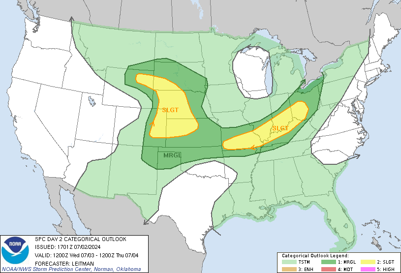
Some big time storms are likely to be across the area into Thursday with the threat for wind damage on the increase. Here is the outlook from the SPC…
Help out your fellow bloggers by reporting the weather conditions where you are. I will have more updates as needed. Don’t forget to follow the twitter link as well.
Take care.
Select Page
http://www.youtube.com/watch?v=TiFI4zFSFUY
my video as the storms moved through versailles.
Impressive cluster of storms along the stationary boundary heading our way for tomorrow.
http://www.hpc.ncep.noaa.gov/qpf/d12_fill.gif
Looks like storms will be much more widespread than today.
What’s the difference between an MCS and an MCC?
MCS- Mesoscale Convective System
A mesoscale convective system (MCS) is a complex of thunderstorms that becomes organized on a scale larger than the individual thunderstorms, and normally persists for several hours or more. Mesoscale convective systems may be round or linear in shape, and include systems such as tropical cyclones, squall lines, lake-effect snow events, and Mesoscale Convective Complexes (MCCs), among others, and form near weather fronts. They have been noted across North America and Europe, with a maximum in activity during the late afternoon and evening hours during the warm season (i.e. late spring and summer) on both continents. Mesoscale convective systems over the Plains of the United States bring the region about half of their annual warm season rainfall.
MCC- Mesoscale Convective Complex
A mesoscale convective complex has an area of cloud top of 100,000 km² or greater with temperature less than or equal to -32 °C; and an area of cloud top of 50,000 km² with temperature less than or equal to -52 °C. Size definitions must be met for 6 hours or greater. Its maximum extent is defined as when cloud shield reaches maximum area. Its eccentricity (minor axis/major axis) is greater than or equal to 0.7 at maximum extent.
You can thank Wikipedia for those definitions.
I should probably also add that an MCC is just an MCS with those set characteristics.
OK weather dudes….. been away from the blog for a while, but something I have been wanting to ask… What the heck are heating and cooling degree days? Hear it on my weather radio and dont know what it means. Guess I could google it but rather hear it from you guys!!! Had a pretty good boomer this afternoon in somerset, with all the rain chris has mentioned, it had actually become rather dry around here until today, we needed a drink!!!