Good Saturday and welcome to a steamy weekend. An increase in tropical humidity will help aid in the development of showers and thunderstorms. These storms will increase ahead of a cold front that moves in on Monday. That front could bring the potential for severe storms.
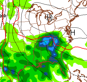
Scattered storms will be out there today and a few of these could be strong. The muggy factor is off the charts with highs in the mid and upper 80s. I will have your tracking tools in a bit.
Mother’s Day will feature more of the same with some storms and temps back in the 80s.
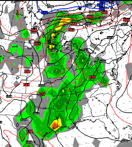
The severe threat will increase on Monday as a strong cold front sweeps in from the west. That threat appears to be increasing a bit and that’s something I will update through the weekend.
Temps behind that front will drop into the 70s on Tuesday and then into the upper 60s to low 70s for Wednesday and Thursday.
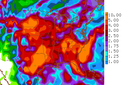
The models try to bring some heat back by next weekend, but they are doing so with a big increase in rain chances. The GFS for Friday…
The European Model is similar with a pipeline of moisture stretching back into the Gulf of Mexico…
The GFS continues to paint much of the region into a very wet and stormy pattern for the next couple of weeks…
 I leave you with some tracking tools…


Have a great day and take care.

Looking forward to the rain! My yard is cracked and dry.
Thanks in advance CB and other mets for keeping us safe from the possible upcoming severe weather on Monday. Looks at this time it could weaken a bit as it heads east but time will tell. Still need to be on guard.
Even though Nashville hit 90 yesterday, it was still somewhat of a dry heat with dewpoints only in the 50s. Fantastic sleeping weather last night 😛 , thanks in part to our home’s powerful – if old and noisy – whole house fan. But might soon need the AC with the increasing humidity. Anyway, stay safe everyone.
Good Lord – how could you not have used your AC yet? I’ve had mine on SEVERAL times. I must be a total light weight when it comes to AC…
With dewpoints today getting into the 60s and with friends and relatives visiting, we now got the AC on.
MarkLex, you are like my wife regarding AC! I on the other hand can edure the heat better than the cold. Last night, the outside air was cool with lower humidity. Our whole house fan in the hallway ceiling is so powerful, we sometimes tie down the drapes. Unfortunately, the metal louvers do a poor job of insulating from the cold during the winter. Thus, we are looking at replacing the current 40 or so year old fan with a new one that is much quieter and more efficient.
My wife is the first person to turn the A/C on in the neighbourhood and the last to turn it off. She’s no bigger than a minute. Temps outside hit 70 or higher the A/C is cranking. We get direct sunlight to our house from around noon till the sunsets. Great in the winter time. But extremely hot in the summer. We just replaced and upgraded our A/C two years ago so life is good now on keeping the house comfy. Plus we replaced our single Windows to double payne windows that’s held immensely.
Helps not held
MarkLex, we turned ours on yesterday evening. Well my husband did. I was still in the hospital. Have looked out the window at some gorgeous sunsets the past three days. So glad to be home for a few days. Chris thanks for the update. Been following the past few days and looks like the next couple are going to be fun. Anyway, enjoy the beautiful weather. Have a great Saturday evening everyone,
Coffeelady, sorry to hear you have been sick. Hope everything is better soon. Will keep you in my prayers.
Sorry to hear you’ve been in the hospital and hope all is well now Coffeelady.