Good Sunday, everyone. A cold front is pushing into the state today and is bringing additional rounds of showers and storms with it. This front will push just to our south as we head into the next few days, and that means cooler days push in. That doesn’t mean things will be all fine and dandy with our sky.
Storms our there today could be on the strong side across central and eastern Kentucky. Heavy downpours could cause some local high water issues. The greatest concentration should be across the east.
The front pushes through Monday and does slow down as a couple of waves of low pressure develop along it…
 Scattered showers and storms will still be possible, especially across the east and southeast. A similar trend should carry us into Tuesday and Wednesday. Yes, I know this is a little different from what I said in my last post… deal with it. 🙂
Temps during this time will be much, much cooler. Areas that get in on some clouds and showers on any one day may not get out of the 60s.
The latest signal from the models is to cut off an upper level system across our region and points south for the rest of the week…

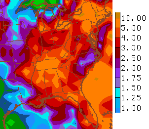
That would gradually warm our temps, but keep the threat for showers and storms going on and on. The GFS rainfall forecast for the week ahead…

The stormy signal keeps showing up as we expand the model rainfall forecast out to two weeks…
Are we setting the stage for a 3rd straight wetter than normal summer across Kentucky? The pattern suggests that, and normal to slightly cooler than normal temps, will be the case. With El Nino coming on like gangbusters… that’s the biggest factor pointing toward the wet and normal/cool summer. 1987 and 2002 are two years showing up on my analog list that kept me from going very cool and wet.
Let’s track what’s out there today…


Today’s risk area

Current watches

Possible watch areas 


Make it a great Sunday and take care.

Loving this cooler weather. My air conditioning unit has been broken all summer long and the Landlord still does not have it fixed. It sure has been hot so the cool weather is a blessing for me.
Not buying into the chilly rainy stuff……maybe a day or 2 here and there but overall hazy hot and humid. let’s see how it pans out 😀
As I recall, 2002 was a rather warm but not extremely dry summer around here.
It is what it is. Thank you and your still the Man Mr. Weather.
Thanks Chris. Was hoping for a couple of sunny days on tap. I guess we will just have to wIt and see. Have a wonderful Sunday everyone.
Not to be negative, but the GFS models are failing so far as the 3-5 inches for the last week of May has resulted to only a mere 1 inch or less in most areas in Southern KY by today’s May 31st date…still bone dry…could be much drier though like 2007 or 2002!
Getting very dry here in knott co. With all the rain chances last week we picked up bout 10 mins worth of rain
I think it comes down to the models being really off right now making forecasting more difficult than normal for late Spring. According to Chris the signals say wet yet I haven’t seen 1.50″ of rain this month. I’ll be interested to see if this changes in the next few weeks but at this point I am taking a wait and see approach. As usual I’ll be pulling for whatever the farmers what in this department.