Good Tuesday to one and all. Our tropical weather is missing just one thing… the beach. Steamy temps, high humidity levels and scattered showers and thunderstorms have been common of late. The tropical feel continues with an increasing threat for heavy rain producing boomers.
We are likely to see a decent increase in coverage of the showers and storms out there today as a weak cold front moves in. That front basically stalls out from west to east across the region and leads to waves of showers and storms. These storms could be strong and put down some hefty rainfall numbers for some.
That same setup looks possible for Wednesday and Thursday.
Our focus of the forecast for the second half of the week into the weekend is on what happens with the leftovers of our tropical system in the Gulf. Tropical Storm Bill will roll ashore across Texas and then slowly work northward through the Mississippi River Valley. That should then turn the corner and work due east into our region. Where that turn occurs is still in question.
There is likely to be a front draped across the region and that could help ignite heavy rain producing storms ahead of the remnants of Bill. The Canadian Model continues to point toward that scenario…
Leftovers from a tropical system interacting with a front can spell all kinds of trouble where that occurs.
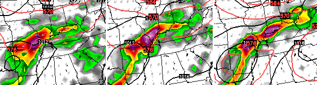
To track the pure leftovers of Bill, I’ve pulled out the PWAT map from the GFS. What the heck is a PWAT? It stands for Precipitable Water and is a cool way to measure the amount of water in the air. You can clearly see what’s left of Bill rolling across our region…
Areas along the path of that system will have to deal with some very heavy rains and flooding. Will that include Kentucky? Stay tuned.
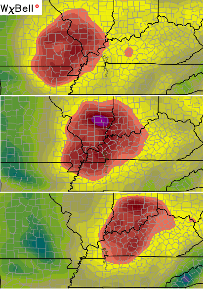
I have you all set to do some tracking of what we have out there today…


Today’s risk area

Current watches

Possible watch areas 
Have a great day and take care.

I’ve only been to the beach a couple times in my life, and none of my visits included sticky, smothering air like we have around here during the summer.
Wow, I don’t know where you went to the beach, but I lived in FL for 14 years and every time I’ve went to the beach in the summer, its a lot worse than here. Dewpoints don’t go below 70° from around May to September, and even longer in So. FL. Highs in the 90’s for 5 months straight. The only possible relief from the heat is if a tropical system hits, then highs are only in the 80’s but it’s still muggy.
Yeah, have a relative that lives in FL and have visited many times. Always muggy it seems. And I have not really considered this to be very bad. At least in the areas I have been. Especially at my place. Not even super hot really.
It’s funny though, because I think KY’s state record high temp is higher than FL’s. It’s the duration of heat down there that makes it worse. I think it can get actually hotter here during rare heat waves but it’s constantly hot down there for the most part during the summer.
I think it’s all matter of opinion some folks say Florida summers are hotter than Ky others say Kentucky summers are hotter than Florida. Me personally I go with the family to Panama City Beach once a year and will be doing so in late August. I think during the months of June, July and August, Kentucky heat can rival with Florida maybe not dewpoint wise but air temperature, yes. Being that said Alabama in my experience there heat and humidity is just down right overwhelming and oppressive in the summer months. Alabama in my opinion takes the award for dewpoints and temperatures.
It is the heat and humidity and such that get me. I can handle 90 and lower humidity, even 95 or 100. But that does not compare to 85 or 90 with the very moist air. Hard to cool down once you get hot. Sweating just does not help. And I will not even mention anything over 90 with high humidity.
I think the worst I ever experience was as a teen when we went to Texas for a while to visit a friend of my dad. It was not only 100+ but the air was so moist you could see it. And they were advising people of it. All we did was sit under the tree in this guys yard until late. Was 80’s fairly late into the night. Not sure how low it went but it was 90’s very early each day quite a bit.
The TV mets where I live in Northern Ky are suggesting the front will lift back to the north some by Thursday, although the chance of showers/storms will still be present. In other words outdoor activities have a less chance of happening today and tomorrow.
Also saying “Heavy Rain” for Saturday but that sure could change I would think.
I wish we had Minnesota’s weather right now. Widespread 40’s this morning, and highs in the 60s and 70s all week.
While temps were already soaring into the low 90’s in Knoxville, we were standing at the observation tower of Clingman’s Dome 6,643 ft high and the temperature was only 70 degrees at 1:00 pm yesterday.
Thanks Chris. Israel, bite your tongue!!! I annoy saying a bit of cooler air wouldn’t be nice but I am not ready for fall temps yet. We haven’t even hit the “official” start of summer yet! I’m still enjoying the warmth, and looking forward to the garden goodness!
Chris do you think the front will stall or move back North? I will acknowledge we need some rain here. Oh well we can’t control the weather. (Not even Chris can control it. He is just the BEST when relaying the patterns!)
Have a great Tuesday everyone!
Meant to say I am not saying, not annoying. Ha! Heat must be playing with my brain!
Ok, the rain is just teasing me now. I was outside doing some work and the dark clouds start rolling in. Some thunder. Then a nice cooler breeze and you could tell it rained. Just not here. So close.
Texas heat is hot. Im notva fan of texas heat, last time i was there last summer, temp was 97 heat index was 117. First day i about roasted, after being used to ky temps of the 80s.
A little rain will be nice . Ill take rainy afternoons all week if i can get it. Garden could use it.