Good Monday, folks. Our tropical pattern rolls on with high humidity, toasty temps and scattered storms. This action will hang tough through the middle of the week and may get a true tropical kick in the pants later this week. While all this is going on, there are subtle signs of changes showing up in the longer run.
Highs today should be able to get into the upper 80s and low 90s across the entire region. The only thing that would keep this from being the hottest day, so far, would be a little more in the way of storm action. These continue to look scattered, so prepare to sweat. 🙁
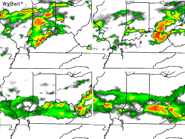
The threat for storms should increase some later tonight and into Tuesday. The simulated radar from the NAM…
There’s even the potential for some strong storms to go up during this time. Something similar may set up for Wednesday.
From there, we have to wait and see what happens with the tropical system in the western Gulf. That system is going to work northward through the Mississippi Valley and then turn the corner into the Ohio Valley. Areas along and near the patch of what’s left of that system can expect some very heavy rainfall. Will that include Kentucky? That’s the question I have to tackle in the next few days.
Here are the latest track forecasts from some of the tropical models…
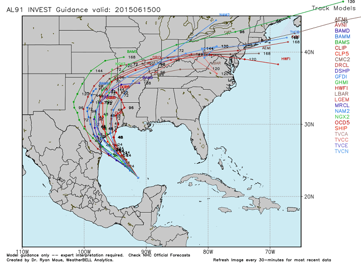
Those are updating every few hours, so chances the map already looks different from the version you see above.
The Canadian Model has been the most consistent with development and track of this system. It’s been all over this for days now and takes the storm right over us…
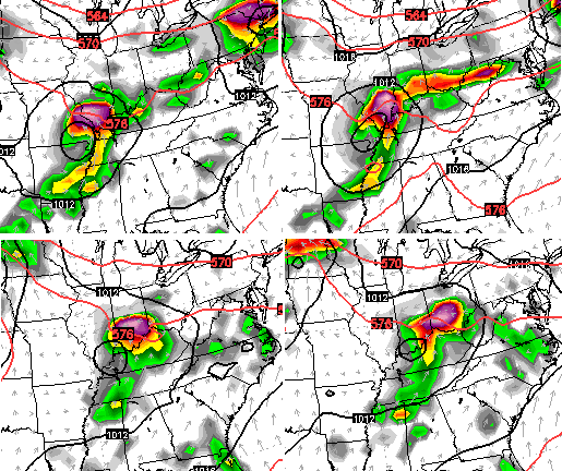
Looking farther down the road, the models are suggesting some changes in the pattern. Here’s what the setup looks like right now on the European Model…
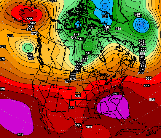
And here’s what it looks like early next week…
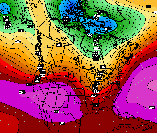
Notice the trough digging into our part of the world. If that’s real, it would bring much cooler air into the eastern part of the country…
The strengthening El Nino argues for more troughs to dig into the eastern half of the country as the summer wears on. That should also crank out better storm chances and the CFS continues to advertise this through July…
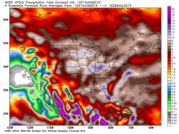
Again, this El Nino isn’t your typical El Nino, so let’s see how things work out.
I leave you with your tracking toys for the day…


Today’s risk area

Current watches

Possible watch areas 
Longest post in blog history? Have a great day and take care.

It looks like SE KY is going to miss all the much needed rain but not the heat–only time will tell! I am always excited to track and see where tropical systems go; it will be a fun week indeed:)
I think you’re right CB…it really may be the longest! But we certainly appreciate it. Those of us that like to look weeks and even months in advance definitely appreciate it!
Really hoping we can get some soaking rains into the state this week. My part of the world in Lawrenceburg needs it so badly and I know most others do too.
Also, it looks like my wife and I are headed into a monster of a heat wave as we leave on vacation for the coast of Georgia and Florida later this week and then eventually the Bahamas the following week. Toasty looking forecasts down there for sure!
JJ my family is in Pensacola this week and the weather is very nice but we have had a red flag on the beach the last few days.
Back when I followed this blog in the winter…during a winter storm Chris would post lots of traffic cameras from all across the state making any one of those blog posts much longer than this one.
It does take a while to scroll through all of the radars and severe weather tracking stuff though. All of that info is appreciated by me.
Thanks Chris. I don’t mind the longer posts. I find them interesting. On the prospect of rain, I wouldn’tind some as we are getting a bit dry here. Question….when you say “much cooler” temps, what do you mean? I am hoping it only means temps in the 70s, and nothing lower. As far as JAJTeach is concerned, he’s getting ready to leave on vacation, so his opinion doesn’t count! (JK John Allen)
As it is, it’s a beautiful if hot day and sunny. Right now we are already at 83 here at the house. Stay hydrated my friends, and not thirsty! Have a great Monday!
Heat index already in the 90s at 11am. Ouch.
Only about 1.50″ of rain total at my house since late April. Sorry, Chris, that is short-term drought conditions. I don’t care how wet it was 2-3 months ago, it dries out very fast this time of year. The southeast ridge is a killer right now. Here’s hoping the tropical moisture makes into the state later this week.
After humidity in the 45% to 50% range the last little bit today it is currently at 77%. High or 88 and feels terrible. I have been out working on some stuff the last few and today it is just to muggy and the sweat just pours. Then we have a downpour for about a minute or 2 and then sun. Went out to get the mail and the steam made me think I was in a sauna. Terrible day and could have done without the rain at my place if that was going to be the extent of it.
Enjoying these tracking tools. Saw the radar and called a friend who lives in the northern part of the county. They are getting a good rain. Which is nice.
Storm just north of my place again. Can hear the thunder and see the clouds but just missing.
Chris….any updates on Bill’s track and how that may or may not affect our weather in Central, KY? Thanks…..WW
CPC says what eastern US trough, and cooler temps? The 8-14 day outlook shows the southeast heat ridge holding strong. Take it for what it is worth.
Yeah, seems a lot of the rain was sort of missed for many. And then the heat for me has not been as high as I have seen predicted. Even a day out from some places. So there is that. Crazy how this has played out.
Models have been terrible lately–I agree! I don’t see the cool down coming next week either as most other forecasts are not showing this eastern dip in the jet. Without widespread rain, I think we are heading for a much hotter summer than the past couple of years for sure!
I don’t understand what the southeast ridge really is quite honestly. I know sometimes there are heat ridges, like there will be a ridge in the plains with storms riding around the ridge, etc, but there’s no real name for those ridges, just a ridge in the plains. But then if there is a ridge in the southeast, it actually has a name….What is that about? Is it just a southeast ridge because it happens to be in the southeast? If there is a ridge in the southern plains, why not call it a southern plains ridge?
I guess Bermuda High is a better term, but this ridge is displaced more to southwest. Temps in Georgia have hit the 100’s, so this heat ridge has legs. Fascinating how storms fire on the periphery of the ridge. Unfortunately, KY is within the ridge, and higher heights, so a capped atmosphere / subsidence has meant only weakly formed, and isolated showers and thundershowers the past several days. Looks like this ridge might get suppressed just enough to bring better rain chances into the state as the week goes on. Fingers crossed.
6 straight days of 90+ temps for Louisville officially. 94 for high temp in Louisville today. Louisville has had more 90 degree days than Atlanta Georgia so far. That’s pretty impressive considering how very wet we were in the early spring tells me the moisture content at the ground is getting overwhelmed and drying out quick by lack of rain and hot temps. We all need a good soaking rain to transpire this week hopefully that will happen.