Good Sunday, folks. It’s another day of steamy temps and scattered showers and thunderstorms across the commonwealth of Kentucky. These kinda days have been common of late and it looks like a few more are on the way. While this is happening, some tropical action is trying to get going in the western Gulf of Mexico, and that could eventually impact our weather.
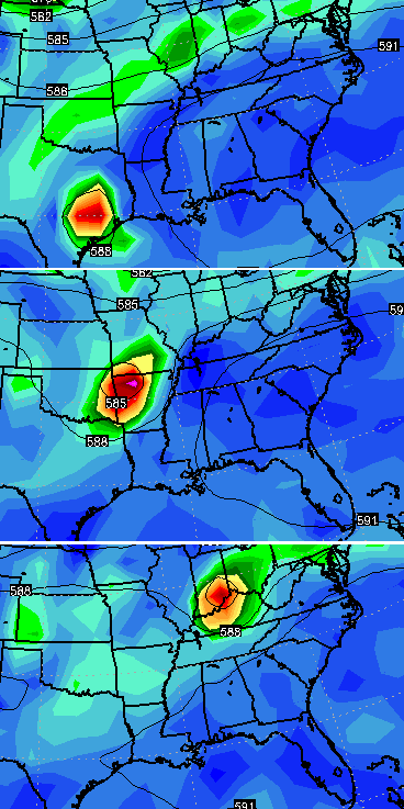
It was around a week ago that the European Model first hinted at some tropical development in the western Gulf. That solution is looking more viable by the day as something could spawn down there over the next few days. The models are then taking whatever type of system develops and swinging that energy into our region.
Follow the path of this on the European Model…
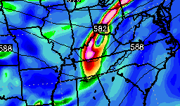
The GFS and Canadian Models also bring that energy into the Ohio Valley…
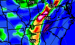
Areas along the path of that energy will likely have to deal with a lot of rain. Here’s the Canadian depiction of where that occurs…
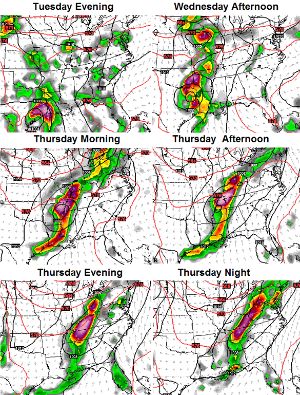
That is certainly something to keep an eye on as we roll through the next several days. If the models above are correct, a swath of very heavy rains may set up across our region before the week is done. It’s all about what develops and the exact path it takes once inland.
In the meantime… let’s track to scattered storms we have out there today.


Today’s risk area

Current watches

Possible watch areas 
Have a great Sunday and take care.

We’ve been expecting rain here in Lexington for several days and not a drop. What’s the deal?
I’m a-s-s-uming not enough lift in the atmosphere even with all of the heat and humidity. Hopefully that will change in coming days with more lift.
Thanks Chris. Only downside I can see to the current steamy weather is that I don’t have a pool in the back yard! I know it’s been rough for people who work outside but at least we are having some semblance of a typical summer. I remember last summer a few folks were complaining about not being able to keep the pool water warm.
It’s gorgeous out there this morning. Get out and enjoy! Have a great Sunday everyone!
Desert conditions in frankfort, need rain bad
In NKY, we have brown yards all over the place. Need a good soaker for a couple of hours. Where do we order that up, Chris? Ha!
Based on today’s comments, Chris may need to dial up another rant after only 8 days…
https://kyweathercenter.com/?p=14636
Saw the RANT and parts of Kentucky are “abnormally dry” according to the Drought Monitor. It’s very dry whether it’s a “drought” or not. I can get my fingers into the cracks in my yard. It’s DRY.
I didn’t say anything about a drought. I just said that we have brown yards, which is a sign of going a few days without steady rain. That’s all. So let’s calm down? Yeah, let’s calm down.
We definitely did not receive the GFS rainfall predicted several weeks ago, but Chris is an excellent weather forecaster just the same…need more rain in SE KY as we did not get the excessive rain Central KY got back in April!
It is getting a little dry in spots, but nothing earth shattering.. It always seems to balance out around here. I would imagine July or August will turn wet.
I for one would rather it be abnormally dry than to have rain and flooding everyday.