Good Saturday, folks. Our first weekend of June is feeling the part with warm temps, humid conditions and the threat for scattered showers and storms. Our storm chances will really ramp up by Sunday night and Monday as a strong cold front moves into the region. Some of those storms could be severe.
I’ll get to that in just a moment. First, a RANT ALERT
Now that it’s summer, I’m seeing the usual suspects talking about “drought” and dry conditions. Stop. Please… I beg of you. It’s silly. Every single summer it’s the same thing… we get dry for a few weeks and people yell DROUGHT. This happened last year and the year before… Yet, both were among the wettest Summers on record for parts of the state.
It’s happening again because May came in drier than normal. Guess what? That drier than normal May was a GREAT thing because we desperately needed time to dry out after the flooding/record rains of February-April.
Even with the dry May, look at how far above normal we are across the state since January 1st…
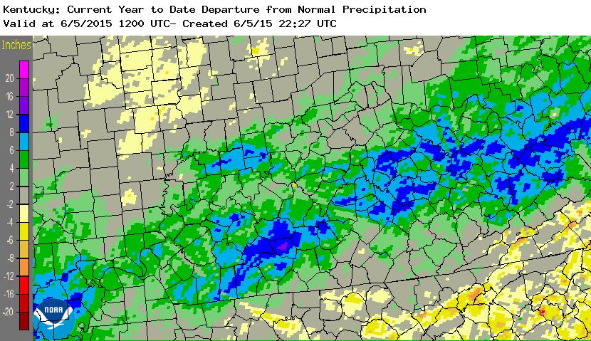
The numbers from the official reporting stations…
Lexington: +6.54
Louisville: +3.70″
Covington: -1.97
Bowling Green: +1.63″
Jackson: +3.88″
Ashland: +1.69″
Paducah: +3.71″
The data speaks for itself. Calling every dry spell a drought is beyond ridiculous and is partly due to the “let’s lower the bar and call everything a drought” Drought Monitor Index.
I promise your grass will lose color at times this summer… that’s what grass does around here when the days get longer and the temps turn up. Ok… Rant over. 🙂
The rest of our weekend will feature a mix of sun and clouds with scattered showers and storms going up. Highs will stay in the 80s.
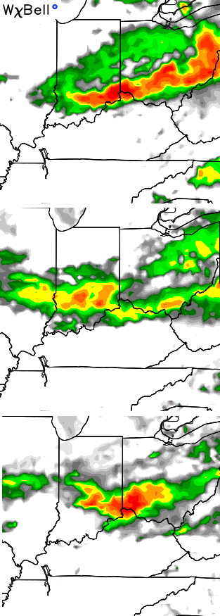
Our cold front arrives on the scene late Monday with rounds of showers and storms developing ahead of it by Sunday night. The NAM simulated radar shows the first wave moving in…
The same model run then shows a more potent line of storms developing by late Monday afternoon and evening…
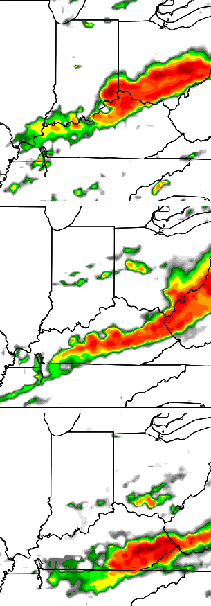 Some of the storms could be on the strong or severe side and bring heavy rains into the region from Sunday evening through Monday evening.
That front would then put the brakes on with the potential for scattered showers and storms coming at us at times through much of next week.
I leave you with a daily dose of tracking tools…


Enjoy your Saturday and take care.

Love these Rants…It shows you really care about the fear mongering that ends up taking place from those who are slaves to their tools instead of relying on instinct and common sense.
Its been dry for all of us lately, I hope Todd has been getting his rain on pace with everyone else so far this year. I remember people calling drought last year and the year before, those were probably the same people that gave up on winter when it wasn’t even over yet, and look at the past two winters. This goes to show that don’t as-sume one thing when its not even over yet.
Thanks Chris for the update. I don’t think we’ve had too little or too much rain. My only complaint about the weather has been that we seem to get fronts that want yo hang around with the cloudiness. While that is good too at times, it’s summer. Let’s see the sun!☀️
By the way, thanks for yesterday’s nice weather. I enjoyed celebrating our 39th anniversary with a beautiful day! This morning looks like it’s going to be a carbon copy. Have a great Saturday everyone, and thanks gain Chris for all you do. (And rant all you want, I agree with you on this one!)
Happy Anniversary!!! May the Lord Bless you with many more! Enjoy the sunshine!!
Ditto with the anniversary wishes, CoffeeLady 😛 ! Perhaps a few lucky couples among us will mark half a century or so!
Great weather in Bowling Green (so far) as the better half (wife) and I join the in-laws there for the big Aviation Heritage Park fundraiser.
http://aviationheritagepark.com/hangar-party/
https://kyweathercenter.com/wp-content/uploads/2015/06/Radar-Rainfall.jpg
This NOAA graphics map makes me wonder if they also provide them in Minecraft style as well?
Nice rant CB. I’ve also been pleased to have a break from months of soggy yards.