Good Saturday, everyone. Rounds of showers and thunderstorms are getting ready to increase as we continue to tap a tropical connection. These storms will likely ratchet up a bit as we head into next week, and that could lead to some heavy rainfall concerns.
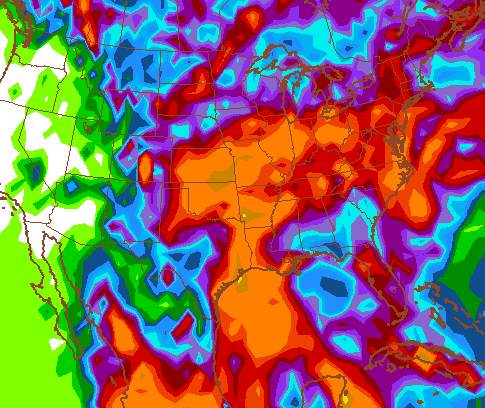
Our moisture supply continues to come from the western Gulf Of Mexico. A few of the models continue to indicate some kind of tropical system developing in that area. The GFS and Canadian Models both bring whatever is there our way for the middle and end of next week.
Here’s the Canadian model…

The GFS rainfall forecast shows a similar path of tropical moisture…
The longer range is advertising some changes with a deep trough showing up across the central and eastern part of the country. This happens as a ridge gos up along the west coast into Alaska…
 That’s basically the pattern we spent much of the past few years in.
Back to the weather of today… storms will be around with more seasonal heat and humidity. Any storm that goes up will have a lot of lightning and very heavy rains. Let’s do some tracking…


Today’s risk area

Current watches

Possible watch areas 
Have a great day and take care.

Thank you for your recent discussion in regard to fall and winter forecasting. For me, winter is a two sided coin that I both relish and dread. Again thanks for all of your weather forecasting work. It is greatly appreciated.
Does not seem to be too bad yet. Nothing amazingly hot and humid. Mid to upper 80s with around 50% humidity is not that bad.
Do wonder how this all plays out for the fall and winter. Looking forward to more insights on the rest of summer as well. Glad you have this blog and really appreciate what you do.
It is if you hate heat and humidity. LOL
I wish the temps would stay in the high 60s all the time during the summer, but that’s not happening..
Thanks Chris. We have been watching the radar for a possible quick hitting storm but it has dwindled to a hard rain shower with a little wind. Just enough to either cool it off, or make it hotter and more humid. The clouds being around have helped with the instability as well. Will not be the least bit upset if we can get a little rain.
Appreciate all you do. Have a great Saturday everyone!