Good Friday to one and all. We continue to run with a seasonal brand of heat and humidity across our part of the world. The humidity is getting to us much more than actual heat is. Highs will continue to flirt with 90, but some thunderstorms are going to start to crank.
We will likely fire up some scattered showers and storms out there today. With a little more in the way of clouds and storms, temps are likely to come in under what you had on Thursday. Many of us may only reach the mid and upper 80s.


High temps over the weekend should range from the mid 80s to low 90s depending on where you live and the amount of storm action. A few clusters of storms will be floating around and that makes for some difficult temp forecasting.
Thunderstorm clusters are likely to increase into next week as our pattern continues to throw a ton of tropical humidity our way. If you look at a rainfall forecast through next week, you can trace the juice all the way back into the western Caribbean…
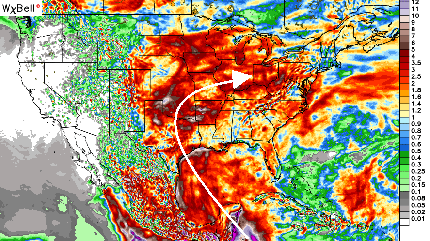
Expand that out to the next 2 weeks and you still see that connection with the threat for storms growing across much of the eastern half of the country…
 As I’ve said, this is a very atypical El Nino developing in the Pacific. To be honest, I’m still trying to get a handle on the impact it will have for our summer weather. Analoging this summer is a tough one and that likely spells a tough time with the fall and winter forecast. That’s why I’m starting way earlier than normal this year. 🙂
Enjoy the day and take care.

Ahhh Fall and Winter… just the thought of it puts a smile on my face. Let’s get this Summer heat and humidity out of here!
Let’s not
Thanks Chris. Looks like another warm one for sure. Just going to enjoy what we get and find something good in each of them. In the heat, I remember how cold winter was, and in the winter, I will remember these warm sunny days. Have a great Friday everyone!
…… Any sign of a drought?? Just kiddin’ CB! 🙂