Good Thursday to one and all. We have one heck of a humid stretch of weather on the way to the bluegrass state. This tropical air will be joined by seasonally hot temps (at times) and the increasing threat for showers and thunderstorms. It’s a pattern locking in for a while.
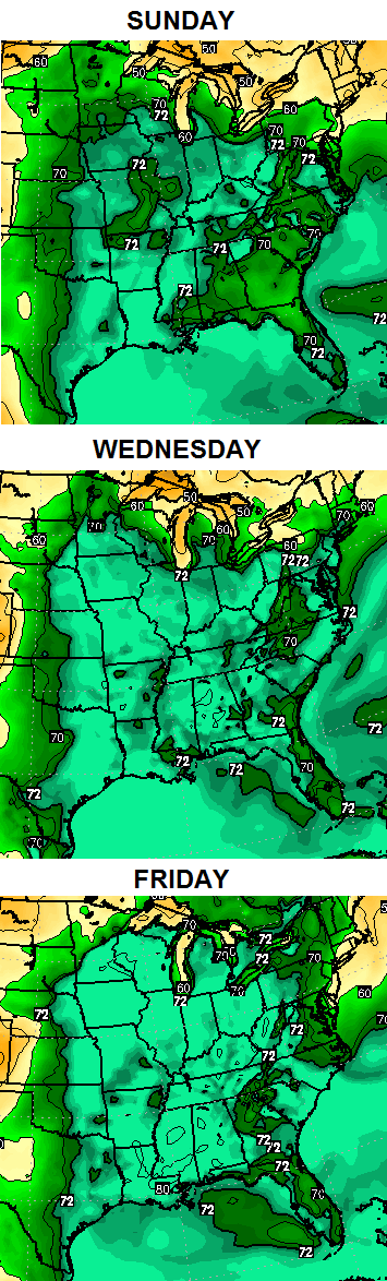
One of the ways we measure the amount of moisture in the atmosphere is through the dewpoint temperature. Generally speaking, anything above 65 is rather humid. Once above 70, things really start to get juicy and oppressive.
Our dewpoint numbers hit the low 70s at times over the next few days and that’s a sign of things to come. Check out the tropical moisture kicking in this weekend through next week…
 You can see how the tropical connection coming from the western Gulf of Mexico. With a developing heat wave to our south, that’s going to put our region in a zone with seasonally hot and humid weather with rounds of storms. It’s a zone that crank out some healthy clusters of thunderstorms that put down tremendous amounts of rains for some.
The European Model is showing this threat well…
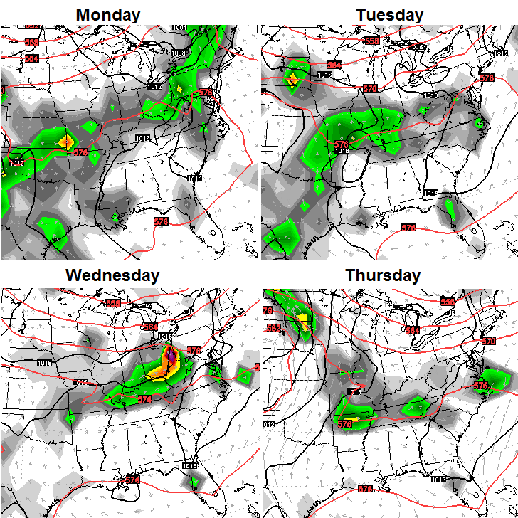
That’s something to keep a close eye on as we roll forward.
How about the weekend forecast? Scattered showers and storms will be around with steamy temps. Sunny days where you live means 90 or so. A storm goes up and you can forget about even being close to 90.
The threat for storms actually begins today with some isolated stuff out there. Temps will be around 90 for many. Track away…


Have a good one and take care.

I have always thought that you need a trigger for storms to develop, more than just heat and humidity. I wonder what triggers isolated storms on a hot humid day?
I’m sure KU will be happy people will be using their AC’s a lot. On the bill they sort of shame you about how much electricity you use, but they secretly love it!
Just recieved my energy profile thing from KU last week. They were bragging about how low my energy use has been lately… I’m sure that over the next couple months they will change their tune.
From WKYT weather page.
“Heat will remain in place though next week. It doesn’t really show any signs of stopping at that point either. Take it easy out there if you have to be out in this heat!
Today’s Forecast High: 90
Tonight’s Forecast: 69
Normal High: 81
Normal Low: 60”
This is literally the opposite of the modeling discussed at the beginning of the month about June being cooler than normal (and July as well). CB, you seemed to agree with those at the time, or you certainly didn’t ridicule them for being wrong, so what do you think happened with the data that lead to such a disparity between expected and actual? How were the calculations in that so off that they began being untrue almost immediately? Is there that strong a bias in it?
Unless we have some snow at the end of the month, June is going to be very above average because even if the highs are tempered by rain, the lows have been really high as well. It shouldn’t be an uncomfortable post mortem because CB didn’t do anything wrong, but he can shed some light on the wonky modeling.
You do realize June is running 2 to 3 degrees below normal, so far… right? 🙂 Last week featured the coldest June highs in almost 50 years.
I like the sunshine and a few storms but I feel like I just paid the last electric bill below $100 I’ll see for a bit. But hey, it’s Friday Eve! Have a great day everyone and thanks Chris for the update.
Coffeelady, ha! Me being obsessed with AC my bill was NOT under 100 dollars. It was more like 130! It’s funny, because I remember when I first moved into this house in 2004, the KU bill would always run like 60 or 70 dollars. I don’t ever remember it being overly expensive, until the last few years…..The only time it’s low is early spring and late fall when no HVAC is running. Don’t get me wrong, electricity is worth EVERY PENNY! But it’s gone up so much in the past few years.
mine was about 130 too. so much better than the 500 I paid last winter. my fav months are when nothing runs. I was able to squeak out just under 100.
Bailey, your tweet cracked me up. we just might melt! and to think I have been running around town with the top down on the jeep and all the windows open. feels fantastic!
The high today in “Covington” was 92. Feels great. Especially compared to that nonsense from the first week of March.
Also…this time of year my HVAC bill is running about $57-58. However last winter I topped $200 one month. I obviously could take some additional actions to bring that number down but bottom line is my bottom line hates winter and so do I.
Ahhhh…Hot Muggy Weather! Like it’s supposed to be 😀 No snow no cold fronts no frost no wintery crapola
Corn, beans, tomatoes….all happy.
Hot and Humid…ENJOY IT PEOPLE!!!! There was snow on the ground just 3 short months ago and we all couldn’t wait until summer. Happy Weekend!