Good Wednesday, everyone. Temps are set to take off as humidity levels soar and that spells some sweaty days ahead. This tropical air mass will also lead cause scattered showers and storms to increase as we roll into the weekend and for much of next week.
Let’s start with the temps part of the program. Highs today will reach the mid and upper 80s for many with a low 90 possible across the west. Upper 80s and low 90s will be possible across the entire state on Thursday. From this point on… temps will continue to be steamy, but daily highs will be dependent on storms around.
If you have storms where you live this weekend into next week, temps will obviously be held down. Any day that doesn’t feature storms could see some low 90s bubble up.
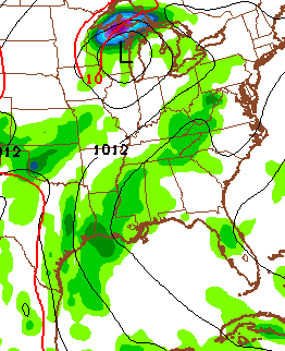
That said… it does look like scattered storms are going to go up each and every day. There’s even a small threat for a storm or two bubbling up out there today…


Scattered storms will flare up on Thursday afternoon, but the models show better coverage of the storms possible on Friday…
 If we look at the 10 day rainfall maps from the European Model, we notice a couple of things…
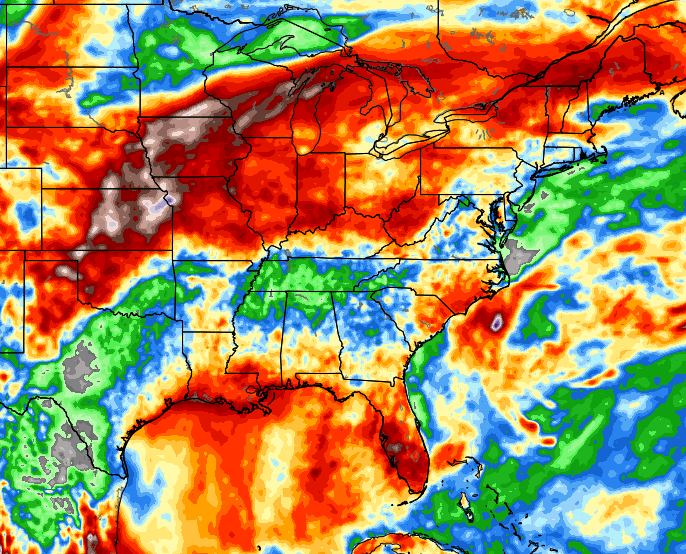

It’s showing the axis of heavy rain shifting into the plains states and then eastward toward the Great Lakes and Ohio Valley. That’s a stormy setup with the potential for some healthy clusters of storms developing and moving our way. You can also see where the core of the heat sets up across the Tennessee Valley and south… not much rain falls there.
I said this last night on air, but the pattern ahead has “cloudburst” written all over it.
Make it a great day and take care.

Thank you Chris. Have a great day.
But if you go by what the GFS is saying a developing heat wave is in the beginning stages. Canadian model says no real heat wave. The rest of the models seem to be on the fence.
I think I’ll take a walk everyday now, the summer’s gonna show me the way – to be happy now, I just can’t stay inside all day, I gotta get out, get me somma those rays – It’s a sunshine day 🙂