Good Thursday to one and all. Our stormy pattern keeps on keeping on across the bluegrass state of Kentucky. Heavy rain and storms have been common and it looks like that’s going to continue to be the case in the coming weeks. Record rain numbers are possible before this summer is over. Heck… maybe some yearly records?
We continue to see a front draped across the region today with an area of low pressure moving along it. That means more in the way of showers and storms will push in from the northwest. Locally heavy downpours are still a possibility. Temps should continue to run below normal for many.
Yet another system works our way for Friday. That keeps a boundary around into Saturday and could give us additional rounds of showers and storms…

Heavy rains will be possible (shocking) with these storm clusters rolling in. Outside of the boomers… it’s going to be super steamy! Humidity levels will be crazy high with heat index numbers that climb for areas getting in on some sun.
A dip in the jet stream early next week is likely to ramp up the rain and storm chances even more…

That system could cutoff across the region for the middle and end of the week…
The end result is more heavy rain numbers and high water issues…
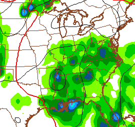
 I leave you with your “I’m tired of seeing these” tracking tools…


Today’s risk area

Current watches

Possible watch areas 
Make it a great day and take care.

Mehh
Hey big surprise its raining again this morning lol
be careful of what you ask for…….back in may and early june there were a few people on here screaming drought and chris posted a rant about the very same thing…….so we go from a “possible drought” to record amounts of rain fall……such is the weather in ky. and surrounding states……make it a great day.
I hope we’re out of this wet pattern before winter. Can you imagine if this were snow?
I saw a little article the other day that pictured a snow pile in Boston…. It was still there, as a big chunk of trash covered ice… I think the article said that at its highest, the snow pile was 75 feet tall, or something like that…. I guess thats a reminder that no matter how bad we think we have it with all this rain, we’d better be thankful, because it could always be worse.
Rain, rain go away…but come again another day.
This is becoming the Summer Without Sunshine. When it’s not raining it’s overcast. When it’s not overcast the sun is obscured by haze from Canadian/Alaskan wildfires!
About to get interesting in Berea
checkin in!!!! goodnite