Good Friday to one and all. The stormy setup we have going on right now across the commonwealth is nothing less than amazing. I’ve said for years that extreme seems to be the new normal around here and this summer is backing that up… again. I really can’t find a break in this thing and next week has me a little concerned.
Before I get to that, we have storms to contend with today. Some of these could pack a punch with local wind damage and high water the main threats.
Scattered storms continue this weekend as steamy temps take over. A 90 in the west and south is possible, with other areas mid and upper 80s. The high humidity levels could make it feel close to 100 degrees at times.
This takes me to the setup that has me very concerned for much of next week. A heat ridge builds in to our southwest as cool air surges into the Great Lakes and northeast. That puts Kentucky in a zone of potential BIG thunderstorm clusters…
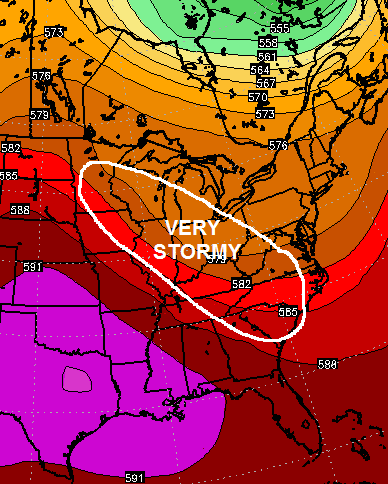
Complexes of thunderstorms may develop well to our northwest and roll in here starting Monday. Severe weather and flash flooding will be possible on daily basis next week.
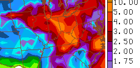
The rainfall forecast from the models should be sounding alarm bells in the weather world…
GFS
European
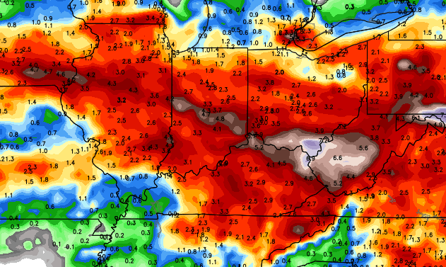 Given how wet we are and the models agreeing on storm clusters diving in here… watch out. The potential is there for serious flash flooding in parts of our region next week.
Let’s track what’s out there today…


Today’s risk area

Current watches

Possible watch areas 
Have a great Friday and take care.

http://twitter.com/Kentuckyweather/status/619350048971837440
Well Ill be on St. George Island, Florida from Sunday thru Wednesday morning, so Im afraid the Dome will leave my part of Kentucky putting it at further risk of Severe Weather. You’ll have your work cut out for you.
Hey Chris, does the EL NINO has anything to do with this wet pattern were in or . I don’t recall such a wet summer were having so far and I been on this earth a while.
Persistent pattern…west is hot, east is relatively cooler, storm track in the middle…and we’re in the middle.
I just read an article saying that this El Nino will hold until 2016. Article also suggests that this area is drier than normal for fall and winter. But if the pattern holds like this due to the sustained El Nino and other factors I wonder if that is the case. Looking forward to any early insights CB might have on what he thinks it looks like for fall.
Got a feeling the Southeast U.S. will be a winter wonderland this winter..Thxs to possibly a super El Nino..
Thanks Chris. Wow! Too much of a good thing? Must admit I am missing some of those dry hot sunny days. Maybe we can work a few in in the next little bit. Anyway, it’s Friday!!!! Have a fabulous Friday everyone and stay safe!
I need some sun for my garden!! all this wet is making it sad.
Mesonet site registered 47 mph gust from near Hardinsburg with this storm complex…clouds darkening here in Valley Station with moderate to heavy rain and a few rumbles of thunder.
Good to know the Mesonet is back up. It was down for at least a couple days.
I’m tired of this pattern.
Holy crap – that line does not look good at all. The bowing looks like it’s moving right to my area. That storm the other day the wind scared the crap out of me…..UGH
Yeah. R.I.P. Lex going by the arc on that radar atm
Actually, I can’t believe it, but this wasn’t NEARLY as bad as the wind that took the trees down the other day. But that radar looked as if it would be worse, at least that is the case in my back yard. Yes, it was very windy, but not nearly as intense as the other day.
We’ve had two huge trees fall in the past two weeks so the Friday storm sent me to the hall with the vacuum cleaner roaring to drown out the wind. When I finally got brave enough to look, there was nothing happening but heavy rain. Whew!!
Our absolute worst storm was early July 2001. I hope we never get another one like that. The farms out here in Bourbon County lost hundreds of trees because they had cut down all the cherry trees due to the MRLS with the caterpillars, and they exposed the other trees to full force wind.
I’d love to get through the summer without being scared every day.
oh yay! more storms……..
We had wind gusts at my house yesterday at around 2:00, at 57 mph knocked down a huge wild cherry tree.
Not that I want a storm to hit I am just curious. How come storms generally break up as they near eastern and southeastern ky?
Mehh