Good Saturday, everyone. I want you guys to go outside and take advantage of today’s decent weather across the bluegrass state. We have a small break in our super stormy pattern, but it’s not going to last very long. Rounds of strong and severe storms return later tonight into Sunday.
This is the setup I’ve been trying to sound the alarms on for the past several days. We’re going into a pattern that will cause big thunderstorm complexes to develop to our northwest. Those storms will then routinely roll southeastward into our region.
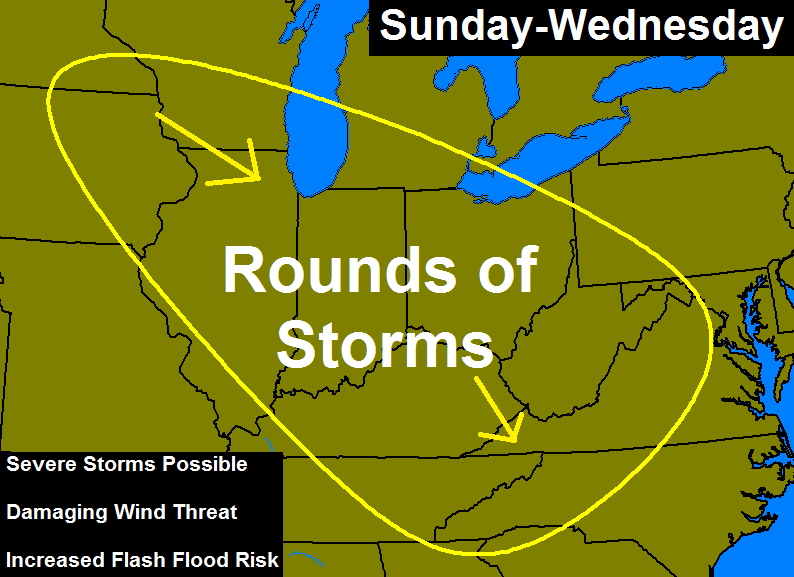 Here’s a breakdown:
– The types of storms that develop are usually damaging wind producers that can have a long life span.
– Storms that develop hundreds of miles to our north and northwest could hold together and impact our weather.
– These rounds of storms will also be prolific lightning producers.
– The flash flood threat is going to really be high during this time. Our wet ground can’t hold a much additional water, but my fear is we have a lot of water on the way.
– I’ve said it on air for several days now… I just don’t like the looks of the setup in the coming days.
As I said… Remember to enjoy the decent weather we have out there today…


Have a great day and take care.

Hi Chris, thank you for your excellent weather forecasting that you do for the people of Kentucky it is appreciated. I have a request that I’d like to see you address maybe in a future post or additional mapping.
I’ve been wondering for quite sometime about how the high level jet stream affects our severe weather as it rolls In. I seem to recall a day we had some tornadic activity around here with the storms coming from the south. You mentioned where the high level jet stream was at as well as the speed of it. It seems to me that the high level jet stream really caused our storms to start rotating. I’d love to hear your thoughts as to how the high level jet stream affects our central Kentucky weather.
I like when Chris goes into detail about the way weather works.
D E R E C H O?
Have you ever heard people in SE KY call it a “durr-ekko”? It’s actually pretty amusing to hear in conversation. I’ve ended up liking that pronunciation over the correct one.
If we all looked, spoke, and acted the same the world would be a very boring place! :o)
Amen
I hope not. I never understand why some storms have so much lightning while others don’t. For example, yesterday, when that bow shaped storm moved through, there was a ton of wind and rain, but I heard very little thunder. Other times, you can get a storm that has lots of intense lightning. It’s like storms can look equally intense on radar, but one will have a LOL and the other won’t.
So, am I correct in saying that these storms will have lots of rain and wind but no hail???
Raining still in Bowling Green this morning!
I saw that Becky. Looks like one line little storm and it’s moving southeast to almost due south. Bhopal it doesn’t last long for you.
Thanks Chris for the update. Hope we see some sun today s we need to get our lawn mowed before the monsoon season comes back and it’s awfully wet! Even when we don’t gave rain we can’t seem to get consistent sunshine. Oh well. Going to get out and enjoy the day. Have a great (and hopefully dry) Saturday everyone. Tried thus a bit ago and it wouldn’t post do if I wind up with a double, I apologize!
I know CB’s Twitter is often spammy with mundane weather pics but there are often gems too. Nice work by the photographer!
http://twitter.com/Phil_JKD/status/619679167412576256/photo/1
Still amazed at that line that came through Frankfort and Lex with such a strong radar arc. It just kept reforming to the same shape again and again after it would start to weaken and lose cohesion.
I think it made it through half of WV before it finally stopped doing it.
I agree with too many pics. To the pic taker some pics seems like rough skies, but seems not so much to me. It is to the point I do not even open a lot of tweets. I do like some of the pretty scene shots, but still adds to the stack.
Some are good pics though and good weather intel 🙂
Considering it is Chris and his Staff that RT/Fav pics that are submitted to his @Kentuckyweather handle on Twitter, I wouldnt be so bold to call the pictures “Spammy” or “Mundane” Im just glad that he responds to his viewers in the fantastic fashion that he has over the years!
You can turn off retweets on Twitter. That way you only see what he actually posts, not what he rt’s.
The RTs are not really spam at all.
Chris, we need some good news man!!!! Bad news started with all the snow and now rain all summer long.
then you might not like this winter either 😉 Well, by then if it is bad I will be this: 🙁
This is what I love about CB and why I’ve followed his blog and forecasting since I was very young. He started talking about and making people aware of this upcoming severe weather event several days ago. This morning as I logged onto the Internet and social media sites, other mets are just beginning to really talk about it. He does a phenomenal job forecasting events several days in advance and isn’t afraid to call it out before other mets mention a word.
Thanks for all you do Chris to keep us informed! You’re the best hands down.
It’s miserable here in BG this afternoon. Heat index is 99.
Always seems hotter in BG that Lex area.
Don’t mean to sound like the little boy who cried wolf one too many times, but there is an infamous analog showing up for this Monday, July 13. Anyone remember the hurricane force derecho of 2004? Guess what the date was for that one?