Good Sunday, everyone. We’ve arrived at the time we have to be on guard for a heightened risk for damaging winds and flash flooding. Complexes of thunderstorms will roll across the state today and through the next several days. These will be very capable of causing issues across Kentucky and surrounding states.
The first cluster rolls through here early today and could bring severe weather with it. Once that rolls through, we will have to watch for additional storms to fire up this afternoon and evening.
Another complex of storms should form to our northwest tonight and roll our way into early Monday. The next potential set of storms is the one raising the alarm bells for me. That may dive in here late Monday into Monday night and bring the potential for widespread damaging winds and tornadoes.
The Storm Prediction Center already has a MODERATE RISK for severe weather on Monday…

Additional thunderstorms will likely fire up on Tuesday. Once again, the action comes at us from the northwest.
Each of these storm clusters will produce a tremendous amount of lightning to go along with torrential rains. The rain part of this is bad news for an area already waterlogged from weeks of heavy rain. The NAM is showing my fear… Several inches of rain falling on some areas through Tuesday…
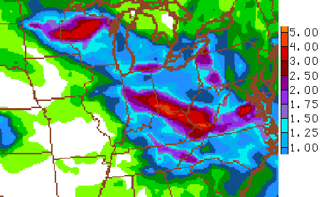
The actual placement of the heaviest axis of rains will vary depending on exactly where the storms travel. But, that’s a wicked look for just a few days. Hopefully we can get Flash Flood Watches posted early today to give advance notice of the potential ahead.
Your Sunday storm trackers…


Today’s risk area

Current watches

Possible watch areas 
I will update as needed. Have a great day and take care.

Chris
I notice after Tuesday the daily storm threat goes way down in the 7 day forecast. Do you think once these storms are done, the pattern will be changing?
Thanks
Louisville getting pounded with heavy rain and lightning. Rainfall rates of 2-3″ per hour.
I follow the various “Lost/Found Pets” Facebook pages in the Lexington area. These loud booms of thunder send dogs and cats running in terror. I’ve got two poodles on my lap right now and they both just jumped as the house shook.
The snow lovers got their wish in Feb/March and now the severe storm lovers are getting their wish.
Mother Nature, here’s my wish — sunny, calm, and 73 degrees. 🙂
Some cats/dogs, but not others. I have 2 cats. One is terrified, the other will sit at the window with close lightning popping, wind, hail hitting windows. She doesn’t care at all.
That’s why shelters have their biggest influx of new animals around the 4th of July each year. It’s traumatic for many animals and not just the domesticated kind. Then there’s the situations of vets who had more than their share of combat. All of those issues and more for such very little positive social good.
If you’ll compromise a little on the amount of clouds (Simpson’s style where lots of small ones all the view without too much burning) and a nice breeze then that’s one of my favs as well.
While it is mainly the threat of damaging t-storm winds and some localized flooding the next few days for areas from Wisconsin to our area, a grim anniversary is also being marked. Hard to believe it has been 20 years since much of the central USA endured a severe heat wave that left nearly a thousand fatalities. Although cities like St Louis, Milwaukee, Madison (WI) were hard hit, Chicago alone had about 750 deaths.
http://en.wikipedia.org/wiki/1995_Chicago_heat_wave
What made this heat wave so exceptional was that it had both extreme temperatures and extreme humidity. In some cases, high temperatures in the mid-100s combined with dew points well into the 80s.
– – – – – –
Thanks CB and other mets for looking out for us, especially over the next few days. Everybody be safe.
St Matthews in eastern Jefferson county with nearly 3.5″ this morning.
My house in Valley Station ‘only’ 0.48″
Four miles from my home in SW Jefferson only got 0.11″
Had family who lived in VS and we always used to get less rain and less snow there than in immediately surrounding areas. The theory was it had to do with the stench from the HS. 😉
Me having family that lives in Valley Station the one thing I’ve notice in my years either Valley Station gets hit hard or Valley Station gets a glancing blow to nothing at all.
I know how you feel. It stinks to barely get missed on the rainfall, especially if you have the storm go right through your county! I am sure you will get a better rainfall before this week is over. Right now, the storm complex appears to be a dead-on hit for my house in a couple more hours, but time and time again, I have watched both complexes and individual storms either fall apart or barely miss my location as the mountains really tear apart the worst of almost all storms before reaching me!!!
I’m tired of this pattern.
It looks like this pattern is going to step up a notch the next several days.
Heat index already in the mid 90s at 9 in the morning? For you folks in west ky… Ouch.
Preliminary look at Tuesday’s chances for severe storms appears higher than Monday’s. I have not seen what the SPC is saying yet.
You were looking at it before they updated. You were looking at day 3 when that was really day 2 or whatever I’m saying. You know what I mean.
Keep us posted! Thank you Chris !
What do you mean by “real heat” CB? It’s 88 in the Metro with a heat index of 95. That’ real heat to me. It’s freakin HOT! I don’t like hot. I like 70’s year round.
88 isn’t real summer heat. That’s normal. The humidity is the killer.
70’s even in January??? That’d make 2 of us! 😉