Good Thursday, folks. Waves of torrential rain producing showers and storms continue to push across the bluegrass state. These storms are packing some amazing rainfall rates and that can easily cause additional flash flooding in parts of the region.
Here’s a breakdown of the forecast:
– Heavy rain producing showers and storms will continue through the evening for much of the region.
– A few strong storms will be possible during this time.
– Rainfall totals of 1″-4″ will be possible across the state by Friday morning. Locally higher amounts can occur.
– Leftover showers will carry us into early Friday, but better weather moves in through the day with highs in the upper 70s and low 80s.
– Saturday’s weather looks great with temps in the low and middle 80s for many.
– Isolated showers and storms may blossom Sunday afternoon as another system dives in from the northwest.
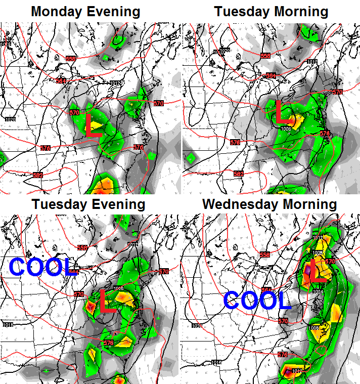
That’s another potent system that moves in here from Monday into Tuesday with additional rounds of showers and storms. Much cooler air will follow that up…
 Once again, that’s a pattern that doesn’t look very much like the dog days of summer. But, it fits the pattern I’ve been yapping about for the month of August. 😉
I leave you with your daily dose of tracking tools…


Make it a great day and take care.

Here’s an animation of El Nino 1997 compared to this year’s El Nino…Notice the cold pool of water in the Gulf of Alaska in 1997..We don’t want the cold pool to develop like 1997..If it does could be a boring winter..
http://sealevel.jpl.nasa.gov/layout/ostm/elnino2015/1997vs2015-animated-800.gif
Good read from wsi about potential blocking this upcoming winter..
http://www.wsi.com/blog/traders-things-that-make-you-go-hmmmm-regarding-the-upcoming-winter
Usually, it is preached that strong El Nino events will yield a milder, drier winter for Kentucky and the Ohio Valley region, but I don’t think this will be the case with this year’s El Nino event. Could you imagine how wild and stormy this upcoming winter could be if we have both a strong southern jet interacting with a strong northern jet over the Ohio/Tennessee Valley region???
Early signals are pointing toward another fun winter around here!
Bring it on, Im getting out of outdoor work starting in a couple weeks anyway!
🙂 Mutual feelings. I love extreme weather, especially snow storms!