Good Thursday, everyone. There isn’t much more I can say about how awesome this pattern is. Our taste of September sticks around for a few days before some changes start to move in for the weekend. These changes will eventually lead to some scattered showers and storms.
Today is rather simple… Highs will hit the upper 70s to low 80s with a mix of sun and clouds. Perfection comes to mind.
Friday will see readings bouncing back into the 80-85 degree range for many with similar conditions expected on Saturday. There is the smallest risk for isolated showers and storms going up both days. The NAM:

With a weak trough across the region this weekend into early next week, the potential is there for more scattered showers and thunderstorms…

From a temperature standpoint, this looks to feature near normal temperatures in our region.
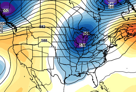
A much more prominent dip in the jet stream develops across the plains by the middle and end of the week. The models are struggling with how much of that swings eastward into our region. The runs go back and forth on just how cool things COULD get late next week.
The Canadian Ensembles certainly have a cooler look…
 While, I do think the overall pattern begins to skew warm again late month into early September, some transient cool shots are still very possible.
More winter talk is on the way in the coming days!
Have a great day and take care.

Thanks Chris. I wish I could take this afternoon off to enjoy the perfect weather but unfortunately I had last Thursday off work and you guys may remember how that turned out. 🙁
Thank you Chris. Have a great day