Good Monday, everyone. The boring and dry weather days are now in our rearview mirror and we’re looking through the windshield at a very busy pattern as we drive toward October. This means periods of very wet weather and blasts of chilly air are ahead.
Some areas will see a scattered shower or thunderstorm going up today as moisture streams in from the deep south. The system down in the Gulf is just way too strung out to fully develop, but it will send a surge of juice our way on Tuesday. That will interact with a cold front sinking in from the north and produce widespread showers and storms.
Watch how the showers and storms increase on the NAM…

1″-2″ rains are possible for some areas with this kind of setup.
The NAM and GFS take that system off to our north and east on Wednesday with leftover showers around. The new Canadian Model ups the ante for heavy rains by keeping this system right on top of the region through Friday…

That model run spits out better than 4″ of rain through that time period. I’m not saying that’s right, but it certainly bears watching.
The GFS waits for a second piece of energy to drop in a few days later, blowing up another slow moving storm just to our east….

Some of the recent model runs are showing one heck of a shot of chill with this type of setup…
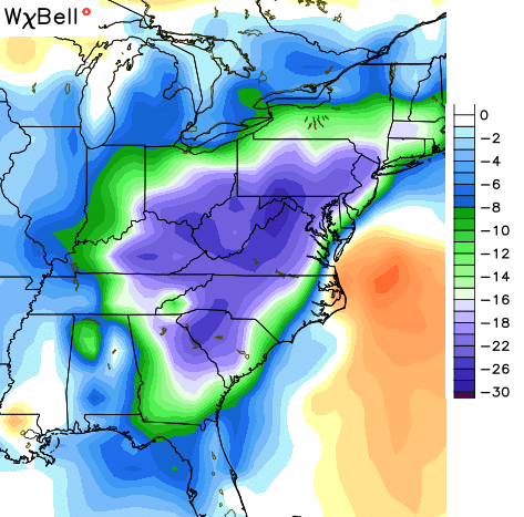
The exact evolution and placement of that east coast storm will determine just how chilly things get around here. Regardless, cooler than normal temps look like a given as we roll into early October.
From there… we will likely see this active setup continue with even colder shots of air coming!
I’ve been trying to bang the drums for the past week on the potential for this pattern to really crank up. That appears to be happening.
I leave you with your Monday rain trackers…


Make it a great day and take care.

Thanks, CB!
It will be interesting to see how this fall’s severe t-storm/tornado season will pan out in our area (which tends to peak in November). Thankfully, the SPC feels any thunderstorms in KY and TN the next few days will likely stay below severe limits.
Have a good week everybody.
Thanks, CB.
Do you think we could get some snow this fall.
?
MODEL MADNESS begins!!!! weekend forcast up in the air..
Still calling for an old school Winter, Rolo?? 😉
Can’t wait to see the battle of the southern jet and northern jet. I hope we get some bombs this winter:)
Chris, we have our Regional Girl’s golf tournament tomorrow at Keene Run near Nicholasville….starting tee times 8:30-10:30….what is your thought on the amount/intensity of possible rain for morning/early afternoon.
…thanks for all you do…
have u ever heard the tale if u have a lot of fogs through the summer each one counts as a snowfall for winter?