Good Friday, everyone. We have a strong cold front blowing across the bluegrass state today with gusty showers and thunderstorms. This is introducing us to a very busy weather pattern cranking up for the rest of November. It’s a pattern that will throw a system our way every few days and will try to take on a more wintry look later in the month.
The line of showers and storms moving in early today will likely weaken the farther east it gets. Winds will be very gusty and could approach 35-40mph at times.
The cold front won’t actually sweep across the state until late afternoon into the evening. I’ve seen situations like this fire up another line of storms. The best chance for that will be in the east and southeast, and is something to watch for later today.
Showers linger into southeastern parts of the state Saturday as chillier air pushes in. Skies become partly sunny from northwest to southeast during the day with highs mainly in the 50s.
Sunday looks like a great day with a frosty cold morning giving way to sunshine and low 50s.
Scattered showers develop and move in from the south on Monday with highs back in the 50s. That begins an active week of weather with a stronger storm system impacting us Wednesday through Friday.
The new SST Constructed Analog Forecast for the winter is out and it shows no changes from what it’s been saying for the past several months. It continues to show colder than normal weather around here…

The model also shows a very active southern storm track…
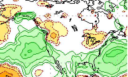 That would imply a lot of bowling ball type systems from California to the Carolinas. For snow lovers… that’s a good look for this region.
I will have another update later today, for now, let’s do some shower and storm tracking…

Current watches

Possible watch areas 


Enjoy your Friday and take care.

I go with your winter call CB!
Enjoying the nice weather. Has been just right for me. Hopefully this active pattern is not very nasty. But it is about time for the muddy yard to take hold for a long while.
Definitely looking forward to some snow this winter. My 3 year old is sure to love it too. Hope we can get a good one a few times.
These fronts always die before they reach us folks down here in southeast ky.. Pike and Letcher mesonet hasn’t even measured.
Very dry in Harlan County. Rain dried up before reaching me today. Hoping tonight will bring a little bit before the dry air moves in this weekend and forest fires become an issue.
Also, I am hoping this new pattern change next week will treat ALL areas in KY equal as I am sick of the state being so divided on who gets decent rain while other areas get basically nothing…strange year…