Good evening, everyone. Wild temperature swings and high water producing rains have dominated our Sunday. It looks like more of the same is on the way for Monday as a big storm system rolls up the Mississippi River Valley.
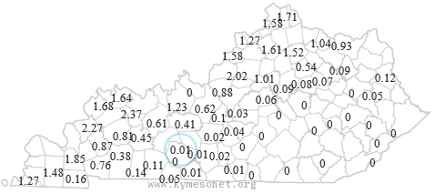
Today’s rains, as expected, have been concentrated across the west and north. Check out the totals through 6pm…
 The ground is saturated and can’t hold much more, but we have more on the way into Monday. This is an impressive storm bringing more showers and storms our way…

That band of showers and storms will have a lot of moisture to work with and could put down another 1″-2″ with locally higher amounts. The Storm Prediction Center says to keep an eye on far southwestern parts of the state…
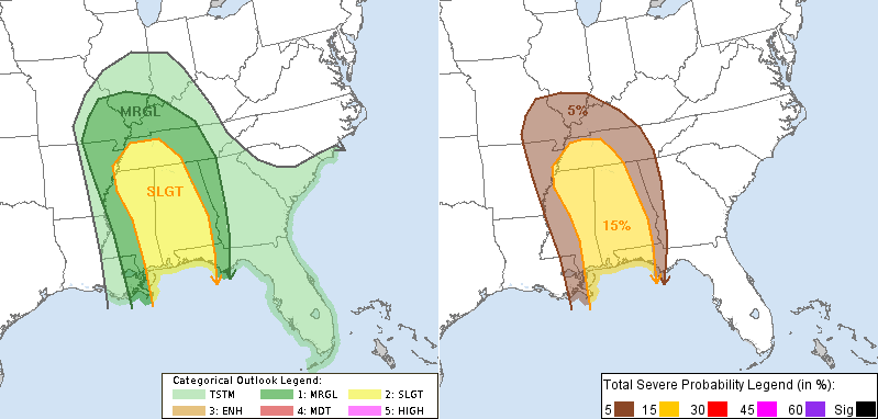
The worst of the severe weather should be to our south, but a few big boomers could come far enough north to impact the west and southwest.
High winds will be an issue Monday into Monday night. Those gusts may top out at 40mph or greater.
Ready for another wild temp ride? Giddy up…

We will still have to watch one more potential rain maker on Wednesday before colder air blows in to usher in the new year.
I leave you with your tracking tools of the evening……


Enjoy the final hours of your Christmas weekend and take care.

Thanks Chris. Wow! The old adage about hanging around for the weather to change in Kentucky might need to say instead “just drive to another part of the state!” Be safe and careful out there fellow weather lovers. Have a great rest of your evening.
Loads of rain in Richmond yesterday… None at all today… The cutoff line as sees on the Mesonet is amazing! Interesting December weather – certainly not boring…
They could use that rain in Ventura, CA right now!
Video of a hwy about 10 miles outside the city
http://i.imgur.com/xepKpew.webm
Needs more guy playing guitar, though.
Look forward to the colder temperatures and maybe some snow in the near future.