Good afternoon, folks. I have no changes to the arctic cold front moving in here later tonight into Tuesday. This is going to bring a round of snow to the region, and will introduce another blast of bitterly cold temperatures.
I will let my earlier snowfall forecast stand with this update…
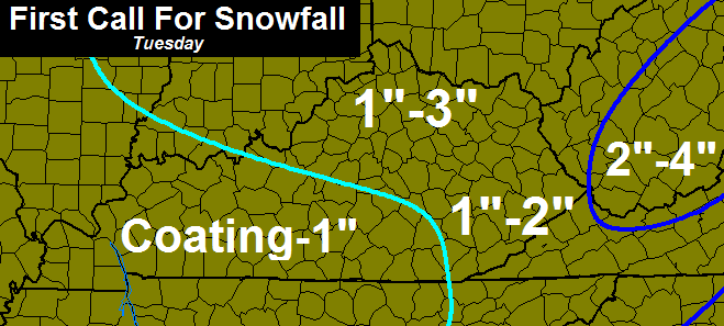
The final call will come later today, but I’m not expecting too many changes to the overall ideas.
Winds will be very gusty and create some blowing snow. While this isn’t a lot of snow, it will create some hazardous travel conditions as it sweeps in. The timing on this is going to make for some tough calls for area school systems. It may not be snowing by the time some districts have to make the call, but will likely start not too long after that.
Temps behind the fast-moving snow line will drop into the teens Tuesday evening. Single digits show up by Wednesday morning…
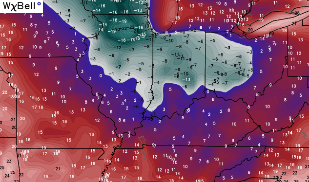
Wind chills will go below zero during this time.
The weekend still looks to feature another storm system working across the region with rain to snow as temps crash. This takes place Friday night into Saturday with wraparound snow showers and squalls through Sunday…
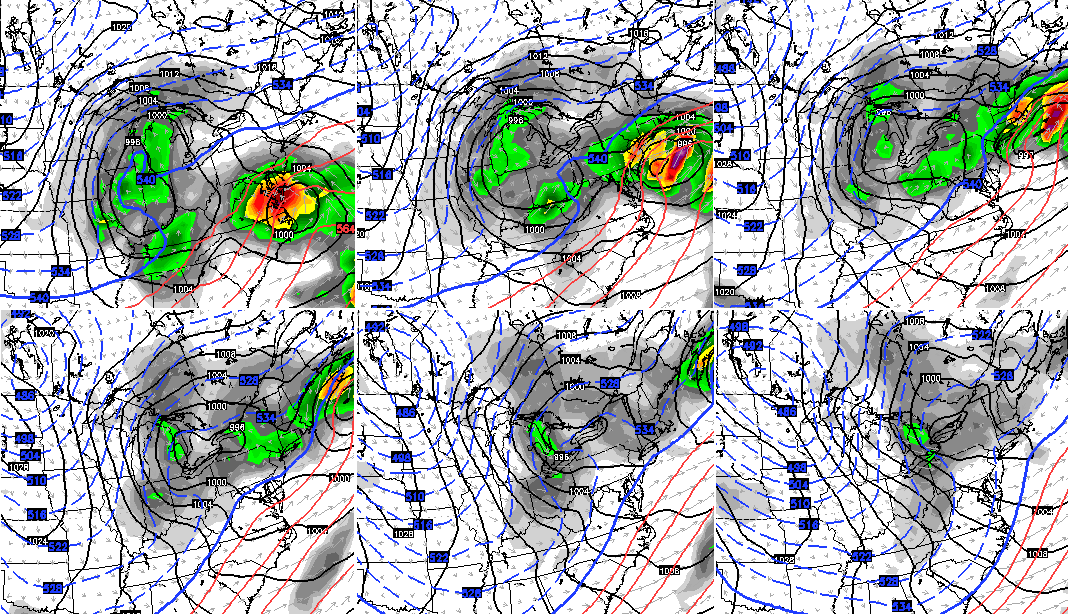
There is another piece of energy coming from the southern jet stream that may move across the Tennessee Valley late Sunday and Monday. With arctic air moving in from the north, that would be another snow maker.
Another update comes later this evening, so check back. Until then, track away…


Enjoy the afternoon and take care.

Hope the School Systems will be weather aware!
Hopefully tomorrows forecast works out. Wrap around for Saturday usually not good for accumulation, probably about like yesterday.
Alot depends on the timing and wind chills in terms of schools IMO. Think CB will have a much better sense this evening as to timing and if we will be on the low or high end of the range although might be tough to predict until the middle of the night. I think he should have an indication at least by late tonight.
Snow squalls are a now casting event computer models do not handle these events well at all. You get underneath a heavy snow squall 2 or 3 times in same location you can have 2-3 inches. Drive down the road and nothing at all. No real way to tell where the heavier bands of snow squalls will form.
Ha! The fancy radar has “too many connections…” message on it right now. It’s all these school teachers and students that have the blog on “rapid refresh” right now :).
Oh yes! And count the bus drivers in too!
Yes! Without a doubt, bus drivers are at the top of that list.
Glad to atleast some snow falling in January, we all know what happens in February, sun angel gets high and snow is only around a short period.
I remember it seems like it took a long time for last feb 17 inch snow to melt. I remember they were going to start fining people who didn’t scrape their sidewalks….
Last year’s first big snow definitely stayed around forever. I definitely remember the last of the first round melting literally the day of the second which was two and a half weeks after that snow fell. But yeah, as a general rule it does melt a lot faster.
Thelma Lou says it’s a shame that Wayne County wasn’t in the WWA….missed us by that much! She says they should add us in just for kicks.
Has Bubba or Rolo weighed in yet?
Enough to cause slick roads, but (as usual) hoping the winds reduces the amount of slick areas. Mother nature blow dry 🙂
TO MUCH DRY AIR, as with most clippers the precip along and north of it. DUSTING at best for Lex south and se. nothing to see here. the clipper way north so don’t count on missing school.
Are you a bit under the weather? You don’t sound too Rolo-ish!
Just the usual Rolo flip-flopping. *yawn*
Rolo brings up what I’ve been wondering about…do we have to worry about dry air and moisture saturating a gazillion layers of atmosphere? I hate refreshing the radar and seeing all the blue when it’s the dreaded “V” word. Yes, I said it. Virga. The enemy of snow luvrs everywhere. It stinks to have snow hopes waylaid by the meteorological phenomena of dew points and dry air.
Lets hope for an overachiever, I’ve seen these northwest clippers do this in the past 🙂