Good Monday, everyone. We have a strong arctic cold front ready to blast the bluegrass state with bitterly cold temps, gusty winds and accumulating snows. This is likely to cause a few travel issues late tonight and into Tuesday.
Our day is starting with single digit thermometer readings into much of central and western Kentucky. The American forecast models just do not understand the depth of the cold air already in place and the bitter cold on the way. I’ll spare you the rant. 🙂
The arctic front dives in here early Tuesday with a healthy band of snow along and behind it. We may actually see some light snow and flurries breaking our ahead of this front later tonight. The future radar from the Hi-Res NAM shows some of the light stuff before the squall line of snow sweeps in…
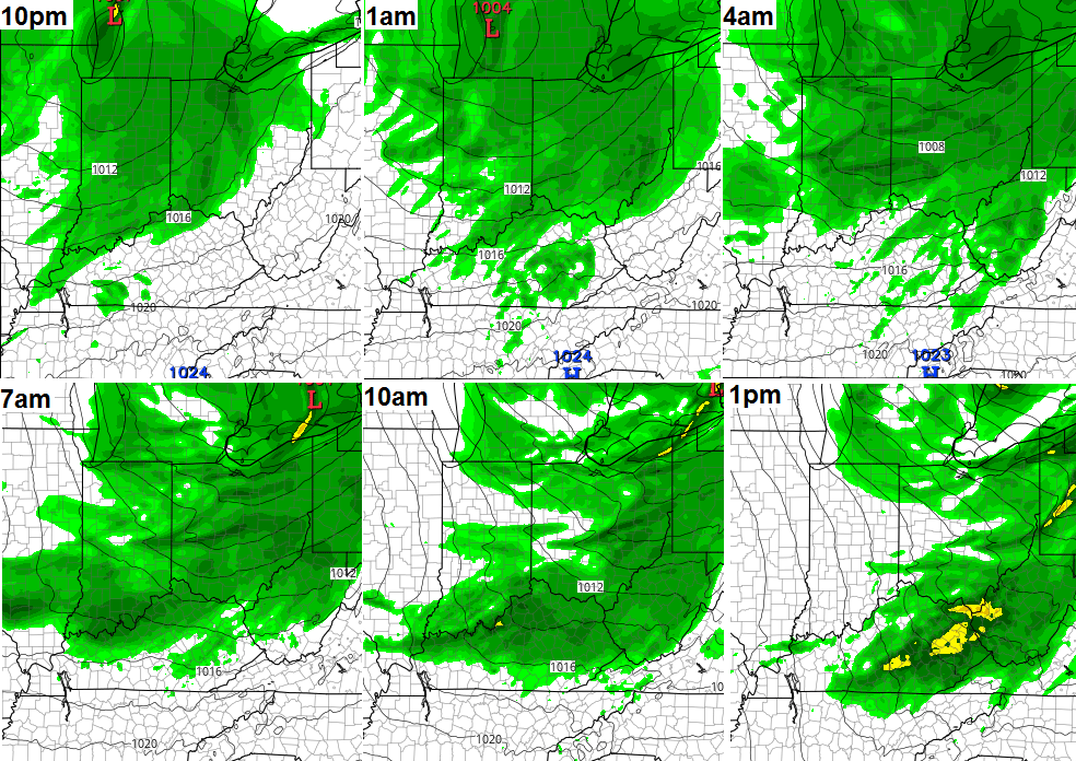
The convective nature of that line can lead to thundersnow (which was first talked about here nearly a week ago) and high winds. That combo can cause some travel troubles as it blows through here.
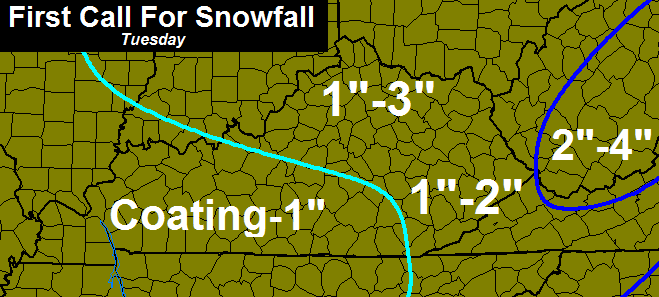
Pinpointing how much snow falls out of one of these lines is a little tricky, but so is every snow forecast. I anticipate many 1″ amounts along this line, but it has the possibility to drop some 2″-3″ totals in a hurry. Here’s my First Call For Snowfall…
With 30-40mph winds blowing, it won’t really matter if you get a half inch or the high end of that scale… It will impact travel.
Temps will spike a bit just ahead of the front then come crashing down right behind it. We’re back in the teens by early Tuesday evening and we keep dropping from there. Temps by the time you wake up on Wednesday morning will likely be in the single digits, with an outside shot at a 0 showing up for areas that have clear skies and more than 1″ of snow on the ground.
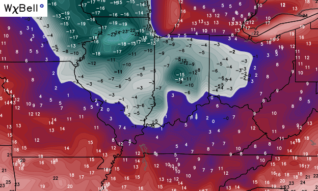
The Canadian Model was the ONLY model showing single digits for parts of our region this morning. It was showing that several days ago and never waffled. Here’s what it has for Wednesday morning…
Gusty winds could give us wind chills from 0 to -10. Ouch!
Temps recover quickly for a brief moment toward the end of the week as a storm develops ahead of another arctic outbreak. This storm isn’t being handled well by the models, but it’s possible we see another rain/mix to snow scenario as temps crash… Again.
The Canadian Model temperature forecast is unreal to see…

Updates will come your way later today, so check back. Stay warm and take care.

Not much to talk about as far as snow goes here in Knox Co. Interesting point is that historically this is the low week as far as winter temperature is concerned. Starting next week, temps start ticking upward as far as averages are concerned. With no snow up to this point I guess I will just look forward to average temps hitting the 50s here in southern KY in about 5 weeks.
No talk about much anywhere really, since cold and wind appear to be the main players for January- at least. Just as long as no ice, all good IMO 🙂
Maybe February will have bigger chances.
The averages I’m talking about above is high temps
i don’t understand why to put out “guessing” snow fall totals … all news outlets put out that my area was going to get half an inch snow yesterday and i never seen the first snowflake on the ground .. seems pointless, about as bad as making a bold winter prediction that it will be a lot of cold and snow, and here we are second week of Jan and seen nothing.
I would respond to this, but you make absolutely zero sense. Not one thing of what you just said applies to me.
Don’t fall for the bait, CB!
And the back yard lack of snow whinning begins..yeah Chris don’t even bother..most of us know you don’t spot cast everyone’s backyard..and to complain that it’s not cold!?!..huh?? I agree with Chris no sense…if your an avid reader you’ll know the winter forecast called for a back end loaded winter…and given the fact winter just officially began late December..I’d say the BACK END is February \march…but hey who am I? A meteorologist?.. No just blog reader from DAY 1 OF THE BLOG from way back in the day…and I did sleep at the holiday inn express last night..!!lol..lol…I couldn’t resist..hope everyone has a blessed day and be safe in the snow squalls tomorrow.. We all know how quick those can snarl up traffic especially in the hills..
Oh and it was 12* here in South East tn. With no snow cover..I call that pretty cold…
Winter just started, and it is cold, and we have snow. This blog has been on target, honest, and informative.
huh huh boy did i touch a nerve … i thought i was commenting on an adult weather blog, my bad i did not know it was candyland. don’t take the “bait” CB …what the heck does that mean ? did i mention any names … ummmm NO
As we finally say goodbye to fall and transition into true winter, we also say goodbye to David Bowie. R.I.P.
http://youtu.be/zbsWFq2y0XM
RIP, Bowie
Epic bummer 🙁
Nirvana’s rendition of The Man Who Sold the World created even greater interest in David Bowie’s music through time.
Bowie rocked!
16 in Carrie of knott co this morning. Stil setting on no measurable snow for the year
8 this morning at The Monticello airport, but their temps are always about 3 or 4 degrees cooler than most other points in Wayne County. Nothing to speak of in terms of snow over the weekend…looks like nothing to speak of for Tuesday either.
Gonna be a tough call for superintendents tomorrow morning!! Snow not hitting until 7am around Ashland. Will they send the kids to school or cancel school due to the forecast of 1-3 inches snow throughout the day?
Thoughts?
I was thinking the same thing. I’d say most will probably do a delay to start the morning and go from there.
Boyd Co will probably cancel for the next three weeks lol The rest will go because snow almost always seems to dissolve before it hits the Ashland/Huntington/Charleston area. On the off chance that the 64 corridor does see snow, they will wait until it’s in full blizzard mode to dismiss. I am in Kanawha Co in WV and they love to send them then wait until the snow is pouring and dismiss after lunch. (They have to wait until after lunch to consider it a full day)
Wayne/Huntington/Ashland areas usually miss out on high totals anyway so usually no school closings. If it does snow it is likely it will be melted by the end of the school day and salt trucks will have done their work already so it should be good to go.
Please bring your animals inside or provide them a warm shelter during these bitterly cold temps. Why people leave their animals out in this weather just amazes me. If you see any animals in this situation please take a moment to report it!! Thanks Chris for all you do!!
Hey, NWS Louisville is learning that my part of SW Jefferson County is mostly incapable of getting more snowfall than even the airport from these northern systems. I’m forecast in the less than 1″ category while the rest of them are looking at potential for more than 1″
Radar filling in nicely in southern IL and IN.
I see midday update
I hope!!
About that time of the year to see the hits on this blog to go off the charts.
I like CB’s forecast. But, the convective nature of these clipper systems have a bust/surprise factor included. Therefore, some will be disappointed, but that means some will be pleasantly surprised. I recall a clipper system that was only supposed to give a dusting to an inch and woke up to over 4″.
Clean off those snow boards or whatever measuring place you are using. Don’t mix what has already fallen with the new amounts and report that as your current snowfall total. Keep your measuring place away from rooftops. You cannot believe how many inflated snow totals there are from people taking measurements on their porches.
Thanks as always, Chris. I appreciate you going out on a limb with your forecasts. Seems to me you have the best record of getting the weather right.