Good evening, gang. Arctic cold continues to pour into the region tonight as some areas get ready to head toward single digit lows. As we track this cold shot, we have some more action on the way heading into the coming weekend.
A double barrel low pressure system works in here on Friday with rain for our region. Colder air them spills in behind this system as a low on the east coast takes over. That gives us a transition to some light snow and snow showers…
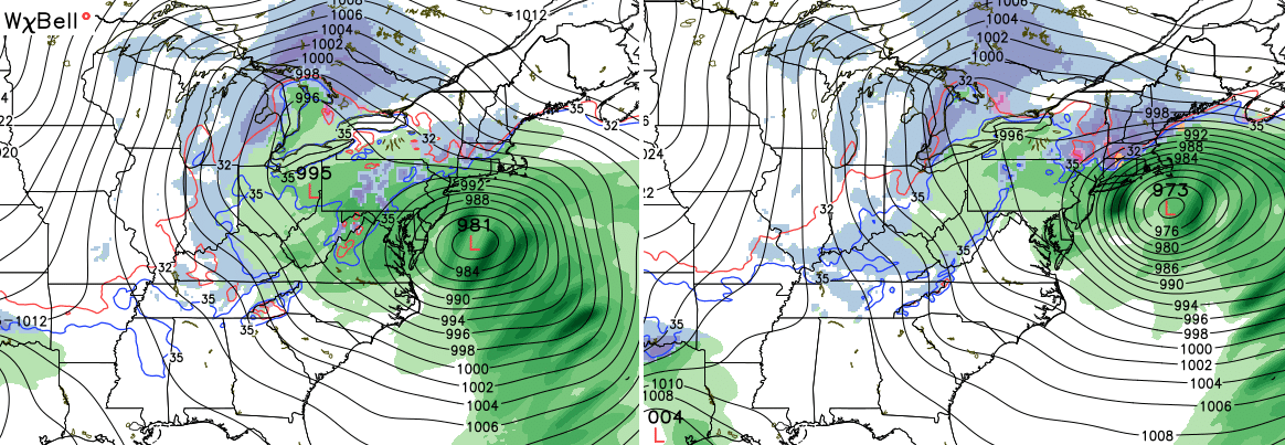
Most models then bring an arctic front in here on Sunday. The GFS continues to insist on allowing a southern low storm system to develop before that happens. It continues to brush our region with some snow Sunday and early Monday…
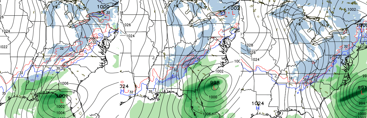
It then brings the true arctic front in here late Monday and Tuesday with another band of snow.
We certainly have no shortage of things to track. Enjoy the evening and take care.

Chris it’s no fun tracking these little snows if we can’t go outside and play in the snow with the kiddes I just soon see no snow little dusting are just no fun
While the southern states get a good snow possibly for the weekend. Go figure lol
Prelude you still have your bike?!?
Nothing to see here for the next week folks…our best bet is February for any real action. Im ready for this joke of a winter to be over
Thanks CB for the updates, and to whom it may concern I wasn’t trying to sound like a “brown noser”. I was just saying that CB doesn’t always get the forecast right, because nobody’s perfect. Sorry to anyone that it came across otherwise.
Hey Chris, we miss you here in Charleston, WV but I am so thankful to still have you nearby just off to our west on I-64! I trust your forecasts WAY more than NWS RLX (they really missed the boat quite a few times last winter), and I appreciate your insight and dedication! Please stay safe and thanks for the good hard work 🙂
Hopefully there will be something worth tracking soon.
Yes, I am hoping we get at least one good old school snow.
We are almost mid-January now and not even a promising week out miss up to now. I would just as soon have a little sunshine and 50 degrees than a 25 degree dusting. Probably set the record today for the least amount of snow to call a snow day for. That one will be hard to beat.
25 degrees and a dusting is conducive of a pattern ripe for a southern “old school” storm. We could get one of those in the next few weeks. Rodger in Dodger!
I’m just grateful for the warm weather that we had for so long and now we get the wintertime i’d much rather have snow than this frigid cold I hate going out every morning and starting my car before work I don’t have a nice warm garage to go in