Good evening, everyone. Another historic winter storm has wrapped up across the bluegrass state, leaving behind 1-2 feet of snow for many. The drifts out there are just insane! Judging by some of your comments and tweets, a select few who downplayed this storm are also downplaying the impact and snow totals. To that I say… LOL. 🙂
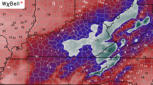
Now comes a bitterly cold night on top of this snowpack. Single digits are already showing up as of this writing. If the skies are clear where you live, you’re thermometer will hit zero or below. The GFS shows where it thinks that happens…
Yowza!
Highs will recover into the upper 20s and low 30s under partly sunny skies.
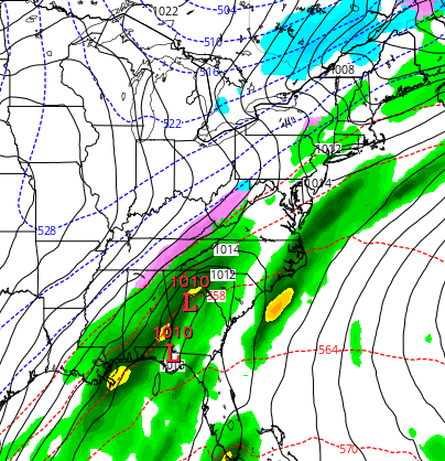
A cold front works our way by Monday night and Tuesday. This is not a very strong front, so it doesn’t have a big push of warm air advection ahead of it. The snowpack is going to impact temperatures, and now the models are catching up to that. Here’s the NAM for Monday afternoon…

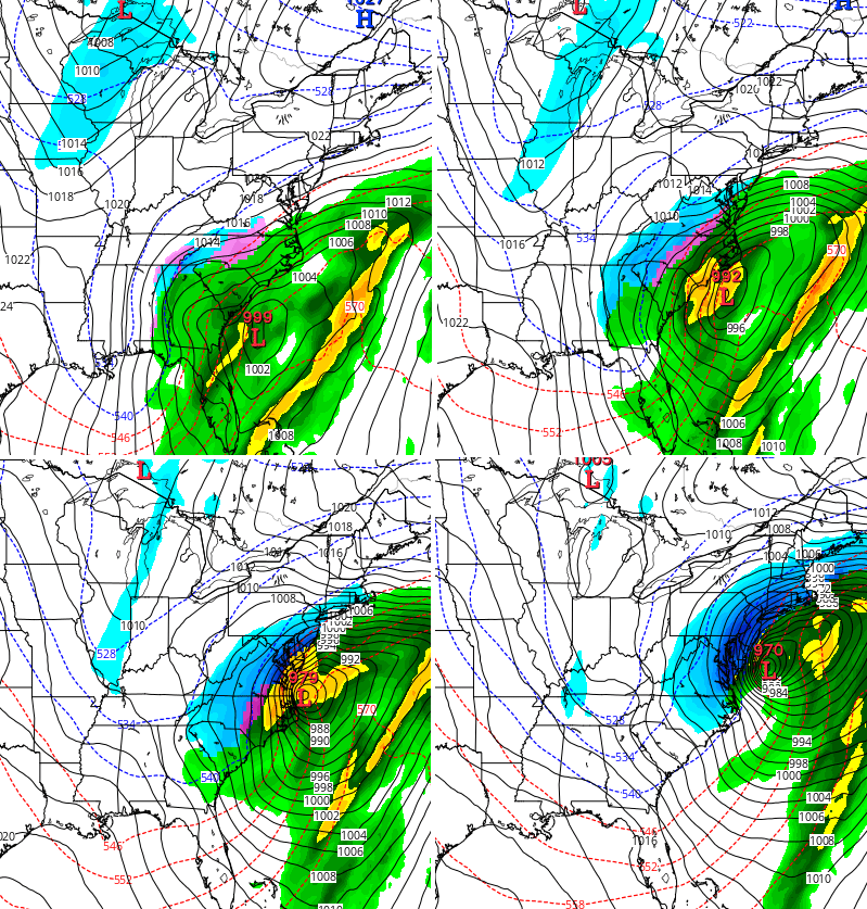
That cold front will have a band of rain and snow showers with it as it sweeps eastward into Tuesday. Colder air comes in behind the front, and some models try to pop a wave of low pressure along this front by Tuesday night…
That’s from the Canadian Model, which also pops a MUCH stronger east coast storm right behind that by Thursday…
The upper levels look favorable for another system to develop somewhere across the eastern part of the country. If it develops, does it impact our weather? That’s something to really watch for as we roll forward. Either way… temps for the middle and end of next week are seasonally cold.
I will have a full update tonight. Until then, stay warm and take care.

When you stick with the best, you dont worry about being played! That is why I stick with Chris Bailey
Ha! As usual CB’s forecast is more realistic than what the stupid weather channel is saying for next week. He really knows his stuff.
Hi Chris , I really love your forecasts but I think you made a boo boo on this one. You said the storm left behind 1′-2′ for everyone. Did you perhaps mean 1′-2′ ?
Not sure if that looks right. You said 1inch-2 inches when I am pretty sure you meant 1 foot-2 feet.
Well, if that storm tracks west a bit, we get it again. Interesting. Looking for at least 2 days of school this week in Laurel County…possible???
I got out today and even the main roads are dangerous. Kids aren’t likely to have school before Wednesday. Even if the temperatures are moderate on Monday, it won’t get rid of the stuff on the side roads. It’s deep. 363 between 1006 and 192 is dreadful, I’d hate to see it past 1006.
Please no more snow!! We had close to 18inches at my house in Somerset!! And drifts that are crazy high. I shoveled all day it seems like!! So my back is saying, please no more snow!
I feel ya….I just shoveled a walkway to the road and knew that the car would not see the light today…maybe tomorrow.
Now, now… the south central area of KY has been in snow drought since I have lived in my part of Richmond… Gotta give the snow lovers some fun!
I’ve had all the fun I want Mike. Lol!
Chris, you did an excellent job as always with this major winter storm. I’ve followed you and relied on you for your long range forecasting since I was in middle school and will continue to do so.
My wife and I are expecting our first child and she is certainly going to grow up learning that CB is the man! I truly hope she loves weather as much as her daddy does
I don’t even have the words to describe what an awesome meteorologist Chris Bailey is. We are so lucky to have him in this area!!! I live by this blog lol. Thanks Chris for all you do for all of us….even in the Huntington area you are my only weather source. A lot of us really depend on you!!! When someone tells me what the forecast is I always ask “what is CB saying?”
I live in Nicholas County, WV and still depend on CB for weather. So glad he includes our area in most of his weather maps.
Are you still thinking the worst of winter is coming in Feb? That was pretty bad and will probably hang around for a while!
Can you believe it has been one month when we were basking in unusually mild weather during Christmas week?
Snow coverage for the Midwest sector (where Kentucky somehow fits in) on December 23 was 0.1%. Today, over 78% has snow on the ground.
Yes I know they have KY in the midwest sector. I dunno why? Maybe cuz it’s so centrally located.
What did you end up with at your house Mark? Across the street in MS, we got 8.5″ “unofficially”
Appreciate the hard work CB put in during the past week. My job is very much impacted by the weather, so having an actual reliable weather source is valuable. The clown show at another station completely swung and missed yet again. Funny how they are now saying that snow totals must be high because people are measuring drifts and not accounting for the previous snow. As if 100% of the hundreds of people in the state reporting snowfall totals are complete morons and measuring only drifts, haha! Good try at spinning your failure.
So glad to have had the heads up a week a head of time concerning the storm. We had time to get our generator fixed and prepare for whatever. Thanks, Chris. You have a faithful following in this neck of the woods.
Thanks CB for everything you do!
Just came over to the blog, so bastardi tweet that canadian model out. Very interesting
*saw
Must admit I would like our old trend of model missed to start again 🙂 Really. Sorry though to the snow fans 🙂
Getting OLD Bubba?
This was bout as an epic snowstorm as they come. Only thing that stinks is that it came so early. Betcha feb and March are boring and cold. Makes it seem to go on forever. Bring on Spring. Thanks Mr Bailey for all you do. You’re the best.
They ain’t nothing I can say that has not already been said! But…. I would like to say for myself. Thank you Chris!!! I love it when I can say * I’m not surprised at all, that’s what my boy friend Bailey said all the time*
Makes me smile.
Here in my little part of Letcher Co. (Jenkins) we ended with 12″ that was Wednesday thru Thursday. That little warm slot hung on for quite a while so we had a long period of nothing, but finally filled in and started snowing again.
And we were ready for it!
Same here in Pikeville but then it started back just like Chris said and snowed all last night.Hope everyone stays warm.
CB, don’t believe the Richmond Mesonet reading, that thing is wack. Look at the difference across the area and even areas that have even more snow than we have. Remember the crazy -36 below event that instrument tried to perpetuate? It desperately needs recalibrating when it comes to cold events.
Also, I’m with Darth Bubba on the bust train. If it’s more than a coating, I don’t want it to happen going forward.
I think that thing is somewhere in Waco. But yeah, way outta whack.
Thank you, CB!!! You were the ONLY one who saw this coming and put the word out! I hate weather channel and NOAA, their weather forecasts NEVER are accurate!! They are a joke! Keep up the awesome job!! Also, thank you for the endless hours you dedicate to us!
Well TWC seems to think that another flip in the weather pattern is coming..back to the dreaded ridge in east trough out west..they were showing temps. Here in tn. By next Sunday 60-70 degrees…that would be my luck given I missed out on the historic snowstorm down here…