Good afternoon, all. Fog and a few flakes are dominating the weather out there today. Some better weather moves in over the next few days, but my focus is on a potent look trying to take shape next week.
Go back and look at my earlier post about where the pattern is going to get all my thoughts on it. I just wanted to drop by for a quick update to show how the GFS appears to be locking in on a big eastern US winter storm…


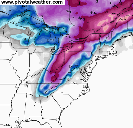
As I mentioned, don’t focus on a snapshot in time about where the storm goes or where it shows the snow. The only thing to watch for is the models are showing a hefty storm system across the eastern part of the country. It may or may not have a direct impact on our weather. I’m just showing you the strong signal.
I will have another update this evening. Take care.

Hopefully this storm comes to fruition and a little further NW. Seems Weatherbell and Joe Bastardi’s winter forecast is spot on with the percentage of snow above normal for the Southeastern part of the country. Just hoping the track of late can shift a little to the NW and give the Ohio River counties a nice smack down before winter retreats later in March. THINKS SNOW!
Think SE shift…lol
What days is this for?
February 23-25, roughly.
Thank you!
Thanks CB for all you do to keep us updated. Hoping for a NW trend to get SOKY in some good snow for next week! #ChrisBaileyRulesWeather
I know u don’t control the weather CB and I am not blaming u, however, I am over the snow this year where I am normally a snow lover. I need some sun in my life preferably with warmer temps but I could do cold temps if the sun would just shine down from a blue sky. I am sure I will get more excited about this next storm as it gets closer but for now I hope it misses Ashland….
That storm next week doesn’t look to promising for us in central ky as of now. I will hold my excitement.
Thelma Lou reminded me that those maps are kind of like the blue plate special at the diner…it looks good on paper but you never know how it’s gonna taste til it gets to the table.
I appreciate all the work and time that you put into these maps to show to us.Thank you and thank your family … we appreciate your love for the weather and your interest In sharing it with other people …
Get her to move a little west and that’d be dandy! Kids are still holding out for another snow day. And we’re hoping to put the sleds and boots to good use one more time. I do know that this cold drizzly fog is not my thing. Either spring or two feet of snow. Not to much to ask eh?
Thanks Mr Bailey
Amen! Move west storm!
LOL–If you are in Central KY or Western KY, you would want a NW shift next week, but us folks in SE KY will want little change or slight SE trend.
Location, Location, Location, and oh, temperatures!!!
Not to much the kids have missed to much here due to high water
at least this one has the banana high pumping colder air into it when it shows it going into a neg tilt. I just wish the air looked colder that the high is bringing in… and yeah, it needs to shift 50 to 100 miles to the west
Saw first hand today the difference in the last couple snows for our area. Where heavier bands would set up. We traveled US Rt 35 from Gallia Co. to Chillicothe. The difference in snow pack 4-5 miles east of Jackson compared to 4-5 miles west was tremendous. On to Chillicothe was even greater.
Yeah, this one, as of right now a week away, is a good track for Eastern/SE KY slam type of storm. Not enough cold air wrapping in would be the only threat at this time, except the NW shift of course. Time will tell, but I think even next week’s threat will not be the last:]