Good Wednesday, everyone. Our harsh winter weather pattern is about to take a break for the next several days. That break isn’t likely to last very long as another deep trough digs into the eastern part of the country. The same pattern that has been with us for most of January and February looks to continue into early March.
Before I get into a pretty in depth look at what’s driving this pattern, let’s talk about the near term forecast.
Highs today will generally range from 35-40 degrees with mostly cloudy skies and some light snow and flurries. This will mark the 10h straight day with, at least, some flakes flying across Kentucky.
Better weather blows in for Thursday and Friday… Literally. Wind gusts on Friday could hit 40 to 50mph at times. If those winds do materialize, some tree issues could arise courtesy of the soggy ground.
Highs Thursday hit the 50s in the west with upper 40s east. Most areas make a run at 60 from Friday into the weekend. There’s a shower chance in there for Friday and Saturday, with a much better rain chance for Sunday. That’s when the pattern reverts back to where it’s been of late.
If you want to get an idea as to what’s driving this winter pattern, look no further than the PNA (Pacific North American Pattern) and AO (Arctic Oscillation). These two seem to have trumped all other signals.
When the PNA is in a positive phase, you get a big ridge along the west coast and into western Canada. That allows for a downstream trough to develop in the jet stream across the eastern part of the country. When the PNA is in a negative mode, you get just the opposite.
This year, the PNA has had an event greater impact than normal…

When the PNA was negative in November and December, we had record warm temps across our region. When it went strongly positive, we had very cold and snowy weather in January and through February. That included another history making winter storm in January.
The forecast for the PNA over the next two weeks takes it back into the strongly positive phase…

Given our recent history, one can assume with high confidence winter isn’t over.
I found a similar trend with the Arctic Oscillation. When it’s in the positive phase, we experienced warm to record warm temps. When it went negative, we turned cold and snowy…
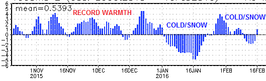
The forecast for the AO for the next few weeks is back into the negative phase…
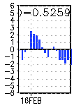
You can even see the brief spike over the next few days. Well, how is our weather looking through the weekend? Milder. It then drops off quickly next week and that’s when winter returns.
Now that we are toward the end of winter, I’m letting you in on some of the things I’ve been using to nail these patterns from a few weeks away. I’m also sharing this as a teaching tool for those of you who love weather as much as I do. I’m learning things about it every single day!
By the way, what happened to all the talk about this super El Nino being just like 1997-98? I spent all last summer and fall showing you just how different this Nino was and that it had no equal. I’m pretty sure everyone would agree with that at this point.
Now that we have an idea where the pattern is taking us. Are we seeing the models showing what should be happening? Yes, we are.
Cold air returns early next week as a deep trough dives into the eastern part of the country. This could very well spawn a big eastern US winter storm. The European Model is all over this…

The GFS is also showing a big storm system…
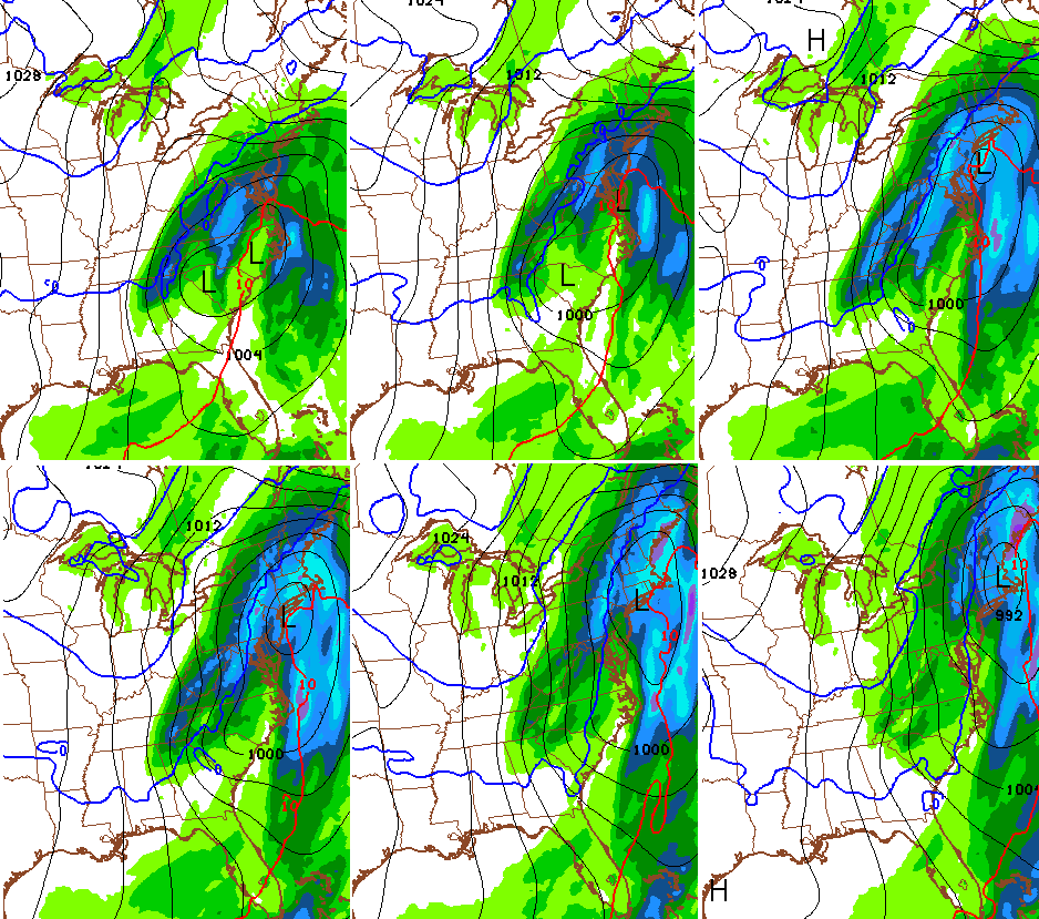
Don’t worry about where models are tracking a storm 5-7 days from now… the important thing is they are showing a storm.
The GFS Ensembles from Weather BELL consists of 21 members. Those members are pretty excited about next week…

None of this means there will actually be a big storm system next week, but it certainly would match the teleconnection pattern of the winter.
I will have updates later today so check back. Your snowflake trackers will take you through the day…

Have a great Wednesday and take care.

Phenomenal effort by Chris today…great teaching. Thanks a bunch.
Thanks Professor Bailey! LOL
I know you don’t usually have time to offer us this kind of teaching moment but I know we all appreciate it when you do.
I’ll be traveling first to Dallas on Tue and from there to D.C. on Thu before returning to Lex Friday night – I hope! ; )
I have been following your forecasts since you were at WSAZ. I live in Ashland and reading your blog is the first thing I read every day. Great lesson. Thanks.
Nice! Thanks for letting us in on your secret!
Don’t think you’ll have to worry about the other meteorologists using this information. They’re too busy copying the 10 day forecast from the weather channel app on their iPhone 🙂
That’s funny! And a lot of mets are biased against cold and snow too. Rodger’s tired of seeing that. Rodger in Dodger
But those other meteorologists are just here to inform us, not to scare us. 😉
Thank you for the information and lesson! As a science teacher , this really helps!
Awesome info, thanks Chris!
Great info Mr Bailey! Thanks for sharing how you work your magic. Looking forward to one more little taste of winter and then I think me and my crew will be ready for spring.
Thanks Chris you have taught us all a lot you make the weather so interesting. We appreciate you. I share your love of the weather I guess we all do here.
Thanks for all you do! When, and if, you ever retire from tv , you should be a university professor. You are already a great teacher!!
Fascinating info, Chris. Thanks so much for taking the time to explain this weather pattern. Neat!
Bowling Green sets another mark…at 9.2″ for the month of February (so far), entry into the Top Ten Snowiest of Each Month has been achieved, this following last February’s Top Ten appearance and making it two consecutive months now (January of this year). Going for the trifecta in March may not be that difficult with this kind of pattern…only need at least 5″ for yet another Top Ten distinction.
I asked my father-in-law in Bowling Green how much snow he measured at his house from the last storm. His reply was that he didn’t bother, that he was tired of snow and ready for spring 😛 . I feel his pain!
But as CB and other mets are saying, we will go back into winter mode after the upcoming brief warmup.
Yeah, we already have had 24.0″. Wow!
thanks chris! .. i can remember 30+ years ago my granny hid easter eggs the night before the big egg hunt .. the next day it snowed so much we couldnt find the eggs for 3 days .. and nobody seen it coming
The huge snow storm of 1993 was in March right? That would be AWESOME!
Thanks CB…you’re the man….that is the only man I listen to when it comes to weather If I weren’t a nurse I’ll want to come work with you. Thanks for today’s lesson.
Will a low to the north block the cold air and chreat us outta snow again, tune in next week