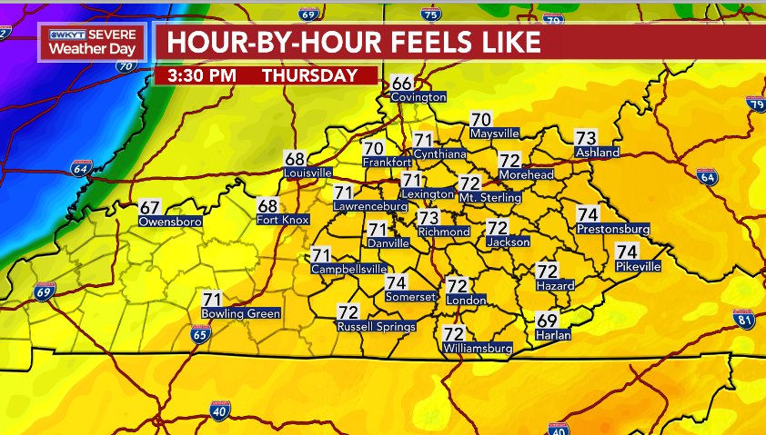
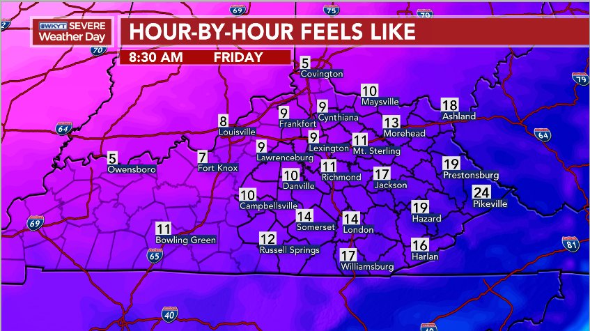
Good Thursday, everyone. Rounds of torrential rain producing showers and storms are rolling across the state today, bringing an increased threat for flooding. In addition to the flood potential, we are tracking the threat for strong storms and a gigantic temperature drop.
Let’s begin with the flood potential. Areas of southern and southeastern Kentucky are being drenched by repeat shower and thunderstorm action early today. That’s the prime spot for flooding and flash flooding to begin the day. As a cold front moves in later today into this evening, showers and storms will bring a renewed high water threat to several areas.
Here’s a look at the Flood Watch that continues today…

The current warnings…

That line of storms along and ahead of the front may spawn strong or severe storms as it moves quickly from west to east. Here’s the outlook from the Storm Prediction Center…

Temperatures this afternoon may spike into the 70-75 degree range into parts of central and eastern Kentucky…

Once the front crashes through here Thursday night, temps drop like the proverbial rock and reach the 20s by Friday morning. Gusty winds will make it feel MUCH colder…

Wow!
Another active setup is on the way from Sunday through the middle of next week. This pattern will have to be watched as it can also put down a lot of precipitation…
GFS
New GFS
I will update things later today, so check back. Here are your tracking tools to get you through until then…

Enjoy your Thursday and take care.


Harlan is getting hammered! I am crossing 2 inches at the moment with likely another 1 to 2 more to fall just by dawn. I say the Cumberland will at least reach minor to moderate flood stage by noon….just a good guess based upon how fast it is rising plus flash flood guidance!
You are beating me in rainfall again this year. I had 0.95 yesterday and currently at 0.94 so far today and 6.8 for the yr.
I bet we both top 20 inches for meteorological winter!
Looks like more of the same. Rain, rain, rain.
Ugh.
What happen to the snow chance? …
Looks like a repeat of 2018. Rain, rain, and more rain.
Haha, must be new to the blog haha
No I’m not new I’m very aware of the disappointment
I love rain. I’m so glad the next week and a half we have so many chances of heavy rain
Meh to winter!! This has definitely been the winter of what if’s. Fencetucky lives forever! Hope you people in the south have some waders. Your going to need them leading into next week.
Severe thunderstorm warnings, chirping frogs and blooming flowers in SE KY this morning.
Until the oscillations change, or I should say IF THEY DO, I see no change myself. Backloaded winter isn’t even light loaded yet. It does look like the oscillations are trending to change late month but close to March by then. Maybe we get one surprise March snowstorm and that is it??? All I know is I dont want the pattern to change in March and April and we end up having a bunch of cold rain/mix events with a nasty start to spring but still little snow to wrap up this horrible winter. This has been my least favorite winter and personal worse disappointment of all time as I and most expected a different outcome but the opposite has occured!
Looks like the MJO has been king this winter. We get another chance by middle to end of the month where all models agree the MJO will go back into 7 and then travel to 8 and 1 which are cold phases for us. No matter what other factors we have had in our corner this winter the MJO hasn’t been in the right cold phases during those times.
A pretty intense line of showers just came through, a lot of streams and creeks out of their banks here. Gonna bet we see some at least moderate rises on rivers in SEKY by this afternoon.
Right at 2.50 but still pouring! The worst barely went south last night with northern TN coming in over 4 inches around Claiborne county! My year-to-date is 7.60 so far and rapidly rising. Meteorological winter is almost 15 inches!!!
I about bet I hit over 20 inches again for another 3 month season. INCREDIBLE!
Flooding rain and 50 degree temp swings, two things you can take to the bank around here.
Once again I stand by my prediction winter is done. Rain train wins.
Mesonet near Somerset recorded a 58 mph gust this morning
I heard the thunder but not the wind. This afternoon is going to be interesting when the cold front blows through.
Yesterday Chris said “Winter is far from done!”
I totally AGREE!!!!
This Winter has been awful (not much cold and not much snow) with a lot of rain…..So yes, it is far from done!!!!!
I agree but really who knows ?
Only “Wild Ride” has been a bad “Water Ride” at some theme park this winter that won’t stop and let us off..lol
Polar Vortex (Actual Cold) 3 days. The “Bounce Back Warmup” 5 days and counting! 2 days in the mid thirties out of the next 5-10 days is hardly a “return to Winter”.
Luckily the heavy rain has missed me. However this is going to be the third Winter in a row to be missing in action. Single digit snowfall totals for the season. This would have been the fourth year in a row if not for one big freak storm in 2016 that resulted in 18 inches of snow. I can’t remember a more bleak stretch of Winter years in my life.
Is it me or does anyone else think that removing flood watches for the eastern part of the state laughable seeing what a coming.
Guessing 4″ isn’t enough already unless the rain is expected to weaken…a lot.
Predicting a “backloaded” winter for 2020….. stay tuned haha
I like that you are getting a jump on Bastardi and the gang for next Winter.