Good evening, folks. Heavy rain and storms continue to target the region, especially southern Kentucky. This is bringing an increased threat for flooding tonight then again late Thursday. This is all ahead of a potent cold front, bringing a major temperature drop.
I’m really going to watch the southern half of the state this evening as that’s the area getting in on the heaviest rain. The Flood Watch continues tor the entire state…

Strong to severe storms are possible across the western and south central parts of the state. This is the area being highlighted by the Storm Prediction Center…

The cold front sweeping in late Thursday into Thursday evening may also spit out a line of strong storms. The temperature trend from one side of this front to the other is absolutely amazing.
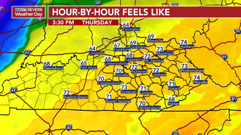
Check out the Euro Highs Thursday afternoon…
Now, check out where it has temps at by Friday morning…
Wow!
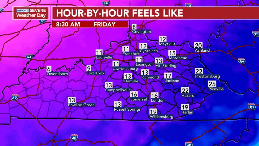
Here’s a little different model run showing the feels like change…


Double WOW!
Cold settles in for Friday and Saturday with single digit wind chills Saturday morning…
The setup after Saturday turns very busy once again as colder air tries to get involved with the systems moving our way. The new version of the GFS continues to lead the way in showing more of a winter look…
Winter is far from done!
I leave you with your evening tracking tools…


Make it a good one and take care.


I believe winter is done here in southern Kentucky. Every time its warm we get the most rain if its cold northern Kentucky gets the most snow so I’m not getting my hopes up for any type of winter systems for the rest of winter #TeamSpring
Has the new GFS been the most unreliable model this winter? Winter.is never over in February, but when the majority of your days are 50+ degrees it’s more of a spring like month than a winter month. The last two years southern Kentucky has averaged about 20 February days above 50 degrees. I think 2016 was the last cold February but a warm March followed. I’m sure we may get a few periods of below average highs, but that’s just typical for this month. Just wished it didn’t rain so much in Kentucky. Hopefully spring is near.
Still no indication of a good snow chance. Ankle biter seems the high bar and big snow not likely in any stretch. Winter without much snow is like beer without bubbles.
Still better than ice though 🙂
Is the new gfs all alone withe the winter looking threat???
Don’t even get me started on that God awful worthless model
Truth! I hope the old GFS stays. I have criticized the model over the years, but old GFS has done much better overall than any other model for several months now. Yes, we had a rare SE change for the axis of heavy rain today, so kudos to the Canadian this time, but old GFS has been best for a while on most storm systems in my opinion!
Thanks Chris. I appreciate you saying you are keeping an eye on my half of the state. We’ve had a lot of rain today. And from the looks of the radar it looks like we have a bunch more coming! Then we get free cold. Just wish we’d get a good snow to go with it! Have a good evening and stay dry everyone.
Awesome more rain. So glad winter is bringing more
Looks a lot like last February Cumberland River Flood event tonight!….humm
Pouring in Harlan and looks to be an all night event.
2.44 inches near Ray, Ohio. Looks like more on the way. Oh what fun!
humm, wasn’t this heavier rain supposed to be riding an axis SW to NE in KY? Instead, looks like the heaviest rainfall totals will ride the TN/KY state line from west to east. That’s ok, we here in southern and SE KY love flooding as we’re accustomed to it by now. Too bad we’ll never get a snowstorm taking this track.
Looks a lot like last February’s moderate flood event, doesn’t?
Funny, heavy rain actually will shift SE to include KY in a more rare model shift at the last day but would snow had done this?…about 99 chances to 1, snow would have shifted NW!….gurr
very true
Winter is right around the corner. The models say so!
The models been saying that since Thanksgiving. Especially those 2 week composite snowfall models.
The 2 words “far from” shouldn’t have been typed. How I read it is, Winter is done!
A dud rain event so far in the Louisville area. A whooping third of an inch event total. Pretty much every model for days had been forecasting 3-5 inches in the city. Tonight’s / tomorrow’s rain looks like maybe another 0.50-1.00 inch total. Not impressed.
There earlier were a couple of Tornado Warnings for D-i-c-k-s-o-n County TN and even western Davidson County (Nashville the county seat) based on radar indicated rotation. Not aware of any “debris balls” on radar nor any visual sightings of touchdowns. These warnings have long expired and so far no new Tornado Warnings have followed.
But numerous Flash Flood Warnings continue to pop up as the heavy rain is “training” over and over the same areas along I-40 in Tennessee. As Chris just tweeted, southern Kentucky may be next. Take care everybody!
I am wondering if Nashville is about to point of enudation as this is some extreme rainfall training over the city. I about bet a moderate to major flood event will occur before morning there! I hope no high water rescues but I foresee some with road closures a good bet!
Winter is just another week away according to the wonderful models. Is that a week from December, 2022? Meanwhile I’ll sit back and enjoy this God awful rain.
The only “whiteout” ive seen out my window is the dense fog and rain. Guess ill respool my fishing reel, but with all the rain it will take weeks if and when it stops for the water to go down.