Good Wednesday everyone and welcome to another waterlogged day across Kentucky. Another big storm is rolling into the Ohio Valley today marking the fourth such system in the past few weeks to bring heavy rains our way. This is setting the stage for some local high water issues today. The main flooding concern will be along our rivers that are already running very high.
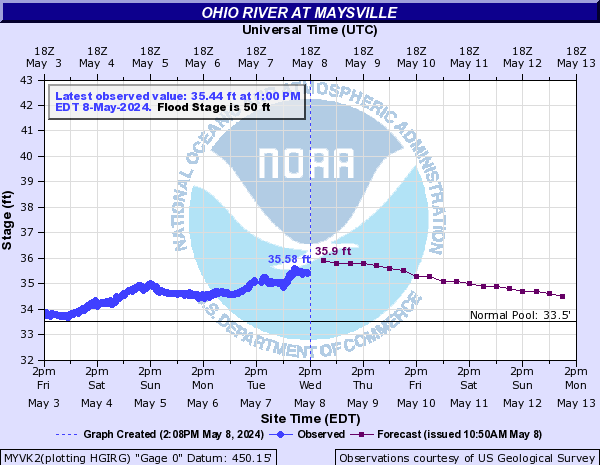
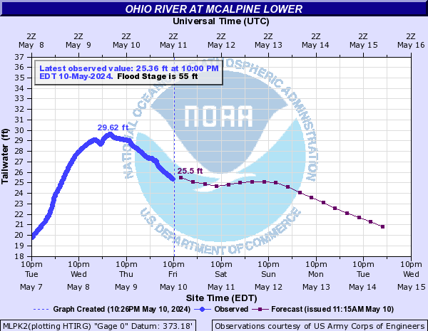
Some points along the Ohio River are now forecast to experience moderate flooding conditions over the next several days. More on that in a moment.
Low pressure is working across the northern Ohio Valley and into the Great Lakes today. This will drag a cold front across the region into this evening. A nice surge of heavy rain and some embedded thunder will be moving through during the first half of today before a bit of a break tries to set in this afternoon. This may allow for a broken line of showers and thunderstorms to develop along the actual front as it move eastward. A strong storm or two can’t be ruled out during this time.
In general… a 1″-2″ rain will fall across much of the area through Thursday with locally higher amounts possible across the southeast. This will be the area that has the best chance at seeing some stream flooding as this area will also see another band of rain moving in early Thursday as another low develops along the front.
Track the rains here…
This should not be a widespread flood situation by any means… but local high water issues will be possible as the ground is super soaked from recent rains.
Major rises are likely along the Ohio River over the next several days with many points potentially seeing moderate flooding. Here is a look at the forecast for the river at various points…


Much colder air will move in behind the cold front later Thursday and this may switch the rain over to a period of light snow. This should continue into Thursday night and early Friday across the east and the NAM is trying to spit out some light accumulations again…
This model did very well with the last system so we will see if it’s on to something with the current storm.
I will have updates as needed through the day so be sure to check back. Have a great day and take care.
Select Page

Rain, rain, go away, come again…sometime in August when we’ll all be beggin for it!!!
Yeah I thought these were supposed to be APRIL showers. I’m ready for some dry too!
While going through this post I felt that you have done a lot of research on the topic, I appreciate your efforts and glad that I found your blog. Keep posting such informative content.
we still got a snowstorm to get thru before its over, ole rolo bones can feel it.
ty BAILEY, I watch the others as they forcast and i think they read the blog word for word.
none of them though mention that secondary low with other saystem that hammered us with the rain late in evening.
hey mike and few others hope u got that SATURDAY LOCK on NEVER RETREAT in r10 at GULFSTREWAM.
GFS still trying to pump up some snow events… one being thursday night/friday morning for east ky…and its still trying to show snow for the 15th..and the big storm for the 19th/20th…(thats showing rain to snow)..and then another around the 24th…with the NAO going negative around that time could spell a suprise snowstorm for someone in our part of the world…to say that the THREAT of snowstorms is over is a bold statement to say the least…
I see the GFS still trying to pump up some snow events… one being thursday night/friday morning for east ky…and its still trying to show snow for the 15th..and the big storm for the 19th/20th…(thats showing rain to snow)..and then another around the 24th…with the NAO going negative around that time could spell a suprise snowstorm for someone in our part of the world…to say that the THREAT of snowstorms is over is a bold statement to say the least…
Didn’t Never Retreat run last Saturday at Gulf Stream? If so thats a quick turn-around.
WOW..nws, saying thunder snow/rain possible for thursday and thursday night for my area…and gfs, says a thumpin snow for thursday night and friday morn. for east ky..
Wow!!NWS. Is forecasting the possibility of THUNDER rain/snow Thursday and snow with thunder poss. On thurs. Night
And the gfs is saying a thumpin snow thurs. Night/friday morning for east ky. Storms around 20th/24th still popping up as well, and a possible snow event the 15th!
NAO forecasted to go neg. Around end of month could spell a snowstorm for our part of the world!!! To say the THREAT of not having anymore snowstorms this season could be a bold statement to say the least.
Even the NOAA website has snow for Thursday night…..how likely is it for EKY to get accumulation snow with this phase of the storm system? It seems to me it would melt when it hit the ground because of the warm temperatures we’ve had.
I will be very surprised if KY sees anything more than a dusting the rest of this season. The warm is winning and should continue to do so. I hope I’m wrong.
Paducah was already seeing Moderate flooding as of yesterday. Last night, another inch or two of rain fell on the Ohio River basin. Paducah is in trouble.
And what’s up with SPC giving areas north of I 64 no chance of thunder at all today? Seriously?
to quote an awesome song from Aerosmith ………… DREAM ON !!!!
I’d say light accums a good bet for parts of east ky Thursday night. If the next system comes through late Monday night could be another chance for light snow accums.
No major snow for us until next winter.
bring on the warmth 70s and up i’m so tired of mud!!!!
My knox co. Forecast from nws in jackson
Thursday…Cloudy. A chance of rain showers in the morning…then rain and snow showers likely with a slight chance of thunderstorms in the afternoon. No snow accumulation. Highs in the mid 40s. Temperatures falling into the upper 30s in the afternoon. West winds 10 to 15 mph. Chance of precipitation 60 percent.
Thursday Night…Cloudy. Rain and snow showers likely with a slight chance of thunderstorms in the evening…then a chance of snow showers. Colder. Light snow accumulations. Lows in the upper 20s. West winds 10 to 15 mph. Chance of precipitation 60 percent.
Friday…Cloudy with a slight chance of snow showers in the morning…then becoming partly cloudy. Highs in the mid 40s. West winds 10 to 15 mph. Chance of snow 20 percent.
Looks like winter has ended as abruptly as it started. We had a good run of it from the start of December until about Valentine’s day, but I would be VERY surprised if we get anything more, especially given how mild it has been for the last month…
Eastern KY got a nice slushy accumulation last weekend which was in March.
Wave 3 is saying low 70’s by the 17th
So is accuweather.
And they also have the 19th and 20th with lows at 24/25 and forecasted ice and snow.
😀
They also have the 10th and the 23rd with snow. heh.
umm wet snow Monday and/or Tuesday mornings. this system bears watching. could be a wet snowstorm JKL office mentioned this in there discussion.
I have an update over on my blog for those interested.
Looks like some decent bands of wrap around snow according to the canadian model for eastern ky late thrusday and friday..Could be a nice little event…we also had about 3 inches of wet snow the last storm in my neck of the woods..Stuck to the trees like glue..
Hi, The topic that you have discussed in the post is really amazing, I think now I have a strong hold over the topic after going through the post. I will surely come back for more information.
While going through this post I felt that you have done a lot of research on the topic, I appreciate your efforts and glad that I found your blog. Keep posting such informative content.
Hi, Thanks for sharing such a wonderful piece of information. I must say that while reading your post I found my thoughts in agreement with the topic that you have discussed, which happens very rare.
First of all, I would like to appreciate the effort that you have put in making such an informative blog. I enjoyed this post of yours and I must say that every time I come back to your blog, I always have something new and informative to read. Thanks for keeping me updated.
[url= viagra online[/url] Hallucinogenic hardened to through fragility
Lol typical Kentucy weather huh? 🙂
Hello, comrade! I’m totally acclaim this way of thinking and everything connected.
Good post! thank you
В ЖЖ за такой пост какашками закидают.
Informative, but not convincing. Something is missing, but what I do not understand. But, frankly: – Bright and benevolent thoughts.
As expected, has written atypically otzheg!
Hi!
Do you not think about the environment? Let’s work on renewable energy?
What can you offer in terms of advertising?
Theme your pretty complicated for a beginner.
Nicely presented information in this post, I prefer to read this kind of stuff. The quality of content is fine and the conclusion is good. Thanks for the post. soin.
All perfectly done
Informative and persuasive.
ok
Cool site
Hi!
Do you not think about the environment? Let’s work on renewable energy?
What can you offer in terms of advertising?