Good Friday, folks. We have a cold front dropping into the region to start the weekend. That’s bringing a swath of showers across the region to kick off the weekend. After a decent middle part, the weekend then looks to end with a few more showers on the move. Yippee… Said no one ever!
Temps today are all over the place with the north staying in the 50s and the south tickling the 70 degree mark. As our front drops in from the northwest, a wide swath of showers slowly covers the state through the evening…

This same system is also bringing a snowstorm to the northern Ohio Valley. Y’all can keep that!
Saturday may start gray, but ends up being a pretty decent weather day. Temps hit the 50s for many, with a 60 in the west.
Our next rain maker moves through Sunday into early Monday as low pressure passes to our south. That’s a big severe weather maker in the deep south, but should only manage to bring a few showers into Kentucky…
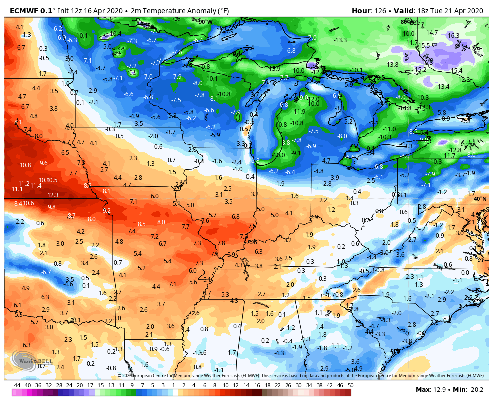
 Temps recover quickly behind this and I can see a few days making a run at 70 next week. The problem comes by the middle and end of the week with another storm system rolling through here…
 Depending on the track of that system, a few strong storms could show up in our neck of the woods.
The temperature trend next week is far from perfect, but you can see the seasonal struggle going on…
 If you’re thinking about summer, check back this weekend as I will show you a couple of seasonal summer models.
Have a great Friday and take care.

Thanks Chris, Yesterday’s weather here in central Kentucky was nice, but being a horticultural consultant it pains me to see all the freeze damage.
Thanks, Chris. I am always thinking about summer so I will be back.
Hopefully the folks in the Deep South avoid more bad storms this weekend after the Easter Tornado Outbreak.
I just looked up the three day severe weather outlook and it doesn’t look good for all those poor folks in the deep south. This is turning out to be the worse year ever. https://weatherstreet.com/severe-weather-forecast.htm
I’m thinking a possible 2007 summer repeat.
Jeff, I just looked up the “weather in review 2007” for Kentucky and it looks like we are on that track. (Here’s the web site in detail) https://www.weather.gov/media/lmk/climate/2007_review.pdf
I mention it because of the parallels with hard freezes in both months. Not everything works as we think it will, of course. 😉
3.7 inches of snow fell at the NWS forecast office in Romeoville this morning, and 3.0 inches fell at O’Hare Airport.
It certainly looks like early February instead of mid-April this afternoon here, with the snow from this morning still on the ground, even though some of it has melted. It’s a very chilly 35 degrees with a NE breeze under cloudy skies.
I think everyone would start feeling a lot better if we could see a lot more sunshine and warmer weather instead of doing a rain dance to make it rain let’s do a Sun dance…goodness only knows we need a ray of sunshine take care everybody