Good afternoon, everyone. We continue to deal with tropical rain producing showers and thunderstorms that are slowly moving around an upper low on top of us. This can lead to local high water issues for some through Sunday. At the same time, the Gulf Of Mexico is about to go crazy with two systems.
Let’s begin things with your radars back here in the bluegrass state…

Local high water issues will continue through Sunday and maybe even into Monday. From there, it’s all about the historic setup in the tropics.
Tropical Storm Marco is actually feeling the influence of the big upper low near our region. You can clearly see how the storm is responding to the southwest flow ahead of the upper low…

That is taking Marco a bit farther north, meaning less interaction with land. Marco should become a hurricane tonight or Sunday as it continues to work into the Gulf of Mexico. The track from the National Hurricane Center continues to adjust to the north movement, but still has a hard left turn before coming ashore early next week…

There is a growing spread among the hurricane models on where Marco goes. The Hurricane Models are still clustered on Texas and Louisiana, but a few are east…

Tropical Storm Laura isn’t as fortunate as Marco in terms of avoiding land. After struggling for a while, this storm may really explode once into the Gulf of Mexico. Here’s the current forecast from the National Hurricane Center…

There continues to be a decent spread among the Hurricane Models, but there’s a tight cluster aimed at Louisiana…

Can these systems have a direct impact the weather here in Kentucky? Yes! I think Laura has a better chance to do that than Marco. The operational models will dance a round a lot from run to run, but so are the direct forecasts for each system.
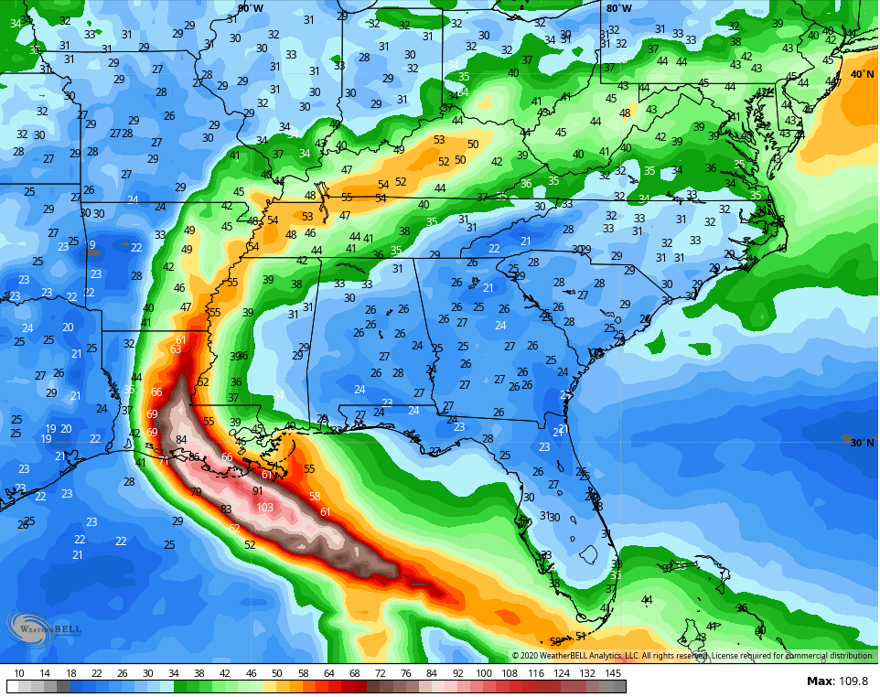
The current GFS takes Marco into Louisiana then follows with Laura. The inland track brings Laura all the way into Kentucky…
 You can see the path on the wind gust forecast from the GFS…
 The pattern following Laura may throw some deep troughs into the country into early September. At the same time, additional tropical systems are likely to impact the country.
If you’re looking for a polar opposite pattern from last September, this is probably going to be it.
Enjoy the rest of the day and take care.

Thanks Chris for the update.
You’re the go to guy for weather coverage across this state.
Great information Chris. I hope these tropical storms do not become hurricanes as I have Family in Texas, Louisiana, Mississippi and Florida.
So far we haven’t received any rain showers today. Good !