Good afternoon, everyone. I wanted to drop by for a quick update on Laura as it slowly rolls toward the Bluegrass State, arriving Friday as a Tropical Depression. This will bring some nasty weather our way, with severe storms, heavy rainfall and high winds a good bet.
Laura will weaken into a tropical storm this afternoon as it works into Arkansas. From there, the official forecast from the National Hurricane Center continues to bring this across Kentucky as a Tropical Depression…

If we compare that to the forecast I made from this past Sunday, it’s VERY close…
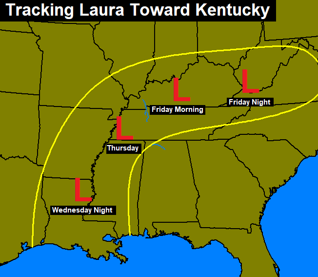
I was a bit east of the current track and a little fast, but the Kentucky track looks to be in terrific shape. I’ll take it from 5 days out!
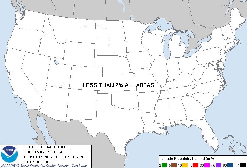
As this rolls across the state, strong to severe storms will be possible. The Storm Prediction Center has a Marginal to Slight Risk out for most of the state for Friday…

The threat for a few tornadoes will be noted along and ahead of the center of circulation. The SPC is giving the highest risk for tornadoes across the western and central parts of the state…
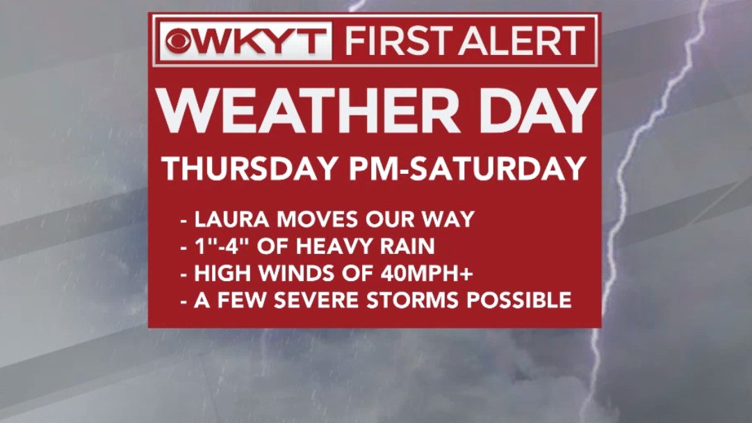
Damaging winds will also be possible and those may occur with our without thunderstorms. Gusts of 40mph+ will be possible with our depression.
Flash flooding will also be possible as the system rolls eastward. Rainfall totals of 1″-4″ will be possible for many locations. Here’s a quick look at the setup…
Behind all this, we really have to watch for a very active setup with storms and heavy rain early next week. This ain’t your 2019 September pattern taking shape, folks!
I will have another update this evening and be on WKYT-TV starting at 4pm. I leave you with your storm tracking radars…

Make it a great day and take care.

Thanks Chris for all your hard work and keeping us updated on Hurricane Laura.
Now we will have to watch how she will treat Kentucky ?
Thanks Chris for all your hard work and keeping us updated on Hurricane Laura.
Now we will have to watch how the tropical depression/remnants will effect our area.
The damage I’ve seen on TV and internet videos along the Gulf was unreal.
I’m afraid that more of these tropical storms/hurricanes will form in the Atlantic over the next three months.
Something that this country does not need in this horrible year 2020.
Today is the fifth day in a row of temperatures over 90 degrees in the Chicago Metro area. Tomorrow will make it six days in a row, but there is already an enhanced risk of severe thunderstorms for late tomorrow and tomorrow night for much of Northern IL, just west of the Chicago area, as a strong cold front moves through. Hopefully there won’t be any derecho like what came through here 2 1/2 weeks ago.
That would be really rare Mike if another Derecho occurred in your area in the same year.
All I can say about that is “hope for the Best.”
Mike, I hope those thunderstorms aren’t severe and that cold front brings you more “Fall Like” temperatures over the next few days.
I hope we get at lease a few days of “Fall Like” weather here too, but with the tropics the way they are I doubt if that is going to happen.
Really hard to say what the remnants of Hurricane Laura will bring to our area of Kentucky. The way this year has been going so far nothing would surprise me. #begone2020
Wow, that miserable Mike, but it is here to with these high dew points and heavy rain on the way for tomorrow night and early Saturday.
Thanks Chris for your updates. I will report my rainfall totals Sunday. Hope no one gets flooded or has any of those “spin up tornadoes.”
Very sad looking at all the damage along the Gulf coast. We have nothing to complain about here in Kentucky compared to other areas of the country.
Good news is that meteorological Fall starts Tuesday.
Mike, I hope those thunderstorms aren’t severe and that cold front brings you more “Fall Like” temperatures over the next few days.
I hope we get at lease a few days of “Fall Like” weather here too, but with the tropics the way they are I doubt if that is going to happen.