Good afternoon, everyone. Tropical Depression Laura is rolling across the state and is bringing the potential for damaging winds, a few tornadoes and local flash flooding. I’m just dropping by to set you guys up to track everything as the system moves through here.
There is a Tornado Watch for areas of west-central Kentucky until 8pm EDT. Here’s a look at that particular watch…
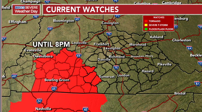
That may get pushed a little farther east in time. BTW, the above map will not update to show any new watches.
In addition to the severe threat, areas of 1″-3″ of rain will show up. Pockets of flash flooding are very possible into the wee hours of Saturday morning.
Our interactive radar has you covered with all your storm tracking needs, so give it a spin…

As a cold front works in late Saturday, a few strong storms will be possible across the southern half of the state. That front slows down with more storms developing along it later Sunday into early next week. Yet another front then moves our way later next week with more storms and a blast of cool behind it. This looks to be the opening act to a major shot of fall chill that may show up here in the next one to two weeks. I will get into all that later tonight and through the upcoming weekend, so check back.
As far as today’s severe threat, I’ve got the latest on WKYT-TV all evening long. I leave you with the rest of your Friday storm tracking toys…

Current watches

Possible Watch Areas

Enjoy the rest of the day and take care.

Lots of low hanging clouds, and on the radar a broad band of heavy rain is about to enter Taylor county.
At this time no rotation has been detected.
The tropical depression has shifted south along the Kentucky/ Tennessee boarder and moving east.
Not much rain this time unless it comes later. The energy is more to our south.
Good that things are calming down; the most recent Storm Prediction Center update has lowered the severe threat for us. The lightning map is indicating almost no more lightning strikes in Tennessee and especially Kentucky this evening. There were some Tornado Warnings near Nashville TN earlier, but the closest tornado touchdown I’ve seen so far is an EF2 in eastern Arkansas. Speaking of dodging a bullet, the western side of Laura’s eyewall (generally the side with the strongest hurricane winds in northern hemisphere tropical cyclones) came ashore mainly through unpopulated marshland/nature reserves just west of Lake Charles/Cameron LA and just east of the Texas line. The wind and storm surge damage was bad enough, but could have been even worse if Laura had made more of a direct hit. Fortunate roll of the dice.
Have a great weekend, everybody.
Also, the threat of severe weather that was in the outlook for the Chicago area for Friday night never came to be, as the storms really fizzled out well before getting here. Only a few places got any rain at all in the Metro Area. Our short-term drought continues, with very little if any measurable rainfall for the last 2 1/2 weeks here, and no significant rainfall in the forecast for the next several days.
We escaped the rough weather last evening, receiving some brief heavy rain.