Good Monday, everyone. First off, this is a blowout post so buckle up buttercup!! Some areas are kicking off the week with frost as temps start out deep into the 30s. We could do this all over again early Tuesday before temps turn absolutely pleasant for the rest of the week. Once into the weekend, a developing hurricane may have a direct impact on our weather.
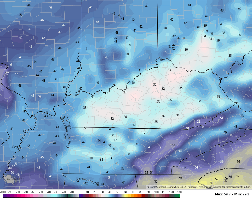
Let’s get your Monday started with the precious present and roll forward. Frost. It’s likely to start the day across areas of western and central Kentucky and will be the third round of some frost in the past week. Temps for highs today will range from the upper 50s to low 60s for many. This is still well below normal.
Lows by Tuesday morning are likely to drop back into the 30s, this time farther east…
Radiational cooling will make for some sneaky lows, especially in the valleys.
The rest of Tuesday looks good with highs ranging from 65-70 which is still below normal. Highs do reach the 70s for Wednesday ahead of another push of below normal air swiping us from the north and northeast.
The headline maker of the week is coming from the tropics and this is an area I’ve been highlighting for a few weeks now. Delta is developing and is forecast to become a hurricane into the Gulf of Mexico this week. Here’s the latest from the National Hurricane Center…

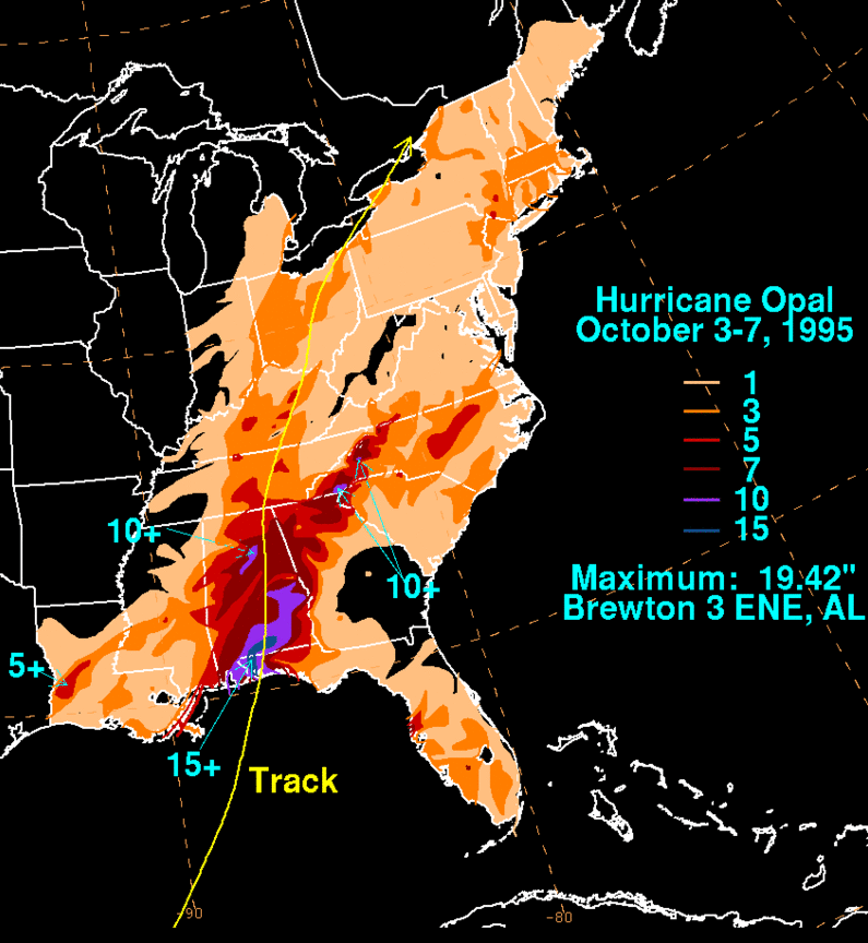
About a week ago, I pointed toward 1995 and 2010 as being some of my primary analogs for the rest of fall into winter. I pointed out how each of those years featured systems developing in early October down in the Caribbean. One of those storms was Hurricane Opal from 1995. This storm brought a lot of rain to Kentucky as it tracked right on top of us…
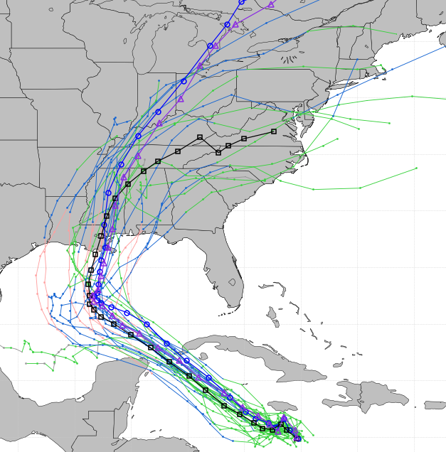
Of course, no two storms are ever the same or take the exact same path. But, it’s interesting to note the similarities to what’s going on right now with Delta. Check out the forecast from the GFS Ensembles…
The forecast from the Hurricane Models are similar…
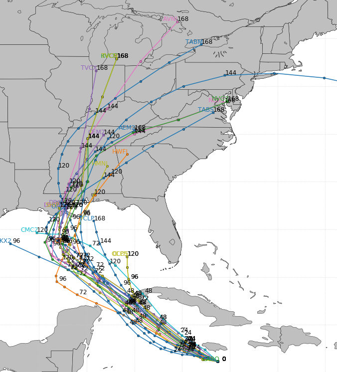
The exact track of this storm isn’t even close to being set in stone, but we seem to be following the 1995 analog pretty well at the moment.
Speaking of 1995 as an analog. I ran some numbers today because it hit me just how short our window was this year between temps in the 30s. If we take Lexington as the focal point, out last spring temp in the 30s was May 12. Our first fall temp in the 30s was October 2nd. That’s 143 days in in between which is the shortest window we’ve had since… 1995. That year was also at 143 days (May 3rd-September 23rd). 1995 started with an El Nino and transitioned into a fall/winter La Nina and that’s exactly what’s happening right now.
If you’re wondering, 1983 holds the top spot in the nearly 50 years I’ve looked at so far with 118 days between temps in the 30s. BTW… That was also a year transitioning from El Nino to La Nina. Interesting, huh?
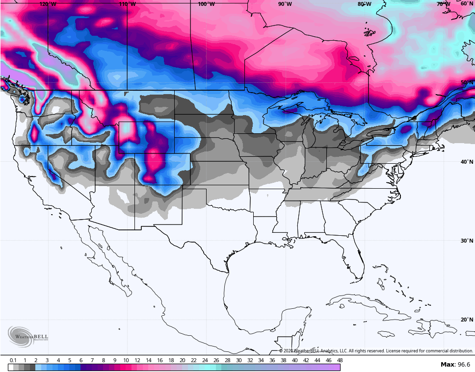
The new run of the GFS weeklies goes through November 7th and continues to show the potential for late October or early November flake action around here. Here’s the quantitative snow map from now through the first week of November…
Again, this essentially a brand new model so I really don’t have a feel for how good it is. Still, we will give it a whirl to find out. 🙂
Speaking of the GFS, the operational run of the GFS is now showing the first flakes out there in la la land…

So that is for October 16-18, but don’t get too attached just yet. 😉 But, this is even early for the GFS to be showing fantasy flakes!
Your friendly weatherdude is enjoying a few more days off from my TV job, but KWC takes no days off. I’ll see you later today for any update. Make it a good one and take care.

It’s a cold, frosty early morning here in the Chicago Metro Area, as we’re experiencing our first widespread frost of the season outside the Chicago urban heat island. It’s 33 degrees as of 5 AM local time in the SW suburbs near the NWS forecast office in Romeoville.
Looking forward to a great week of weather for outdoor activities here, with sunny skies, no rain, and temps ranging from the mid 60s to low 70s. The Chicago area received around 3/4 of an inch of rain total this past week from three different rain systems.
Just checked. Fayette Mesonet 42.2F. KLEX is 35F.
leaves coming along very well, best in quite some time. so of course 2020 brings the remnants of a hurricane over us near peak foliage
I hate trying to dress for the weather in the Fall. – Temperatures in my part of the state (North) overachieved this past weekend. I was prepared for highs to barely hit 60 degrees so I was unprepared for what actually happened.
– I’ve been hoping this coming weekend will have spectacular weather, but this Delta system is looking to spoil that idea.
– Opal was still a Tropical Depression when it crossed into Kentucky and the wind walking around the UK campus in Lexington was notable, although not damaging by any stretch.