Good afternoon, everyone. We had the coldest start to to the young fall season this morning and the numbers may be similar by Tuesday morning. This means frosty cold temps and even a light freeze will be possible. As we look down the road, we are watching Delta potentially bringing rain our way by the upcoming weekend.
If you’ve been reading for the past several days, I’ve been talking about how most sources, notably the NWS, were missing the cold mornings and the areas of frost we’ve already had. I hoped they would do better with this current cold shot, but that just isn’t the case.
Let’s set the stage with where we started today…
It was easily the coldest morning of the young fall season with some spots hitting the upper 20s. Here are the top 10 coldest temps from the Kentucky Mesonet. #kywx pic.twitter.com/g84fkIdTNI
— Chris Bailey (@Kentuckyweather) October 5, 2020
Lexington hit 34 degrees today and that was only 1 degree away from the record low of 33 in 1935. It’s our already our third morning in the 30s this month. #kywx
— Chris Bailey (@Kentuckyweather) October 5, 2020
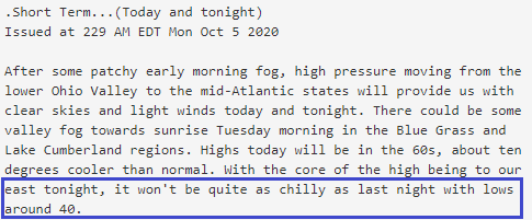
Here’s the NWS forecast discussion from Sunday afternoon talking about how only southern Indiana would see the 30s…

The updated discussion later in the evening…’

So again, temps this morning reached the low and middle 30s for much of their forecast area and even dropped below freezing in some areas. All without any kind of Advisory or Warning.
The stage is set tonight for similar temps to show up, especially in the colder valleys of central Kentucky. The NAM is absolutely crushing the poor GFS and EURO with lows and here’s what it’s showing tonight…

I suspect the 40s in the east is because of some fog forming.
Here’s the latest forecast discussion for tonight.
I cannot remember temps ever being at the levels we’ve had this early in the season and not having a single Frost Advisory.
The forecast for the middle and end of the week continues to look very pleasant. Temps warm into the 65-70 degree range by Tuesday afternoon and into the 70s Wednesday. Those numbers come back down some by Thursday and Friday as all eyes will be on the Gulf Coast by that point.
Tropical Storm Delta will become a hurricane and I think this can become a Major Hurricane before coming ashore. Here’s the current info and forecast track from the National Hurricane Center…

I’ve repeatedly pointed out the pattern being similar to that of 1995 when Opal made it all the way into our region. Now, that’s not saying this will become another Opal or take the exact same track, but the setup is similar. The GFS brings this system right on top of us this weekend…

The GFS Ensembles agree with this overall thought process…

The EURO has struggled with tropical systems all year, but then again the model has struggled with everything all year. Still, it brings what’s left of it our way this weekend…

Nothing about the track of this system is set in stone and it could very well just graze us with a track to our south. That’s something the Hurricane Models are now suggesting…

We must keep a very close eye on this in the coming days because, if it tracks over us, some big time rains will be possible.
Enjoy the rest of your day and take care.

In 2019 UK played a lot of their home games in the rain, maybe 2020 will be a repeat.
Rain is UKs friend.
And UK could use a friend right now. Bring on that rain! 🙂