Good Tuesday, everyone. It’s another day starting things out with frosty temps in the 30s for many areas. This marks the 4th time in 6 days where temps have been this cold or colder across the Commonwealth. Nice weather looks to continue through the week, but the weekend is a different story. That’s when what’s left of Hurricane Delta is likely to have a big impact on our weather.
Let’s kick this party off with what’s happening out there today. Highs are generally in the 65-70 range for many with a partly to mostly sunny sky. Those numbers increase into the 70s on Wednesday as a weak front slides in from the north and northeast. That won’t have any rain with it, but it will knock the numbers back down several degrees.
This is where things may get interesting around here. Delta is now a hurricane as it moves closer to the Gulf of Mexico. This should grow into a major hurricane over the next few days as it heads toward a late week landfall along the central Gulf Coast. Here’s the latest information and track from the National Hurricane Center…

As of now, there is a better than even chance we see a direct impact from Delta. The remnants of this may move into Kentucky this weekend, bringing heavy rain and gusty winds. Here’s my very early look at where the remnant low may track…
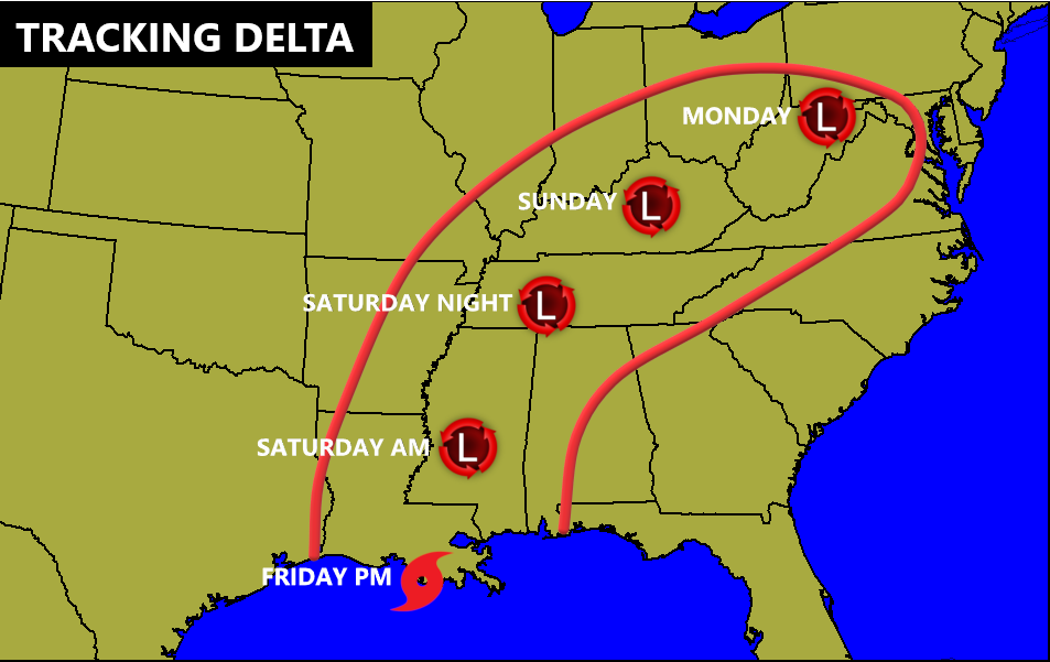
Obviously, the exact timing and track will be updated as we get closer. Right now, rain may arrive as early as Friday night and continue through Sunday night.
The GFS and Canadian Models are on board with this line of thinking…
GFS

CANADIAN

The latest hurricane model forecasts have trended farther west and more in line with recent runs of the operational models and Ensembles. This shows more of a Kentucky impact than before…

I will have additional updates later today, so check back. Have a good one and take care.
