Good afternoon, folks. It’s a rather seasonable day across the Commonwealth as we continue to track our developing winter storm system still on track to impact our weather from Sunday night through Tuesday. This will bring the first accumulating snow of the season our way and it comes in two opportunities… From a surface low, then from an upper level low.
Ok, let’s freshen up the breakdown:
- Rain arrives from the southwest Sunday evening and continues into Sunday night. As our surface low strengthens as it tracks from east Tennessee into West Virginia, it pulls in much colder air behind it. That means western Kentucky into parts of central Kentucky see a switch to snow by Monday morning. (That switch won’t hit the east until late day)
- A swath of accumulating snow will be possible in the above mentioned areas. That will be intensity and rate driven as it fights a wet ground and temps just a little above freezing.
- This part of the system has not been something I’ve been keying too much on because of the limiting factors I just mentioned. That said, the signal for sticking snow out of this is a little stronger.
- If you’ve been reading, you know I’ve been talking mainly about our snowfall coming from the upper level low and northwest flow coming in Monday afternoon through Tuesday. This is a stout looking setup with plenty of moisture available. Lake Michigan will be a big contributor as well.
- The prime time for accumulating snow continues to be late Monday afternoon into the first half of Tuesday. If we get snow to stick before this, I will consider that a big, beautiful bonus, especially in the western half of the state. That’s their best chance out of this whole thing. Central and eastern Kentucky have the greatest risk later in the day through Tuesday.
- I don’t have a First Call For Snowfall map put together yet, but I should get that out later today. Initial thoughts is a coating-2″ would be the floor for this event, with 3″-6″ for some as the ceiling. This is more than likely an advisory type event. For the first flakes of the season, I assure you we could do much worse. 🙂
Let’s take inventory of the various models to see how they are taking shape.
The one thing that stands out like a sore thumb is the… GFS. The model continues to have convective feedback issues causing the model to be much weaker and farthest east with our surface low. Look at the track on the low…
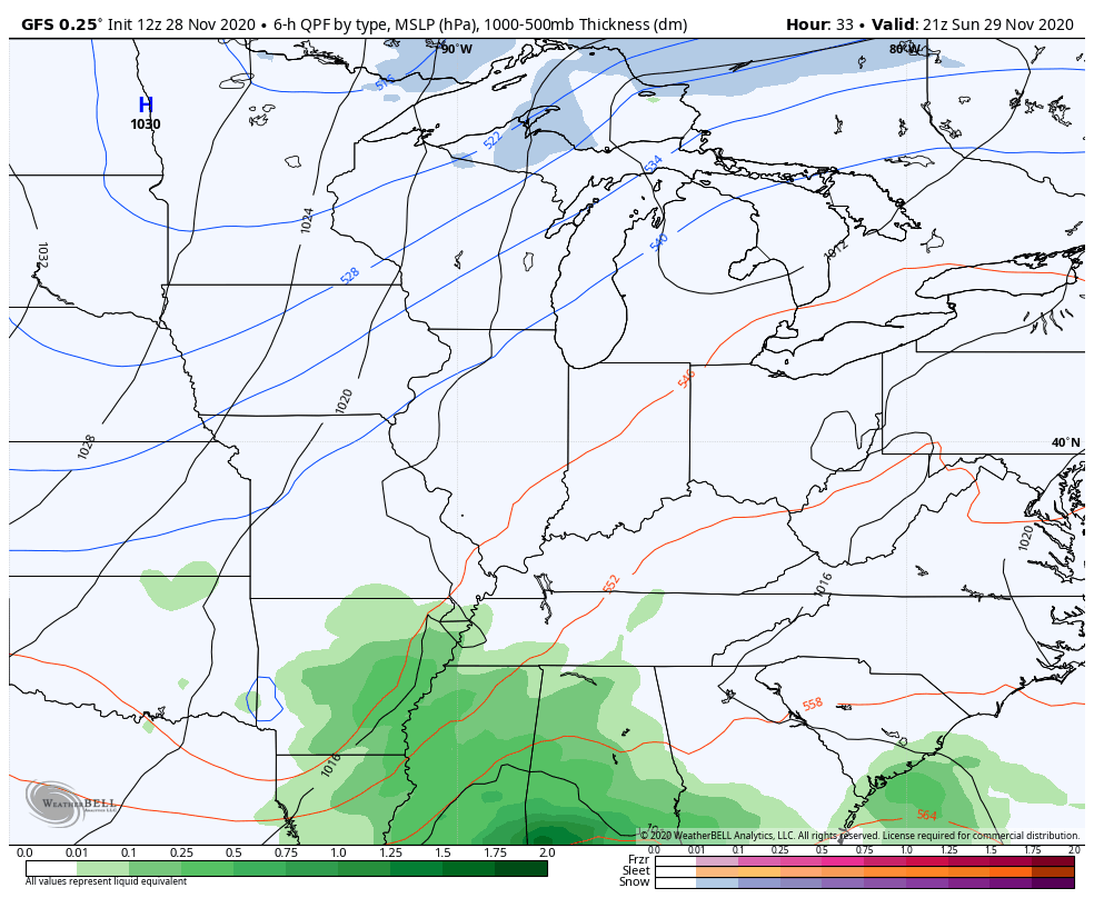
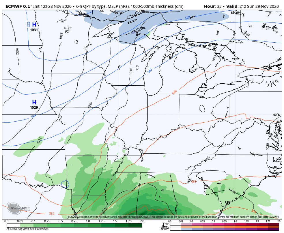
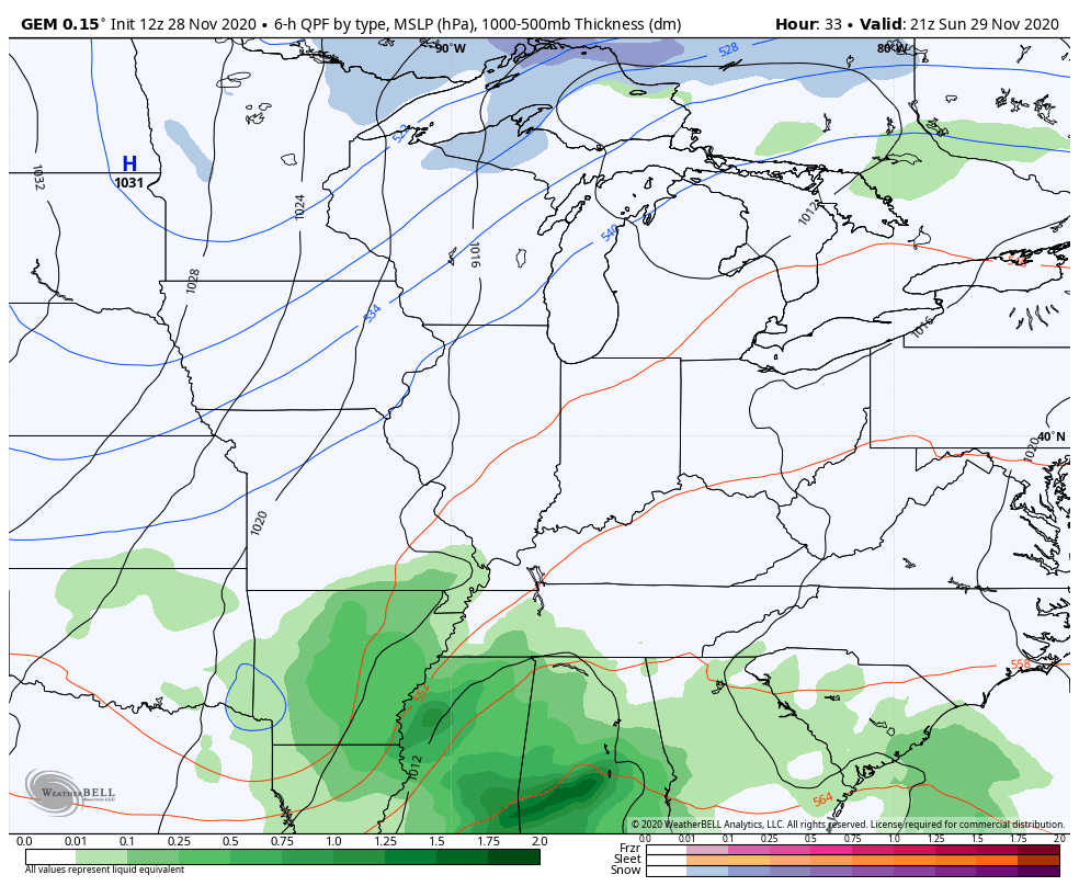
The rest of the models are stronger with the low and farther west…
EURO
CANADIAN
Short Range Canadian…
Even the NAM is correcting itself to fit the other models with the low…
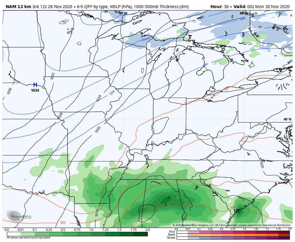
The HI RES NAM only goes through 7pm Monday, but it has a stronger low than above. Look at the future radar during this time…
Most of that snow is from the surface low then you can seeing the northwest flow kicking in at the end of the run as it connects the action to Lake Michigan. Here’s the snow forecast from that model run through 7pm Monday…
That seems overzealous to me, but if the surface low is stronger… Maybe.
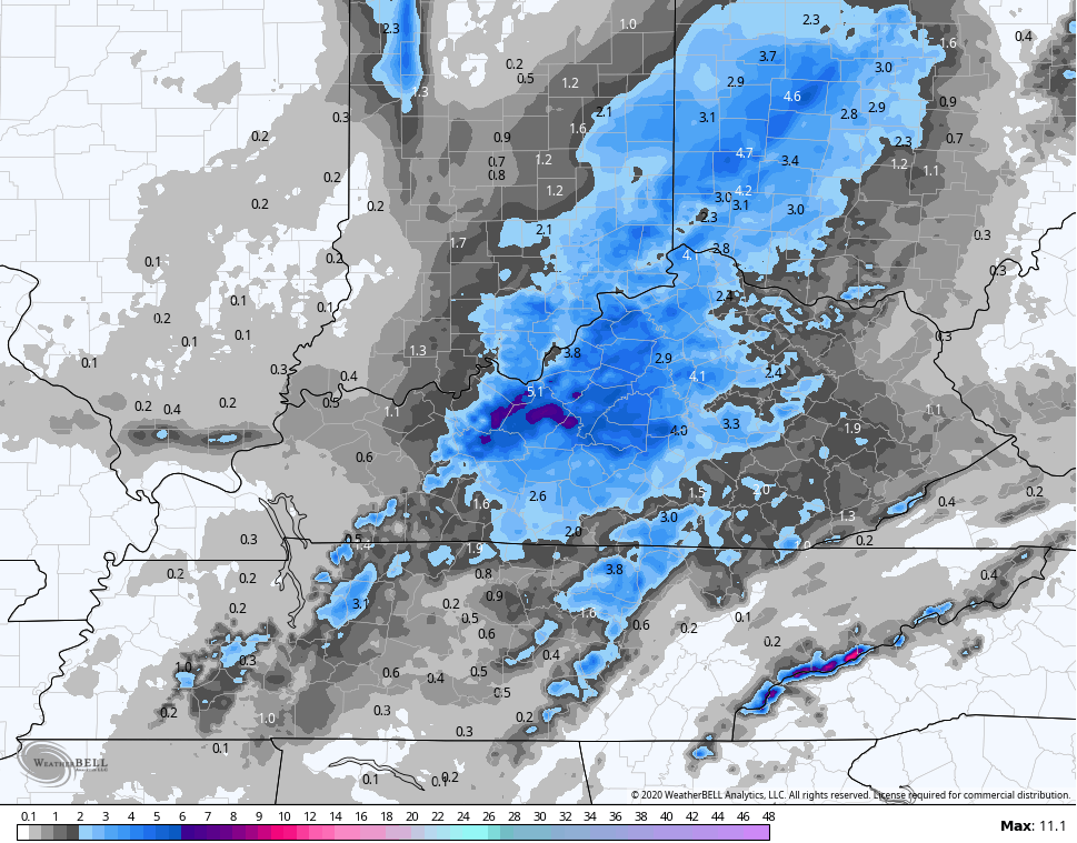
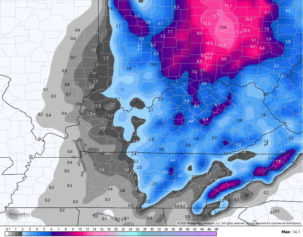
The NAM snow forecast through 7pm Tuesday…
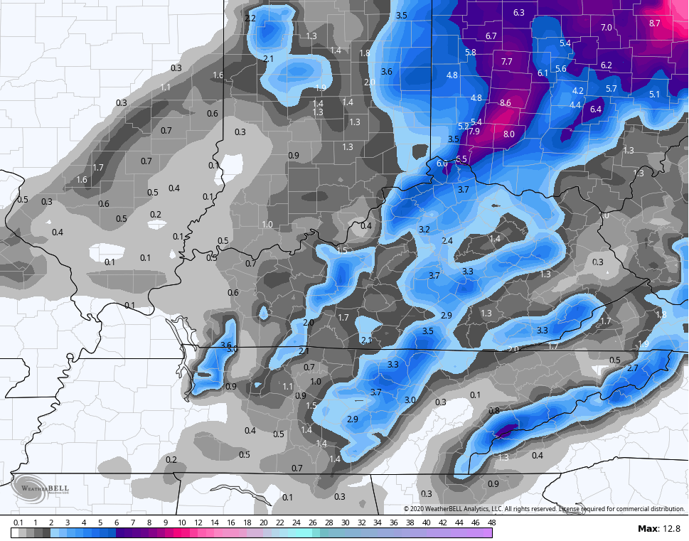
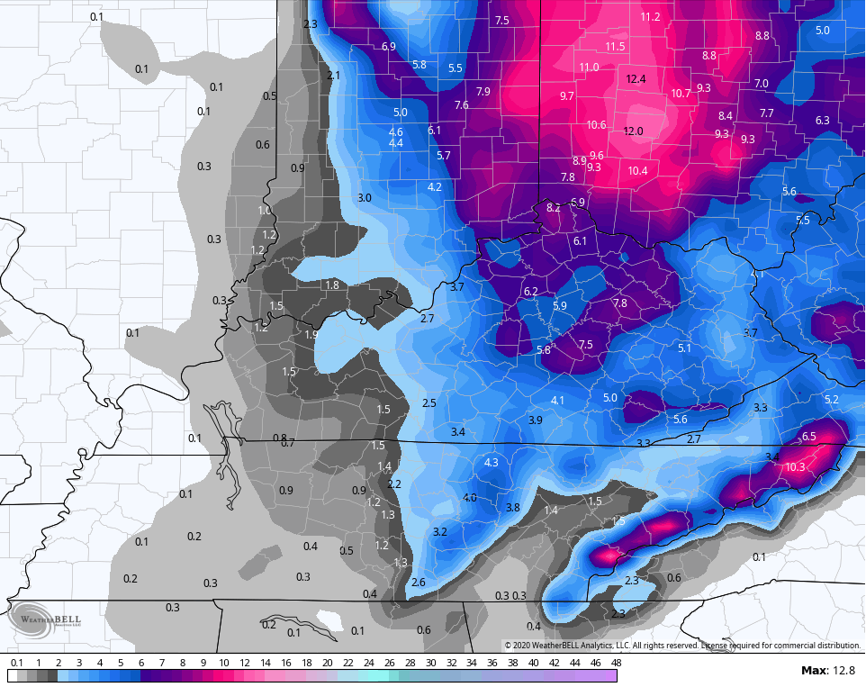
Short Range Canadian through the same time…
CANADIAN
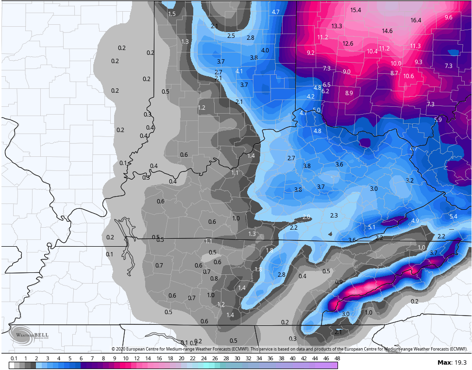
EURO
And the GFS…
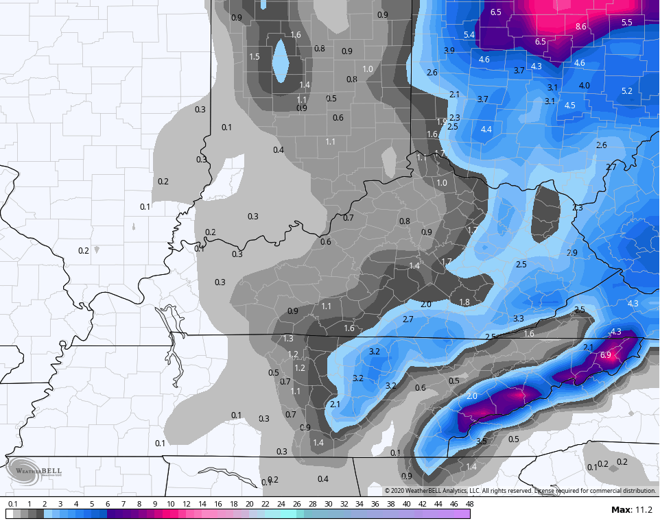
So even the model that is whiffing on the surface low is still putting snow down with a weaker northwest flow behind it. That’s the floor of the event, folks. Obviously, a few of the above models go above my ceiling and raise the roof.
Oh and another thing I have to always remind you guys of… The above models are NOT showing snow depth. Those are showing snowfall during their respective time frame. They don’t take melting or compacting into the equation.
The system coming in behind this is also on my radar for the end of the week into the weekend.
Updates through the day. Have a good one and take care.

Getting close to the point where we can move from models to forecasts… Hopefully, some of hte old timers / regulars start to resurface and share some thoughts, ideas and complaints about they haven’t had snow in _____ years do to some local anomaly or another. (Hey, I said that with love – I’m right there with ya! I love snow and can never have enough.)
Tbh, I sure did like the way the old comment section looked compared to this one… I only comment in the Winter,..just curious, why has there only been 5/6 comments on every post since we have been tracking this system over last several days???
I wonder the same thing….. I think that we as readers need to jump but not feel the need to monopolize. We need a lot of disparate thoughts, ideas and opinions rather than a few folks posting about half of all comments. ……
And I won’t even complain about my part of Richmond not getting the snow I always want 🙂
Guys I really think that the last two winters was dull that might have something to do with. Not knocking on Chris I really don’t know what’s gonna happen untill it’s hits. Mother nature has magic under the sleeve that we cannot predict. And I think this one is one of them.
Might be time for a server upgrade…Been taking 1-3 minutes for the site to load lately