Good Monday everyone. Sandy continues to churn toward a history making landfall along the New Jersey coastline later today or tonight. This storm will then join forces with a nasty dip in the jet stream to produce a severe nor’easter. As we have talked about many times… this has never happened before in recorded history.
Our superstorm will then slowly work toward the west and southwest and throw moisture back into central and eastern Kentucky. This will be in the form of rain and snow and the snow aspect is what’s getting everyone’s attention. We are just days away from Halloween and, not only are we talking about the first flakes of the season flying, but also the fist accumulating snows for many.
The latest snowfall maps from the models continue to hold course…
NAM

GFS

The GFS shows a much colder thermal profile for later today through Tuesday and thus shows higher totals and a better chance of accumulations into central Kentucky.
I am going to go the safe route and hold the numbers I put out Sunday afternoon…

I continue to show a fairly large spread because of the melting factor, but the numbers coming from the models say I’m underdone. I will put out a couple more snowfall maps later today and a final call will be the one that will be of record.
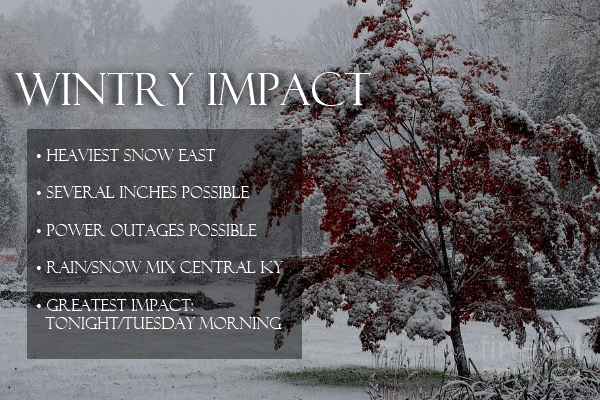
This isn’t a one trick pony of a storm as it’s going to pack one heck of a punch across the state. Some of the highlights…

I will have updates throughout the day and will have updates via my twitter feed: @kentuckyweather . A 27 First Alert Severe Weather Day has been called on WKYT and this will carry us through the duration of the storm. That means you will see expanded weather coverage during the news shows and you will get live updates each and every hour on WKYT. I may not sleep this week. 🙂
Have a great Monday and take care.

http://www.youtube.com/watch?v=4_tM_hm_uzE
Coincidence????? or is it Planned?????
6z nam holds the steady hand!!
also NHC track is starting to reflect the southwest movement of the models
yea the mountain border counties going get funky like a M,ONKEY if u in the HIGH TERRAIN, its mainly a light rain/furrie event.
as not many people live 2000 feet up. friend tracking things reports 4 inches on BLACK MOUNTAIN already.
It’s crazy that the models are showing so much snow for the Ohio valley yet all out news shows is maybe some flurries and a lot of rain. I’m kind of hoping for a westerly turn. I’d like to see some snow…a lot of snow! I love it.
NWS has a WWA out for several EKY counties…..looks like they’re catching on.
only 4 or 5 counties that border the border counties. tha have HIGHER ELAVATIONS.
nothing catch on too. at NO TIME will the temps go below freezing unless uir HIGH,HIGH UP.
so there NOTHING to see here as far as 98 percent of the coverage area goes.
If you get some true dynamic cooling there’s a legit shot of getting temps below freezing.
The NWS went from saying rain and rain/snow mix to one to three slushy inches so I’d say thats a change seeing as how they said the rain/mix solution just 12 hours ago. I’ve not seen one single met that says that many EKY counties won’t see accumulating snow. In fact most are giving some pretty good totals in comparison to last year. I’d love for it to be a bust because losing power isn’t my thing but its looking like we won’t be that lucky. So yes, in a way, they are most definately coming around.
NWS in morristown has their ky/tn bordering counties in a winter weather advisory as well….I hate living on the EDGE of such a HISTORIC STORM!! as far as getting in on some of the action that is…
It seems Mr Harris went with the GFS on his snowfall map
Sandy closed the stock market today and possibly tomorrow. Now that is some serious stuff. Shoot, won’t be able to do any trading today 🙁
Can anyone tell me why Louisville and E-Town are opening shelters?
Train derailment in SW Jefferson Co in Louisville its a hazmat situation it happen right near the Ohio Valley Speedway
Thank you.
It is cold out and feels like sleet.
The difference between nam and gfs in my neck of the woods is 6-8″ versus nothing. What is the difference they are seeing? Is the gfs showing Sandy coming further west, therefore pushing snow further south and west? Story of my life, flirting with the
Edge of every storm. Never seem to get in on the real action!
Thanks for the update Chris! You are the Man!!
Hope you find time to catch a nap or two over the next few days.
NYC may shut down for the next week. Storm surge will be more than it can handle! All electric and half of their transportation is underground. Hope the people on Long Island have prepared for the worst and get the best. As Chris said, this has has never happend before in recorded history. Blizzard Warnings for Snowshoe. WVA. anyone up for some early season skiing???
The crazy year of extreme weather continues!!!!
Since the expected turn West happened a little more North, world this not shift the outlook a little more East as far a the more intense areas?
Seems that way to me.
“would” not world.
No, The Track hasn’t changed as far as land fall
Any changes?
Everything still a go?
CSM is live blogging Sandy…
http://www.csmonitor.com/Science/2012/1029/Hurricane-Sandy-Liveblog-Atlantic-City-flooding-as-storm-surge-begins-video