
Good Friday and Happy New Year! As we start another year, let me begin by thanking each of you for making KWC an awesome weather community. Here’s hoping 2021 brings you nothing but joy, happiness, love, peace and health. Life is too short for anything less.
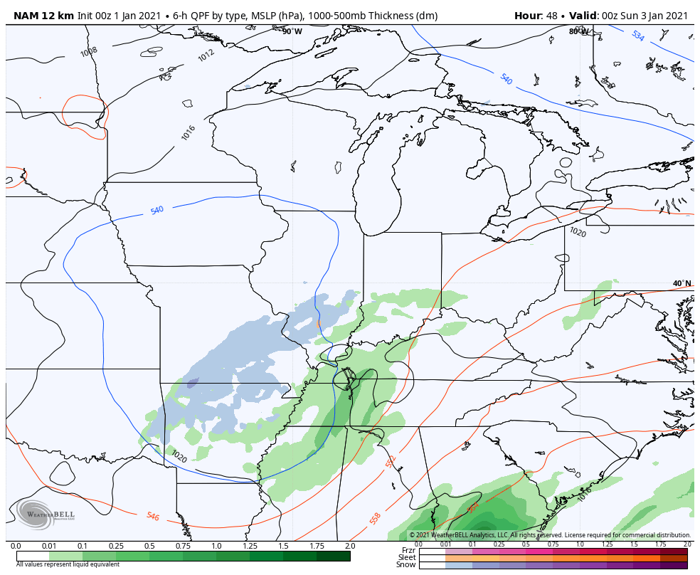
So, what will the new year bring for us when it comes to the weather? Things are starting out on a rather wild note today with a big low pressure rolling through the Mississippi Valley. This brings a lot of rain into the region early today and this may start as a touch of freezing rain in the north. From there, rounds of heavy rain and a few thunderstorms work through. There’s even the chance for a few strong storms across parts of the state.
Here’s the area in the low-end threat for severe weather from the Storm Prediction Center…

We will keep an eye on those storms that go up from late morning into the afternoon. Skies may even try to clean up for a while with some sun at some point. If that happens, we would then need to watch for a line of storms popping along the front working in by early evening. Temps could also make a run at 70 in a few spots. Wait… What? Yep… 70 if we can get sun. 😲
Reality sweeps back in behind this system on Saturday as the numbers come back down into the upper 30s and middle 40s. A leftover shower will be possible early.
The next system rolls in quickly by Saturday evening with rain overspreading the region, but a period of snow will be noted on the backside of this. As this system moves through on Sunday, temps come down with some flakes trying to show up…
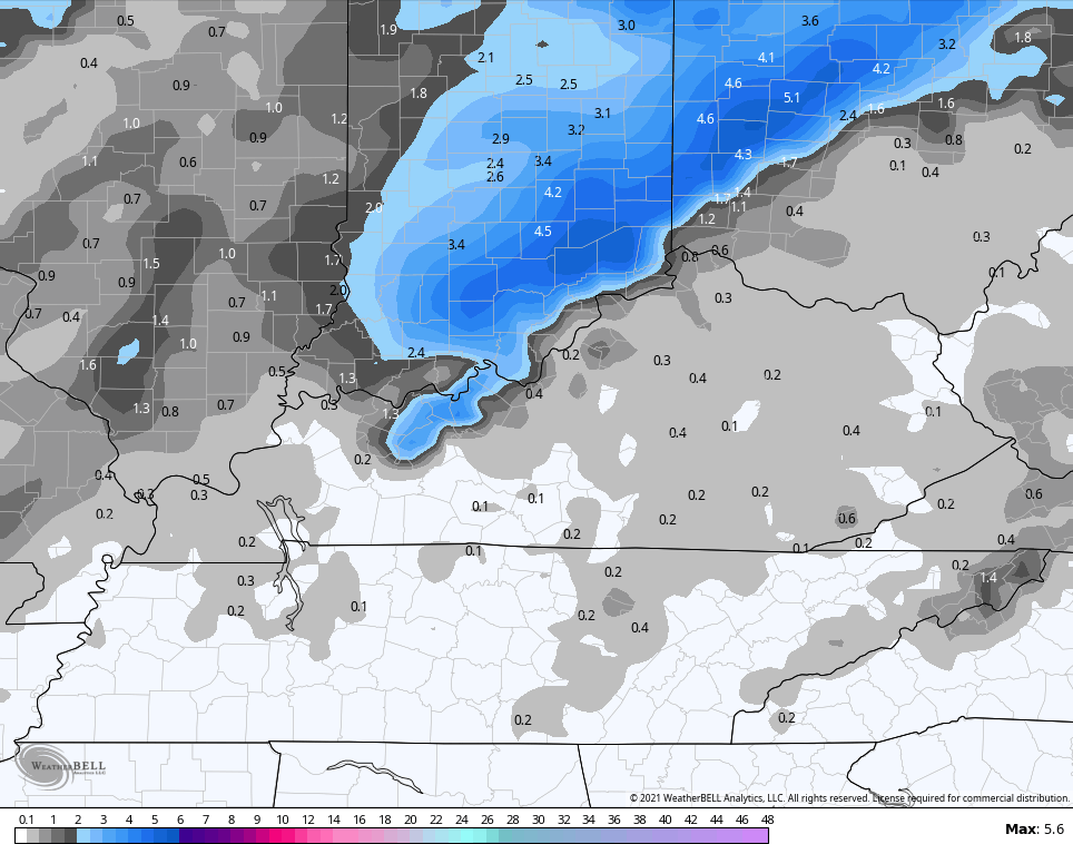
The NAM is showing some of those flakes through Monday morning. Check out the snowfall just to the northwest of Ohio River…
The pattern from here tries to start cranking out a few winter weather threats earlier than I thought. The Canadian was first to sniff this out as a few days ago and now we are seeing the other models going in that direction. The Canadian has a glancing blow from a clipper on Tuesday, with a much bigger system by the end of the week…

The GFS is even picking up on both of those now…

The EURO is slower with the end of the week system, but has a nice looking storm system and has another system right behind it…

I’ve been targeting week two of January for the real return of this winter pattern as our blocking really begins to flex. I see no signs to alter my thinking. Check out this block and trough developing underneath it right on top of us…
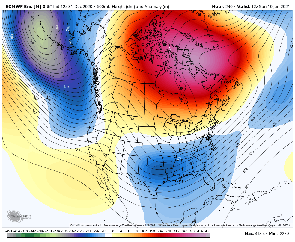
That, my friends, is the look of a stormy pattern that can target our region with winter storms.💪❄
Updates will come your way later today. Until then, I leave you with your rain and storm tracking tools to start the new year…

Current Watches

Potential Watch Areas

Have a great start to the year and take care.

Happy New Weather Year Chris
I hope this year there are some BIG POSITIVE CHANGES for EVERYONE !!!
In one week we went from a beautiful White Christmas in Eastern Kentucky to mud and slop to start the New Year. Not a good sign Folks.
For my area, weather forecasters are calling for a high temperature near 70 degrees later this afternoon as the warm front lifts to our North and cutting off the rain.
Good news is that mild to cool temperatures are forecast to hold through mid month so our heating bills will be low. Bad news is if it does get colder will our precipitation be Ice or Snow or just plain cold and dry ? Hopefully some Big Time Snowstorms that trend one after the other and not the ones that melt in a few days.
Happy New Year!