Good evening, everyone. With our light snow maker rolling toward the region from the west, A Winter Weather Advisory is now out for much of the region Wednesday into Wednesday night. My thoughts on this system haven’t really changed, but the potential exists for this system to ramp up just a little more. I’m also closely watching the weekend winter weather setup.
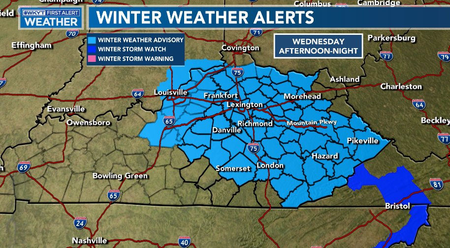
Here’s a look at the current Winter Weather Advisory…
I’m going to go ahead and keep the current Call For Snowfall…

I will update that on WKYT tonight at 11 and then on KWC later tonight.
The latest model forecasts continue to point toward a decent snowfall out of this. The GFS continues to show a more widespread event…

The EURO is on board with that idea…

The Short Range Canadian is trying to do the same…

The NAM is also beefier than earlier…

Hi Res NAM

The HRRR has a much more solid band of snowfall from west to east…

The weekend setup continues to look VERY interesting, especially on the EURO. The model continues to have a thumping snow late Saturday into early Sunday before going over to light rain then back to snow…

The GFS Ensembles are also hitting this very well. Here is the average snowfall through Monday from the 51 member EURO Ensembles…

We will tackle this mess later tonight. Have a good one and take care.

I’m guessing the GFS is suppressing the storm too far south for tomorrow and I will actually get 1-2″ of snow here in south-central Indiana, but my attention is focused on that weekend system.
WKY looks to miss out again not even in the WWA
Did someone built a dome over us here in western, ky. It sure is weird. Lol