Good afternoon, folks. We have a sunny, but cold day in progress across the Commonwealth. As we roll into the weekend, another storm system rolls our way and looks to bring a little of everything with it. It’s a setup that goes from snow/mix to rain then back to snow.
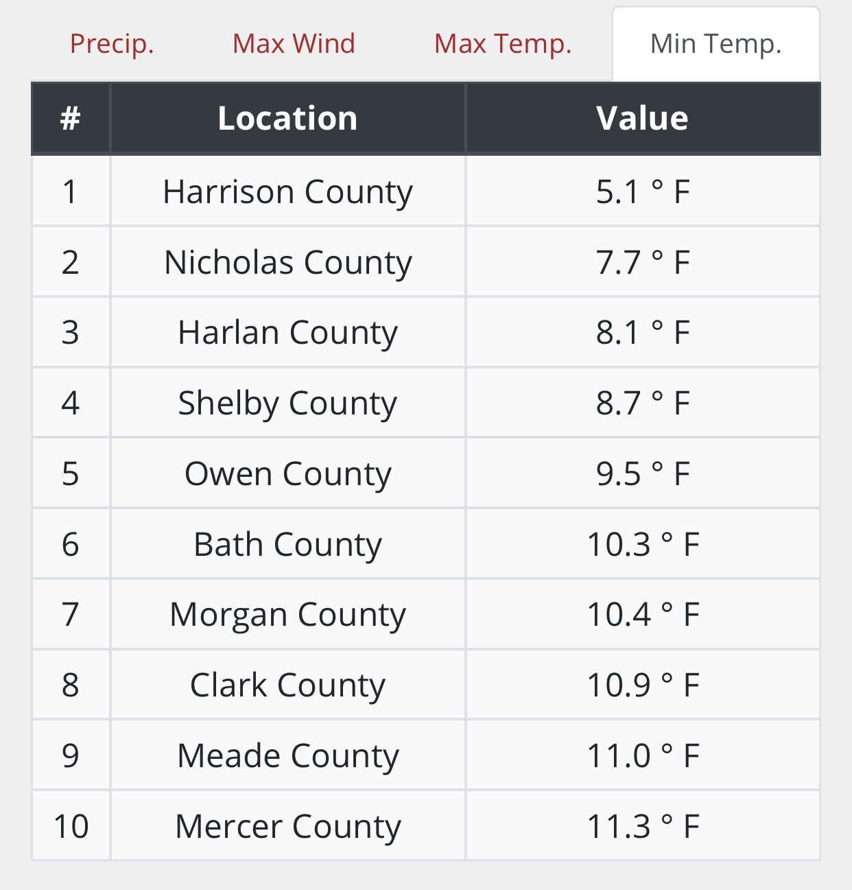
The snowpack and clear skies knocked our temps way down this morning with several areas hitting the single digits. Here are the coldest thermometers from the Kentucky Mesonet…
Ok, let’s talk about the frontend winter weather potential late Saturday and Saturday night. Here’s a breakdown of the areas most at risk…

Here’s how the models see the winter part of this through Sunday afternoon…
EURO

Canadian

Short Range Canadian

GFS

Everyone in the state sees rain for Sunday as low pressure works in here and weakens. This low will then move east and allow colder air to switch the rain over to light snow, snow showers and snow squalls. Light accumulations are likely from Sunday night through early Tuesday. Here’s a breakdown of that setup…

Here’s the total snowfall map from the EURO through Tuesday…

As we look toward February, we find the temps increasing for a few days during the second half of next week, but the trend for a colder than normal month continues to show up for much of the country. Look at the temp departures from the GFS Ensembles through early March…

Control run for the same time…

Notice that warmer air across the southeast? That likely sets up a very active storm track through here. The end result would be lots of rain and snow in our part of the world.
I will have another update this evening, so check back. Have a good one and take care.

Winter Storm Watches are in effect for parts of five states from Saturday afternoon through Sunday morning, including all of Northern IL and Northern and Central Indiana.
The Euro is the most aggressive of the models, predicting between 13-15 inches of snow for the Chicago Metro area by the time it’s over, while the Canadian and GFS are predicting 8-9 inches. The GFS really increased the snowfall amounts from their model last night, and it now appears it’s coming around in agreement with the other computer models.
The NWS Chicago is predicting 6-10 inches of snow for the area, with locally higher amounts. They are really concerned about travel becoming dangerous quickly because of the heavy snow rate (1 to 2 inches an hour) and strong easterly winds over 30 MPH cutting visibility to as low as a quarter mile for several hours.
I’ll definitely be taking an Uber to work tomorrow afternoon and hope I can make it home at night!
Stay safe Man!
Back to the same routine. Rain followed by a dusting of snow.
If the long distance models hold up.
We might have a chance for one decent snowfall. (above 6”)
I would be satisfied if we continue the modified Arctic Air along with the one to two inch Snowfalls every other day with Sunshine in between.
it is what it is. Other people’s snow. Just think of them shoveling all that and you might feel better 😉
Actually I like shoveling snow it makes for a great aerobic workout . Although I would not want to do it everyday.
You are lucky you have your health and youth to shovel the Snow. My days of shoveling Snow are over according to my Doctor.
I remember one year I had to shovel Snow away from the doors to my many Greenhouses to get inside, and this was on March 21st.
It is good for me living here in Kentucky as really big snowstorms are rare and the ones we get are melted and gone in a few days.