Good Tuesday to one and all. Typical summertime temps are with us out there today as we start to see more and more storms bubble up. These storms will continue to increase this week as the first of two cold fronts sweeps in here. The second one arrives over the weekend.
Before we get into the forecast, let’s review the Monday high temps from the Kentucky Mesonet…
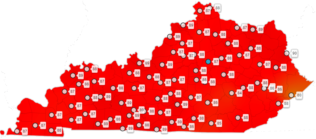
As you can see, mid and upper 80s were the rule and those numbers are 100% in the normal range for the 5th day of July. Unfortunately, a lot of the weather community on Twitter was complaining about how hot the day was. Mid and upper 80s in July is now considered “hot” by an increasing number of weather folks. We now have a full group of professional weather people who have no idea what the climatology of this region is and the worst part is, they don’t seem to care to find out.
PS… GET OFF MY LAWN! 👴
Today will feature similar temps with most in the 85-90 degree range with humidity making it feel sticky out there. A couple of showers and storms will then go up during the afternoon and evening. Here are your radars to follow along…

Tropical Storm Elsa is emerging from the coast of Cuba and working toward the eastern Gulf Of Mexico…

This may very well become a weak hurricane before it heads toward the Big Bend of Florida later tonight and early Wednesday. From there, this may go inland up the coast and could maintain tropical storm intensity. Here’s the latest info and track forecast from the National Hurricane Center…

That will stay well east of us and won’t have any direct impact. My thought all along was for a cold front to work through here and keep this thing to our east and that still looks good…

Showers and storms will increase here from Wednesday through early Friday. With high humidity in place, torrential rains may cause some localized issues.
The next system arrives this weekend and will have a quick surge in temps ahead of it. This may help fuel the fire for a few stronger storms and heavy rain, but the models are having some handling issues with all this…
EURO through the middle of next week…

Looking deeper down the road, we will find a run of toasty temps making a run at us for the middle of the month, but this will likely get cut off at the pass. Watch how the EURO Ensembles take the ridge back into the west and develop a trough back into our region…

Have a great day and take care.

Thanks Chris, to me the Summer so far seems typical for the Ohio River Valley. Both in temperature and precipitation. It’s after the forth, so I’m ready for Autumn and Winter talk.
Watching Tropical Storm Elsa as I have relations that live along the west coast of Florida.
They have not been around long enough to know what happens in KY weather. I have seen the temperature stay above 80 day and night for long periods of time that’s hot.
I’ve lived in KY for 21 years now. We’ve had far hotter summers than this one, by far. My personal experience has been that there’s a six week or so period where it stays hot during July and about half of August before temperatures start to moderate a little. We’ve had summers that dragged into late October. We’ve had summers where we had >40 days of highs >90 deg. I’ve recorded 2 so far this year.
I’ve also spent two summers down in Acadiana. Trust me, there’s no hot like a South Central Louisiana hot.
The rest of the weather community needs to chill. As you’ve stated, this is totally normal.
I agree with the comments some people just haven’t no clue what hot is when it comes to ky weather. It’s either there to young or they tried to make there own term of what the weather is.
The years when we had the hottest temperatures during the Summer months (triple digits) almost always followed cold Snowy Winters.
It hit 91 yesterday at Chicago’s O’Hare Airport, and 88 at the NWS Forecast Office in the SW Suburbs. Heat index readings reached the mid-90’s.
Normal highs here for this time of year are 84-85.
I have lived in KY. 57 years and I can remember it being so hot and the humidity so high you would feel like you are stepping in an oven going outside. I don’t like it that hot!
But July and August is supposed to be 90 degree days and 78 to 85 at night. My thoughts. Have a great week everyone.
Severe thunderstorm headed this way!