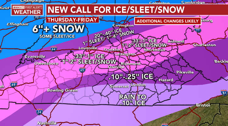
Good Thursday, everyone. A major ice storm and winter storm continues to overspread the state today and is going to bring significant issues with it. For some, this is a devastating ice storm through early Friday.
Here’s a look at my latest Call For Ice/Sleet and Snow…
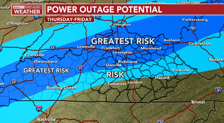
Areas dealing with significant amounts of freezing rain will likely experience tree damage and power outages. Here’s a look at the area I’m highlighting for the best chance for power outages through Friday…
Again, this will be a devastating ice storm for a lot of folks and will likely shut down much of the state for, at least, a time.
With the increasing potential for significant power outages that could last for days, it’s VERY concerning to see the amount of cold coming in behind this. Friday night temps may very well drop below zero for areas with ice and snow on the ground…

I will have updates later today and will have the later on WKYT-TV throughout the day. Until then, I have you all set to track today’s ice storm/winter storm…

LEXINGTON


LOUISVILLE


COVINGTON AREA


FRANKFORT


GEORGETOWN

BOWLING GREEN


PADUCAH

FORT CAMPBELL

MOUNTAIN PARKWAY NEAR SLADE

MOREHEAD


MAYSVILLE

Stay safe out there and take care.

I am team sleet today.
Everything is glaze this morning at my neck of woods here in western ky and still getting pounded not looking good folks. Stay safe
God Bless You and be Safe.
Thanks Chris for all your hard work during these anxious times. Right now in Maple we are in a dry slot with a temperature of 39 degrees and falling. One interesting feature on the severe weather map shows a moderate risk to our south. I was just wondering if this will save us by providing a warm tongue of air over South Central and Southeast Kentucky ?
Unfortunately, the Power and Communication Companies which we really rely on for providing valuable and life saving services have not advance in this Century. If they would have we wouldn’t be talking about life threatening interruptions during severe weather events.
It’s 35° right now at my PWS near Bowling Green. I have recorded 1.75″ of precip. since the storm began. mostly rain but a bit of sleet has mixed in over the past hour. Radar indicates the rain/freezing rain line is just west of Russellvillethat. We’re on the “cold” side of the front, so changeover could occur within a few of hours.
WRECC and BGMU are not displaying any storm-related power outages at this times.
Hang in there, best of luck to everyone!
I hope this thing is an under-achiever. Good luck everyone!
Joe, its 34 degrees here in Maple, and the Rain has begun after a pause earlier.
So far we have had .87 inches of just plain Rain.
I expect the ICE will come later this afternoon ?
What happened to the “good Ole Days” when we had a set up like this and every area received Snow ?
Take Care
Glad to hear that Maple area is so far doing well talked with my uncle down there earlier. I agree with your observation about weather of past being mainly snow events, over the last decade seems like we get more “warm noses” aka ice. I got a gut feeling that we may more in a warm nose now as the transition from rain to ice has taken alot longer then forcast here in Fayette county. So every hour we can keep that temp above 32 and just get rain cuts down on that ice accumulation. Take care.
I sure miss those days as well! I just checked the current water vapor imagery, and the flow from the Gulf is massive. Activity in the tornado watch area may siphon some, but there seems to be more than enough moisture for the storm and watch areas to work with.
Please take care, and NO SHOVELING! There’ll be a lot of weather to see in 2022 and beyond, so we in the over 70 crowd need to make sure we’re around to see it!!
A Tornado Watch has been issued for some of the Southern States. I hoping that will take some of the “starch” out of this awful Storm for all of Kentucky.
Take Care Ricvice !
Here is the summary of the major snowstorm that affected the Chicago Metro Area from late Tuesday through Wednesday, which saw Chicago’s Midway Airport receive 11 inches and the NWS Forecast Office in the SW Suburbs receive 10 inches. https://weather.gov/lot/2022feb2
It’s a very picturesque Winter Wonderland for sure around here, and we finally surpassed Kentucky for snowfall so far this season!
Everyone in Kentucky stay safe during the ice storm!
Here is the summary of the major snowstorm that affected the Chicago Metro Area late Tuesday into Wednesday, with Chicago’s Midway Airport receiving 11.0 inches of snow and the NWS Forecast Office in the SW Suburbs receiving 10.0 inches: https:..weather.gov/lot/2022feb2
It’s a very picturesque scene outside here with all the snow, even though it’s freezing cold with a temperature of 21 degrees and a wind chill in the low single digits
Sorry for the bad link, here is the correct link: https://weather.gov/lot/2022feb2
A good Snow for you. We still have plain Rain here in Maple and I expect Freezing Rain tonight hopefully it will end early Friday ? No Snow expected here.
Take Care Mike
32 here in the East end of Louisville with steady freezing rain falling. Deck is starting to freeze and trees are glazing over now. Winds are not constant, but picking up , concerned especially through the evening and over night.
Ice with power outages in Southern Indiana spreading slowly eastward. Large tornado near Salyersville Alabama. Crazy weather pattern.
Figured the cooler air would be more East by now..Looks like the Nam may have nailed this so far with the amounts and areas..Guess we’ll see..
My PWS near Bowling Green just reported a low temperature for the day of 34.5° about 15 minutes ago, and it’s been holding steady since then. Radar is showing some sleet aloft, but it’s not hitting the ground. A strong flow of moisture continues, although a dry slot seems to be forming in the Columbia, TN area. Hopefully it will shorten the time during which freezing rain can form, once our temperature actually dips below freezing.
The Energy to our south hopefully will limit this Storm.
Hate to here about the Tornadoes in Alabama.
So far my power has held on in my household here in western ky. There have been some widespread outages surrounding my area so far nothing like it was 2009. The freezing rain still coming down but not heavy as it was earlier.
Glad you are Okay and you still have your power. You must have a great Power Company. Let me guess Great Rivers ?
I heard that Evansville, Indiana got clobbered with Ice from Freezing Rain with power outages ?
The Rain has ended here as the temperature has now dropped to freezing.
I think that the severe weather in the South has cut off the Gulf moisture for now ?
Here’s a link that shows power outages statewide:
https://kyelectric.coop/kentucky-coop-outage-map/