Good Thursday to one and all. After another round of severe weather, things are calming down for a few days. This calm weather takes us into the close of the week but a couple systems are set to impact the weather through Easter Weekend. As this happens, it turns much colder once again.
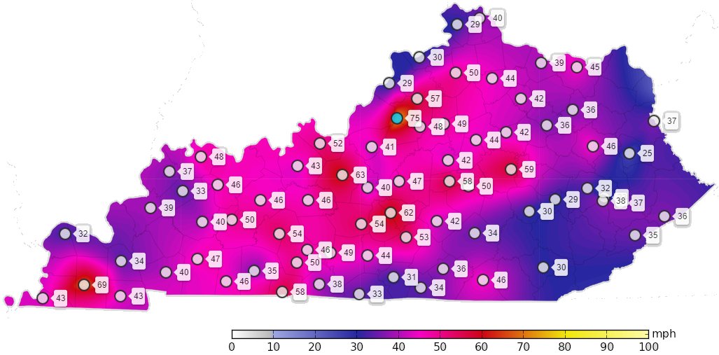
The severe weather of Wednesday was everything it was supposed to be and then some. Hurricane force wind gusts showed up once again across the state. Check out the peak wind gust map through 11pm last night from the Kentucky Mesonet…
Let’s begin with today and hit the fast-forward button. Showers and storms hang around eastern Kentucky very early today before pushing east my mid-morning. Here are your radars to follow along…

Sunny skies control during the afternoon as winds gust up and temps reach the upper 50s to middle 60s.
Friday’s weather looks even better with some clouds increasing and highs around 70 degrees for most of the state. Those clouds are ahead of a cold front sinking in from the northwest Friday night and early Saturday. This can touch off a shower or thunderstorm Friday evening with the greatest concentration Friday night and Saturday morning…

Chilly air comes in behind that for Saturday into Easter Sunday with well below normal temps. The next system then zips in late Sunday into Monday morning and the EURO continues to show a flake chance with this…

Let’s go with a chilly shower instead of a flake, but it’s still nasty.
Temps do stay well below normal through the middle of next week, but there are signs of a warmer surge late next week. The EURO tries to turn toasty…

Yes, please!
Have a terrific Thursday and take care.

The storm, preceeded by an impressive shelf cloud, hit the Bowling Green area about 7:00 pm CDT. Around that time my PWS recorded a peak wind gust of 51 mph, and a temperature drop of 14° in about 10 minutes. I also lost power for about 2 hours, and wasn’t alone as WarrenRECC reported that approximately 6,100 customers had also lost power.Some property damage was reported, but all in all, we’re thankful that there was no loss of loss of life!
We had another “close call” yesterday late evening. Tornado Warnings went up for many counties in the surrounding areas.
Only 0.68 inches of Rain and peak wind gust was only 28 mph. No damage or power lost reported.
Looking forward to calmer days ahead.
The Wind Advisory has been upgraded to a High Wind Warning for the entire Chicago Metro Area through 7 PM this evening. West to SW winds gusting up to 60 MPH are possible.
It’s a bright, sunny, but very windy and chilly day here with temps only in the low 40s.