Good Friday to one and all. Rounds of strong and severe storms have targeted the region over the past few days and today looks like another stormy one. This action is ahead of a front settling through here for a better feeling weekend with larger changes coming next week.
Once again, we are watching the western and northwestern skies for clusters of strong to severe storms working in. Just like we’ve seen in recent days, damaging wind is the primary player.
Here’s the latest Severe Weather Outlook from the Storm Prediction Center…

Additional showers and some thunderstorms will be around into Saturday as the severe threat gets pushed farther south…

Flash flooding issues may show up at any point through early Saturday as these storms can put down a lot of rain in a short amount of time.
Sunday’s weather looks really good with pleasant temps and comfy humidity and that lingers into Monday.
Another cold front then shows up late Tuesday into Wednesday and may bring some more showers and storms with it…

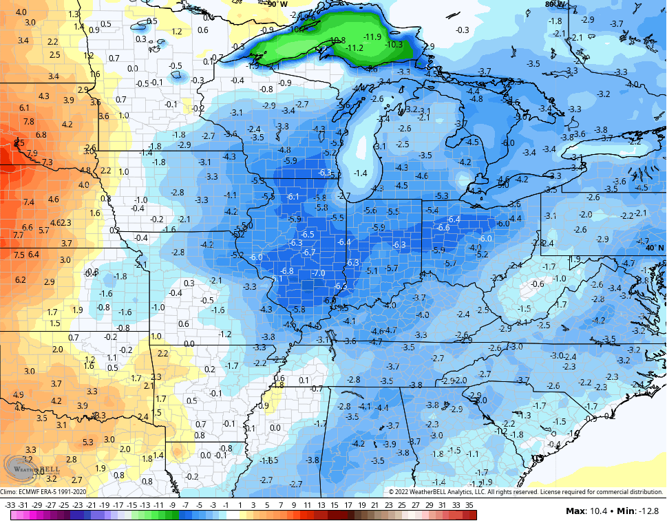
Temps come way down behind that and might actually be pleasant for much of the middle and end of next week. Look at the 5 day temp departures behind the front…
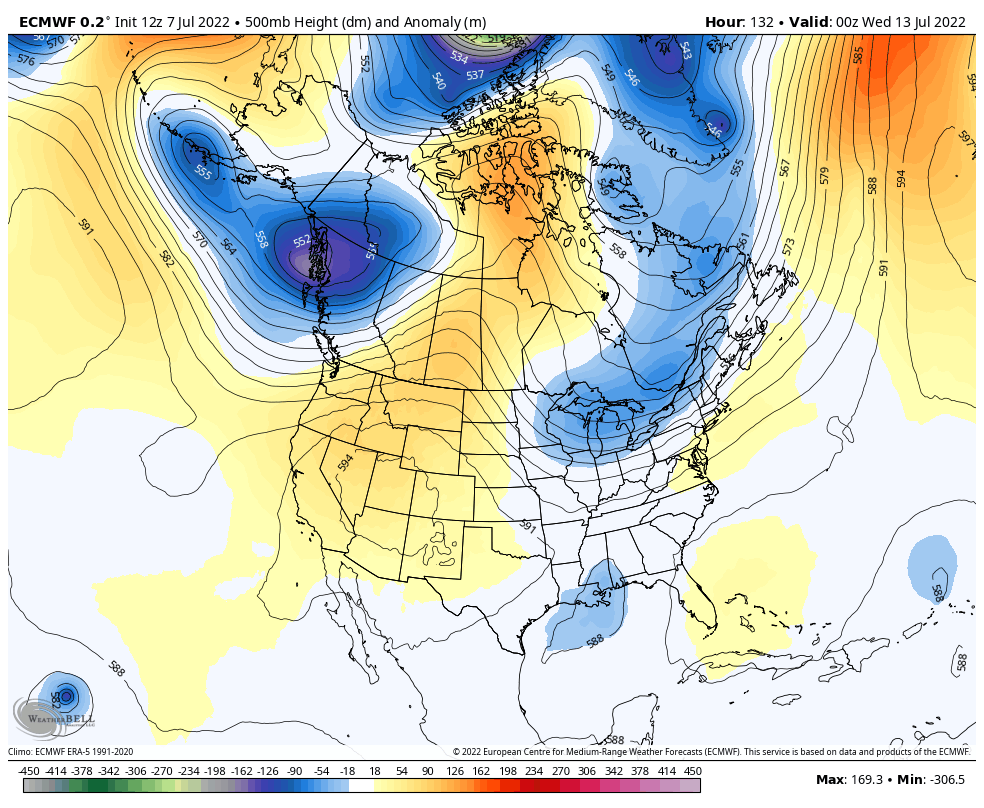
That cooler look is supported by the EURO which shows a nice trough digging in here…
Don’t be surprised if the heat doesn’t make another big run at us the following week.
I will have the latest on WKYT-TV starting at 4pm so tune in as I track the severe threat and the heat wave. As always, I have you all set to track any severe weather out there today…

Current watches

Possible Watch Areas

Make it a great Friday and take care.

I like this up and down stuff. 🙂
It was humid, but we sat on the darkened front porch last night and listened to the drizzle. It was almost over before the areas under the big trees even got wet, but the sound of drops hitting the leaves was so pleasant.
Yesterday evening we received 0.48 inches of pop up rain showers. A good start to ending this horrible drought. Cooler temperatures predicted (all though short lived) I’m sure will be welcome by many.
Several rounds of strong storms made a run at the Bowling Green area yesterday, but only the remnant of an outflow-spawned storm managed to push through town and made it into my area, which lies just south of the city. Once again, these storm were extremely localized, in fact this is the first time that I can remember where the rainfall reported at the WKU Farm Mesonet site, which is located only 2 miles NW of my location, received a rain amount that was greater than the amount recorded by my PWS.
0.75″ vs. 0.25″!
Over the past 32 days, we’ve received 1.31″ of rain, of which 1.14″ fell last Saturday, so localized drought conditions remain firmly entrenched, especially in South-Central Warren County. Hopefully we’ll get a more substantial rainfall out of today’s storms.
I watched a storm on radar all day that was headed towards my home only to see it weakened when it neared the river.
All I received from the storm was sprinkles.