Good Thursday, everyone. Temps are down a little bit today, but the numbers bounce back with vengeance for the weekend. This sets the stage for some big time heat index numbers before storms take control of the pattern early next week. That could be a wet setup.
Let’s focus on the breakdown of what’s going on and what’s about to go down:
TODAY
- Temps come down a bit as a cold front works through the region.
- Highs are in the upper 80s to near 90 much of central and eastern Kentucky.
- 90-95 hangs on in the west.
- A few showers and storms may linger into the morning hours. Here are your radars to follow the action out of town…

FRIDAY
- Temps reach the low 90s east with middle and upper 90s far west.
- Humidity levels make it feel 95-100 east and 100-105 west.
- There’s a small chance for a popcorn shower or storm.
SATURDAY
- This looks like the hottest day of the bunch.
- Highs reach the mid and upper 90s for much of central and eastern Kentucky.
- The west makes a run at 100 degrees.
- Heat index values are firmly into the danger category ranging from 100-115 across the state.
- There’s a small chance for a shower or storm to pop up.
SUNDAY
- Temps are similar to the Saturday numbers but may come down just a touch.
- The heat index is still in the danger category.
- Some showers and storms fire up late in the day.
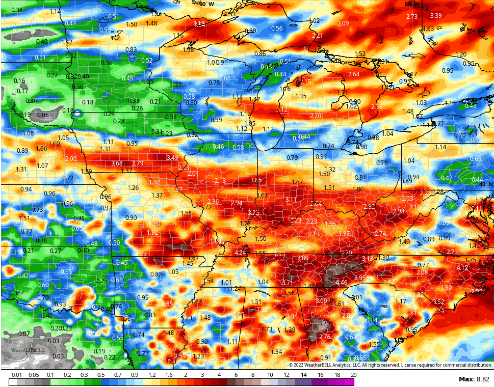
The threat for showers and storms will really increase by Monday and Tuesday as a boundary works in from the northwest. This slows down on top of the region through the week and this likely keeps rounds of storms rolling through here. You can see that on the GFS animation that starts Sunday night and goes through the final day of the month…

The GFS rainfall numbers look like this during that time…
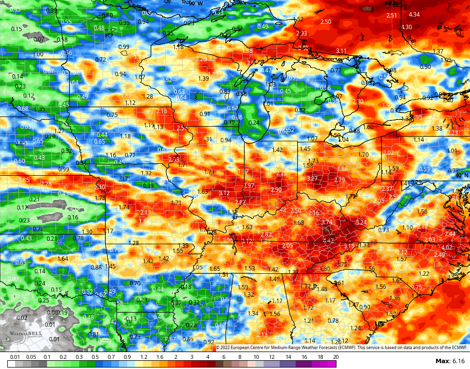
The EURO doesn’t go out as far in time, but has a similar look…
Wet weather will bring cooler temps to the region, so that’s all good!
Enjoy the day and take care.

Very surprised that Richmond got no rain out of this. I did enjoy the light show south and east, though. 😉
Storms were breaking out all around my area just south of Bowling Green, but we didn’t see a drop until the the last line went through (instead of around) around 2:00am CDT, and squeezed out a quick 0.90″ in about 15 minutes. Earlier in the day it was brutally hot. The thermometer at my PWS briefly hit 100°F, but the killer was the dewpoint, which hit a stifling 83.5°F. The combination led to the highest Heat Index I’ve ever recorded, 128.6°F. My wife who has mild asthma, and had gone out to run some errands, returned immediately because she couldn’t breathe.
This kind of weather can be deadly for individuals with respiratory illnesses, so be careful out there everyone!
Earlier this morning we received only 0.37 inches of rain / showers accompanied by lots of loud thunder and lightning. We welcome every drop of rain we receive. That is an amazing dewpoint reading Joe and I hope you and your Family are safe and well along with everyone else. This awful weather pattern can’t last too much longer I hope.
Schroeder, my wife lived in Louisiana for a time, and she said that these atmospheric condition are considerably worse. I’ve found through some research that humidity and dewpoint values are more sensitive to local conditions than temperature. Where I live, we have a mixture of mature trees and open areas, along with a catch basin, which taken together is why I usually record higher humidity levels than the Warren County (Farm) mesonet site, which is located in an open field. That said though, the current conditions go WAY beyond anything I’ve experienced during the 26 years I’ve lived here, and that include 2012!
When we hit 90°F today, we will pass 47 days of 90°F or more, which is our area’s average number of days for the YEAR! That’s sobering when you consider that slightly less than half of Summer remains.
It’s more of the same, at least over the short term, with the coming 5-day forecast predicting 94°F, 97°F, 100°F, 99°F and 91°F.
Schroeder, my wife lived in Louisiana for a time, and she said that these atmospheric condition are considerably worse. I’ve found through some research that humidity and dewpoint values are more sensitive to local conditions than temperature. Where I live, we have a mixture of mature trees and open areas, along with a catch basin, which taken together is why I usually record higher humidity levels than the Warren County (Farm) mesonet site, which is located in an open field.
at said though, the current conditions go WAY beyond anything I’ve experienced during the 26 years I’ve lived here, and that include 2012!
When we hit 90°F today, we will pass 47 days of 90°F or more, which is o average number of days for the YEAR! That’s sobering when you consider that slightly less than half of Summer remains.
It’s more of the same, at least over the short term, with the coming 5-day forecast predicting 94°F, 97°F, 100°F, 99°F and 91°F.)l
That said though, the current conditions go WAY beyond anything I’ve experienced during the 26 years I’ve lived here, and that include 2012!
When we hit 90°F today, we will pass 47 days of 90°F or more, which is o average number of days for the YEAR! That’s sobering when you consider that slightly less than half of Summer remains.
It’s more of the same, at least over the short term, with the coming 5-day forecast predicting 94°F, 97°F, 100°F, 99°F and 91°F.)l
Joe, definitely your property would have higher dewpoints and humidity due to it’s natural terrain. I learned this when I had my Nursery, which had a lake with surrounding trees. A micro- climate.
The NAM 3km model is awful.
The model forecasted a broken line of storms to develop in Southern Indiana and move south.
That never came to fruition and here at my home in Louisville the skies never became overcast. I watched the sun go down after 9pm.
After reviewing commentary on other social media sites it appears the 3km actually has had a good year. The model had an off day yesterday.
Schroeder, my wife lived in Louisiana for a time, and she said that these atmospheric condition are considerably worse. I’ve found through some research that humidity and dewpoint values are more sensitive to local conditions than temperature. Where I live, we have a mixture of mature trees and open areas, along with a catch basin, which taken together is why I usually record higher humidity levels than the Warren County (Farm) mesonet site, which is located in an open field. That said though, the current conditions go WAY beyond anything I’ve experienced during the 26 years I’ve lived here, and that include 2012!
When we hit 90°F today, we will pass 47 days of 90°F or more, which is our area’s average number of days for the YEAR! That’s sobering when you consider that slightly less than half of Summer remains.
It’s more of the same, at least over the short term, with the coming 5-day forecast predicting 94°F, 97°F, 100°F, 99°F and 91°F.
Here’s an explanation why we have not had Tropical Storm development ; Hint, Saharan Desert dust in the area of the atmosphere where there should be storm development ;
https://www.wlrn.org/news/2022-07-08/atlantic-waters-remain-quiet-in-spite-of-hurricane-season-ramping-up
There certainly is an abundance of hot, dry air off the coast of Africa, stretching well out into the Atlantic, and putting the Main Development Region into timeout. This is also the time of the year when the Gulf of Mexico and the Caribbean Sea usually take center stage, but they are abnormally quiet. Sea Surface temperatures in the Gulf are in the mid to upper 80’s, with some low 90’s near the coastline. The catalyst to kick things off is not present, and this also holds for the eastern Pacific. We sure could use tropical kick-in-the-pants!